
mgerb
-
Posts
239 -
Joined
-
Last visited
Content Type
Profiles
Blogs
Forums
American Weather
Media Demo
Store
Gallery
Posts posted by mgerb
-
-
Just now, Bob's Burgers said:
The one over Chambers wasn't issued until 9:28 though, and I think that's the one most people have been griping about since stuff is actually there.
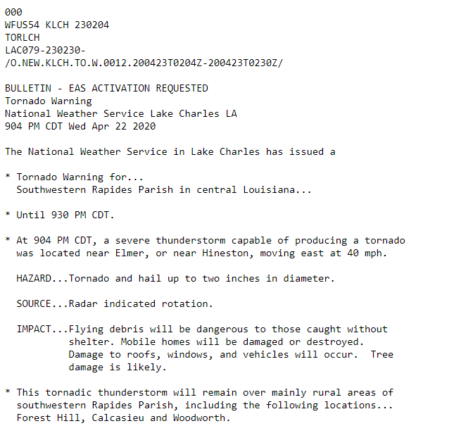
Gotcha. It looks like the storm was continually TOR warned since 9:04, but whether the polygons were inadequate is another issue.
-
26 minutes ago, MUWX said:
Alright. Wtf Is lake Charles doing. This is mind boggling
For everyone ragging on LCH, I noticed some problems with warnings not displaying in RadarScope this evening. For instance, the post above questions LCH's lack of warning around 9:25 or 9:30 PM, but there was a warning issued back at 9:04 PM. I thing something screwy was happening with the warning polygons (at least in RadarScope).
-
3 minutes ago, Allsnow said:
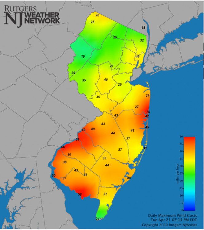
Yep, looks like the slght risk was for hail more then anything else. Winds were between 35-50mph. Obviously waiting for see what happen in the Bronx
This was a wind-based slight risk. Pretty strong gusts at some NJ sites, including 76 mph at Sea Girt, 66 mph Logan Twp., and 3 other 50+ mph gusts.
-
 1
1
-
-
8 minutes ago, NJwx85 said:
I disagree, normally you want to see 925mb temps below freezing to get sleet. In this case the column is above freezing except for the lowest level.
It's below freezing up to around 850.
-
1
-
-
31 minutes ago, CoastalWx said:
Radar has over 10-11” estimated SW of ILM and may be underdone.
Getting a few CoCoRaHS reports this AM. The 14.25" is as of 8:30 AM and apparently may be an underestimate as the gauge was totally full at measurement time. Not sure where this lies in relation to the USGS gauges, but at least makes their totals more plausible.
-
4 minutes ago, Eskimo Joe said:
Use caution with the USGS rapid deployment gauges that are listed. They use tipping buckets and are likely being affects by the wind, therein produce artificially higher rainfall amounts.
Tipping bucket gauges tend to be biased low in heavy rain events. Is there some aspect of these gauges you're aware of that would cause this? Or wind-induced tips?
Edit: Just saw the post above about the wind effects.
-
2
-

Tuesday but primarily Wednesday potential pockets excessive rain-wet microbursts Wednesday 2PM-10PM
in New York City Metro
Posted
Hey Walt (Mat from the ONJSC). Saw this yesterday.