
mgerb
-
Posts
239 -
Joined
-
Last visited
Content Type
Profiles
Blogs
Forums
American Weather
Media Demo
Store
Gallery
Posts posted by mgerb
-
-
1.9" in Somerset upon the changeover to rain (which occurred with no sleet or indication on correlation coefficient). Pleasently surprised as was mainly expecting a dusting or maybe a few tenths.
-
 1
1
-
 1
1
-
-
3 minutes ago, SACRUS said:
Great question as the normal sites havent reported rainfall since Friday. Mabe they'll update soon. New Brunswck site is also down.
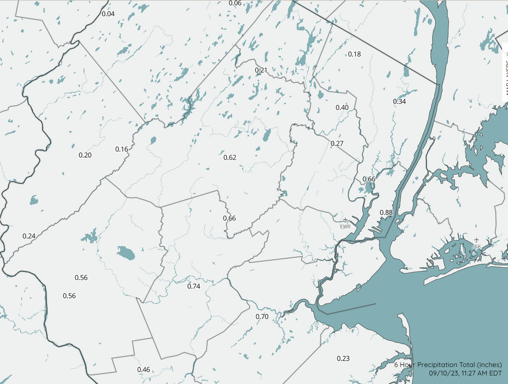
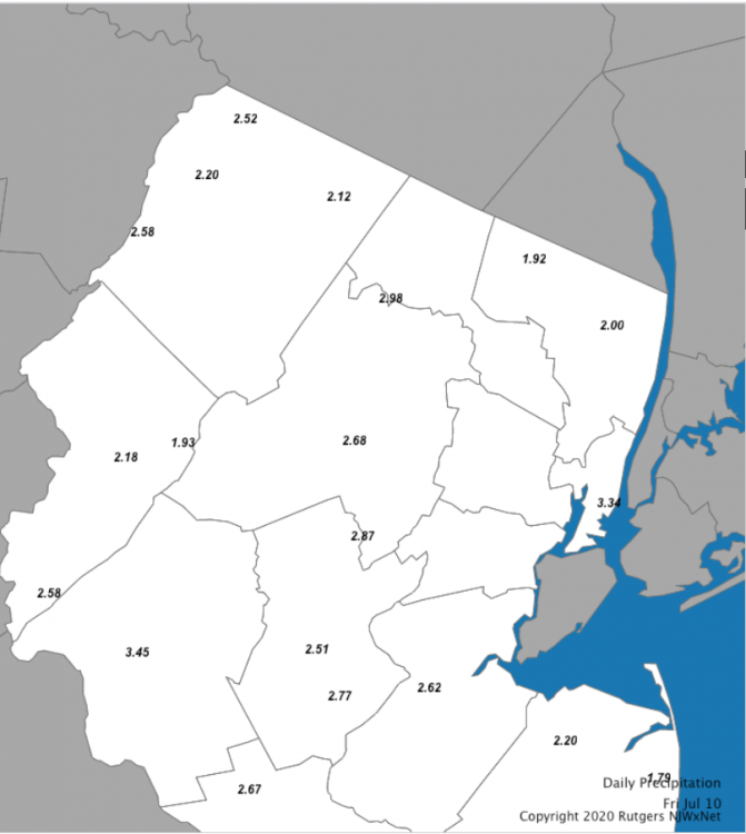
Not airport sites, but there are brand new 1, 3, 6, and 24 precip maps on the new NJWxNet map page here: https://www.njweather.org/maps/
Just select the desired maps in the "map layers" sidebar. Here's 6 hr precip. Over an inch at my home in Somerset from this morning's rain:
-
1
-
-
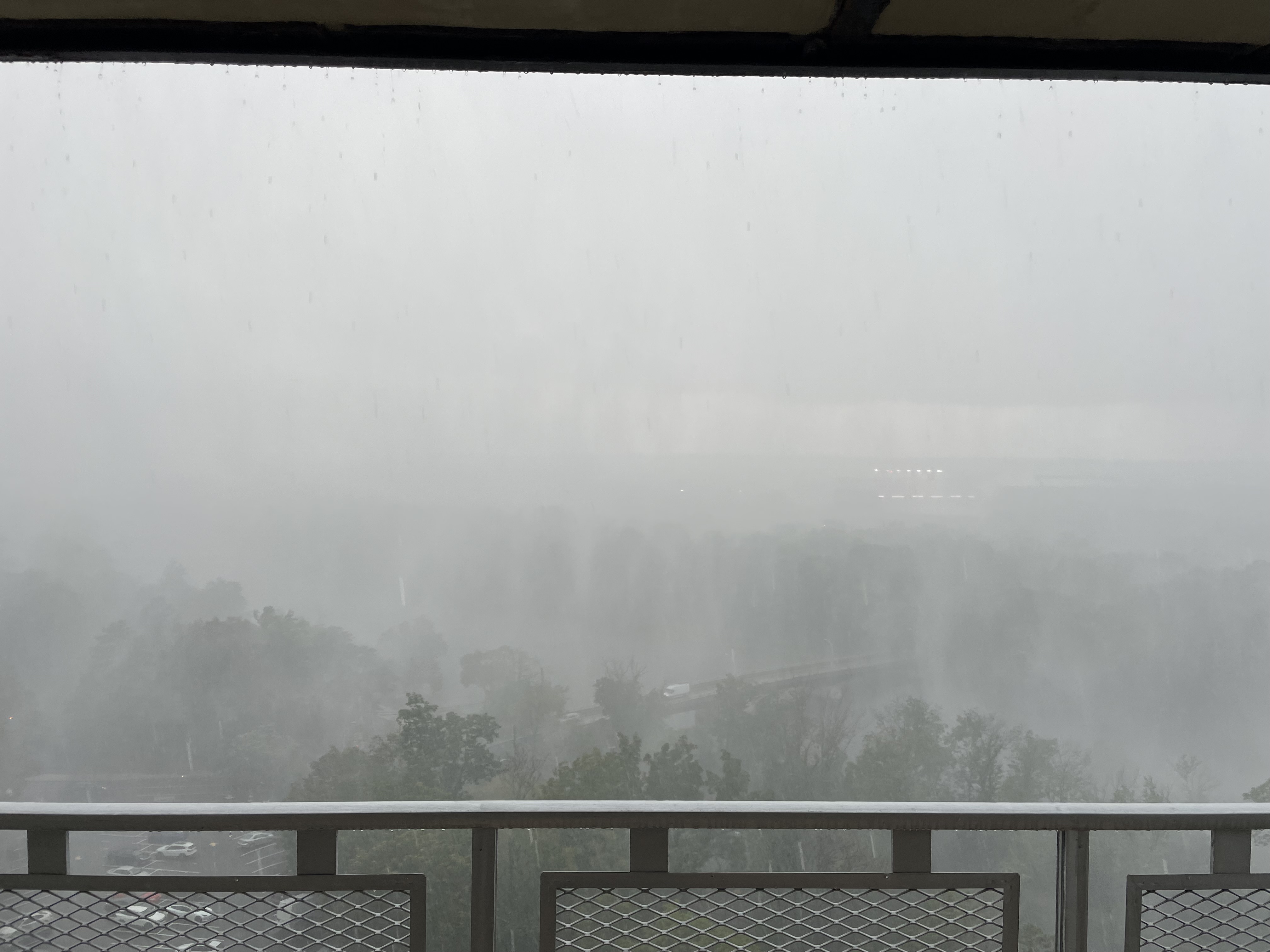
5 hours ago, Will - Rutgers said:
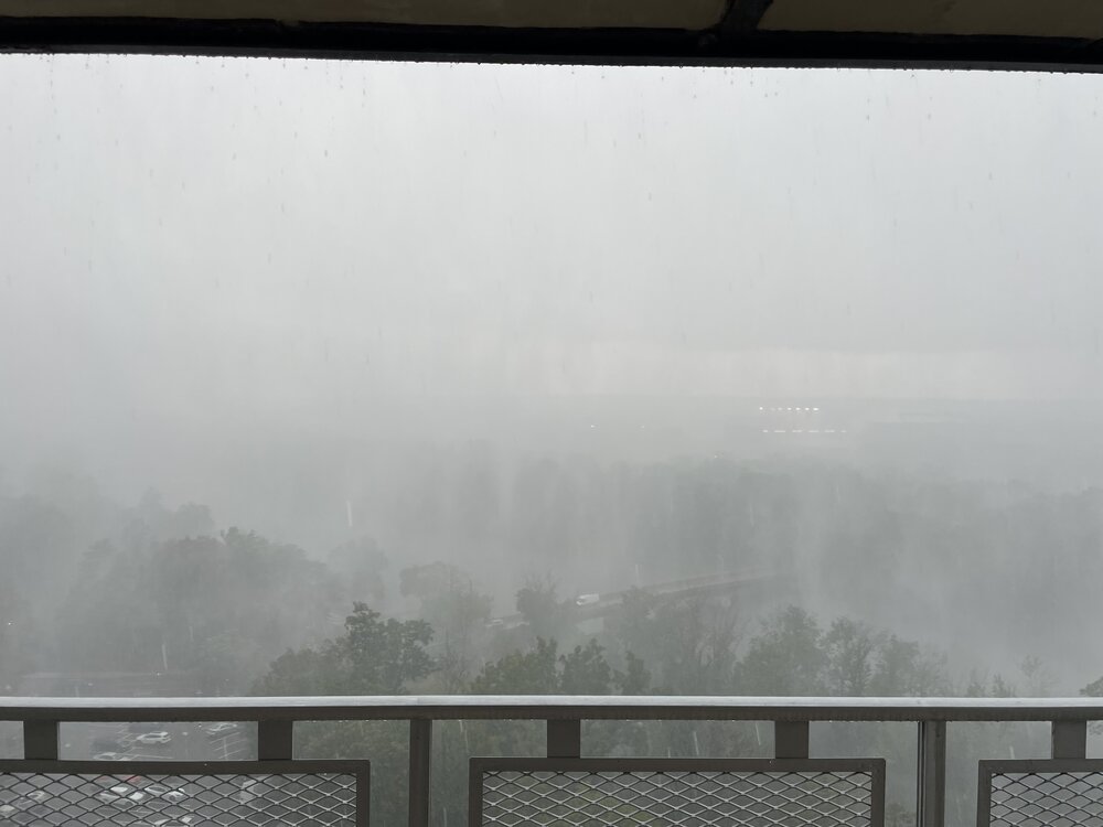
Hey, I know where that is! That's Landing Lane bridge, right? Just a few miles from me. Was just thinking how awesome it would be to watch today's storm roll in from the southeast way up in one of those buildings. Anyway, strong winds here too (sporadic downed branches), and 5+ minutes of hail, though most was rather small (smaller than dime from what I could tell). Around 0.70" in the bucket. Fun storm.
-
1
-
-
38 minutes ago, doncat said:
What type of equipment do they use at those njwxnet stations if you're familiar? I assume it's just observers with their own pws.
Yup, I'm familiar. I work in the state climate office and sometimes help service the stations. It's mostly a mix of Campbell Scientific EE181 and HC2S3 (more of the former). Then there are 14 stations that use Peet Bros equipment, which is more akin to backyard-type weather stations. With one exception (Harrison) and aside from the Peet Bros stations, we don't pull in any PWS data. We also bring in other professional networks, such as ASOS, AWOS, RAWS, some USGS, and a few others.
If you go to any station page (e.g., Little Falls here), near the bottom of the page you can see photos of the site and a list of installed equipment.
-
4
-
3
-
-
3 minutes ago, doncat said:
Problem with alot of the pws with the sun shining on the shield....aspirated is the way to go but they are expensive.
I have a Davis Vantage Vue that reads high too when in full sun. Non aspirated, and well over 10 years old, so that may be part of the issue, but has read high for as long as I remember.
But regarding aspiration, not a single temp/rh sensor (66 in total) operated by the NJWxNet is aspirated, but they don't have that problem. Aspiration is good, but not essential; perhaps has more to do with sensor design or just a biased sensor.
-
4 minutes ago, mgerb said:
Can see the surge occurring right now.
Getting pretty bad. This was not underwater 5 mins ago. https://www.mysanibel.com/live-street-cams?utm_campaign=SanCapChamber&utm_medium=referral&utm_source=SanCapChamber
Periwinkle and Casa Ybel West. Very strong gusts too.
-
15 minutes ago, SchaumburgStormer said:
Periwinkle & Casa Ybel West
Can see the surge occurring right now.
-
1
-
-
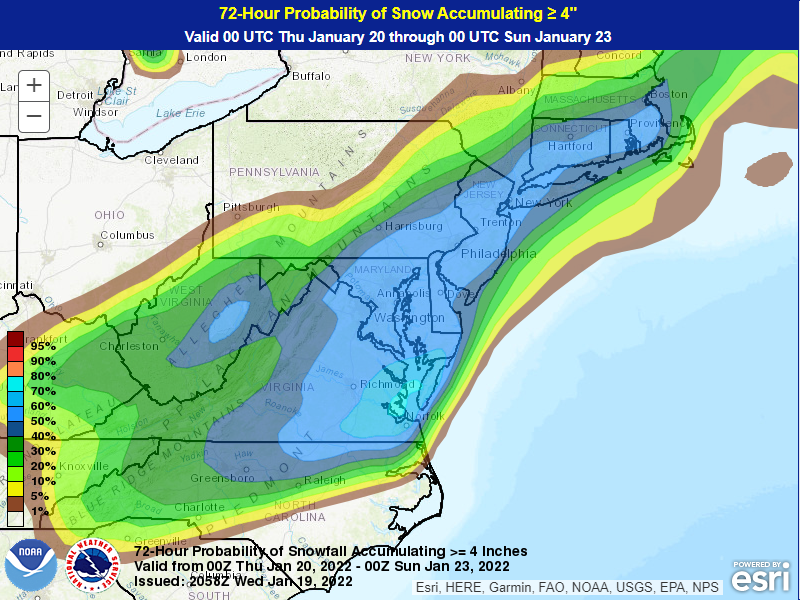
-
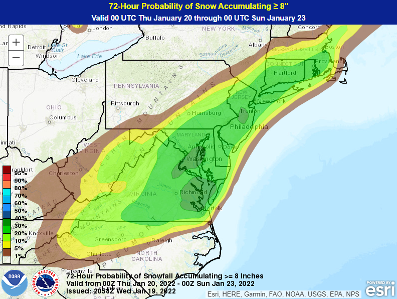
Did I miss something? These probs seem insanely high.
-
17 minutes ago, wdrag said:
Wow... not sure when that changed? I do think this will suppress amounts do to settling, drifting. Up through March 2018, it was clear the board every 6. Anyway, you're saying 24 hrs... that's what it is. Thanks! Walt
That guide actually came out in late 2013. Maybe some WFOs disseminated and adopted more strictly than others.
-
2
-
-
49 minutes ago, NorthShoreWx said:
I've been doing the max depth thing, although I will wipe a board once a day in the AM , even during a continuing storm. That's the number I provide in spotter reports. I double it for posting here.
To be fair that doc leaves open the possiblity for 6 hour wipes (i.e., at airports), so the issue remains confusing, I'm not sure if it is the latest and greatest however.
You're doing it perfectly right. This is the same that we advocate in CoCoRaHS (I coordinate the NJ program). And yes, also doubling for posting here.
-
3
-
 3
3
-
-
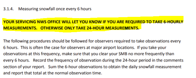
19 minutes ago, wdrag said:
Typically CO-OP stations and CoCoRAHS sites measure 1x/day...max depth on the board since the prior morning ob.
However, more accurate snowfall that limits settling-drifting etc is taken every 6 hours with a snowboard wipe.
Snowfall:
Measure and record the greatest amount of snowfall that has accumulated on your snowboard (wooden deck or ground if board is not available) since the previous snowfall observation. This measurement should be taken minimally once-a-day but can be taken up to four times a day, (every 6 hours) and should reflect the greatest accumulation of new snow observed (in inches and tenths, for example, 3.9 inches) since the last snowfall observation.
Here's the link. https://www.weather.gov/gsp/snow
Hope this helps. Walt
I'd just add that this page is a bit outdated, since it allows for 6-hourly board clearings. Current NWS guidelines have removed that option, unless specifically requested from your local WFO (e.g., airport stations). See pages 6-9 here:
https://www.weather.gov/media/coop/Snow_Measurement_Guidelines-2014.pdf
-
1
-
2
-
-
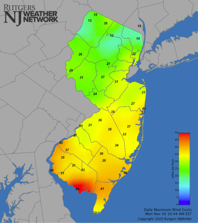
3 minutes ago, wdrag said:
Logan Township extreme sw NJ 50 kt ~950A> NJ Climate station
50 mph. All, you can monitor those here (note: problem with maps displaying on Chrome; other browsers should work): https://www.njweather.org/maps/nj-statewide-wind-gusts-daily-max
-
1
-
1
-
-
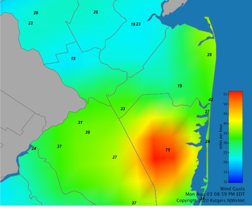
9 minutes ago, wdrag said:
TOMS River from a thunderstorm peak G 61 kt at 751P KMJX 032353Z AUTO 25041G61KT
JFK 45 kt right now.
75 mph at Berkeley Twp, which I think is co-located with the Toms River AWOS at Miller Air Park. So they definitely corroborate each other.
-
1
-
1
-
-
1 hour ago, wdrag said:
Also for those using radar rains... I checked OKX and DIX estimates... they were too significantly too low in the east-west axis just below I78 last night. I its safe to say 3/4"-2.75" fell in that band last night (CoCoRAHS, WXUNDERGROUND and RU climate sites). It drains but soil remains a bit moist for whatever happens tomorrow night, then late Sunday svr risk, then the tropics, if its still on NHC track.
Can confirm. I was the 2.76" CoCoRaHS in Somerset. 10.31" for the month.
-
1
-
-
Absolutely slammed here. Picked up about 2.30" in 45 mins, and 2.60" in an hour. Pretty intense winds (would estimate at least 40-50 mph gusts) that continued for a while. Max rain rate on my Davis of 14.05"/hour, which I think is by far the highest I've ever seen. Definitely an upper-echelon storm among those I've experienced in my 39 years.
-
8 minutes ago, Allsnow said:
Got it! Thank you. Your area got slammed! How much rain did you get?
Got around 1.10" from last night's storms, and 1.33" for the day. 7.43" over the past 18 days. But couldn't buy a raindrop for the 30 days prior (0.35"). Summer rainfall is so fickle.
-
1
-
-
2 minutes ago, Allsnow said:
Thank you. But when I hit play nothing shows up. Is that something on my end?
Not sure. Works for me. Can try this too:
https://www.dropbox.com/s/vowbpumt4dt0cjc/2020-07-24 02.45.47.mov?dl=0
-
1
-
-
2 minutes ago, Allsnow said:
Anyone have a radar shot from last night? The southern part of my county got a ton of rain overnight !
I took a loop centered on my location, but close enough to you to see much of it.
-
1
-
-
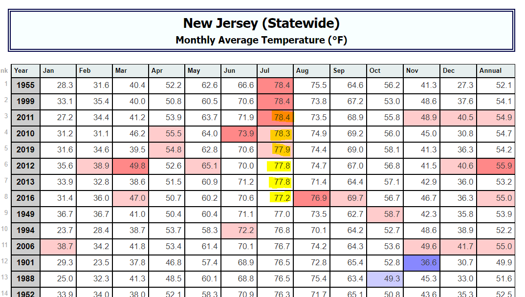
4 minutes ago, forkyfork said:
6/10 of the hottest julys are from the past 10 years
Soon to be 7 of 11. http://climate.rutgers.edu/stateclim_v1/nclimdiv/index.php?stn=NJ00&elem=avgt

-
2
-
-
1.54" from this evening's storms. Sub-severe imby, but a short period of gusty winds of maybe 35 mph. Very satisfying.
-
6 hours ago, SACRUS said:
The New Brunswick (Rutgers) site hasnt updated since 1900 last night. Not sure if anyone on this is affiliated with that site and has any update. It does happen time to time.
Not sure what's up with the Met department page, but we're still bringing in the data through our NJWxNet site. So you should be able to find what you need here!
-
2
-
-
1 hour ago, Animal said:
1.3 final...maybe rain was harder locally etc
How bizarre. *shrug*
-
2
-
1
-
-
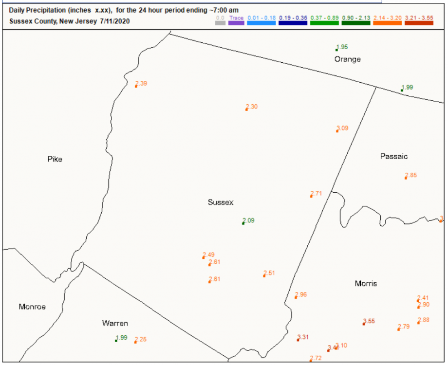
3 hours ago, Animal said:
Update
1.1 of rain
Still at just 1.10" this evening? There's a bunch of gauges in the NJWxNet up your way with 2"+, and I definitely don't doubt what you measured in the plastic 4" gauge (I coordinate the program out of Rutgers; those gauges are top notch). The 2.52" is at High Point (not all the way up, but 1388'), and the 2.12" is our brand new station at the top of the main lift at Mountain Creek (~1394'), which I believe is pretty close to your location? Both are quite similar in elevation to yours, so doesn't seem to be a topographic thing. I'm really surprised by the difference and curious to see what other reports in the area show tomorrow.
-
3
-
1
-

.gif.53baf181082e20639b68f60741d982ae.gif)


Snow Friday 1/19/24: is it a period of light snow (less than 2"), or is there a chance of a 5" swath in part of the NYC subforum? Event OBS.
in New York City Metro
Posted
Dumping pretty good under this band on Somerset. Very fluffy, high ratio. Less than a half inch so far, but let's see this can stick around.