

delgto04
-
Posts
46 -
Joined
-
Last visited
Content Type
Profiles
Blogs
Forums
American Weather
Media Demo
Store
Gallery
Posts posted by delgto04
-
-
Mt. Holly still bullish:
Morning Update... We are entering a general lull period for most of the region. Morning convection, some of which became strong to severe along the warm front, has moved offshore. Steady rain continues across the north, but precip rates will remain manageable through this morning. Overall, there is not much change to the forecast. Did tweak the PoPs a bit to capture more of a lull in southern areas this morning and early afternoon. With the way this system has wrapped up, we`re likely in for several hours of mostly dry weather along and southeast of the I-95 corridor. But with time, rain will fill back in. The severe weather potential for later today also appears very much on track. The warm front is clearly evident, and shear and forcing will be strong in its vicinity later today. In addition, we`re even seeing some breaks of sun across the far south and may see more into early afternoon, which will only serve to increase instability. All in all, still looking like a high impact event. -
39 minutes ago, high risk said:
I'm in on SVR. I'm not in on widespread flooding rains until you get further north and northwest, although there will be isolated local flooding where recent heavy rains have occurred.
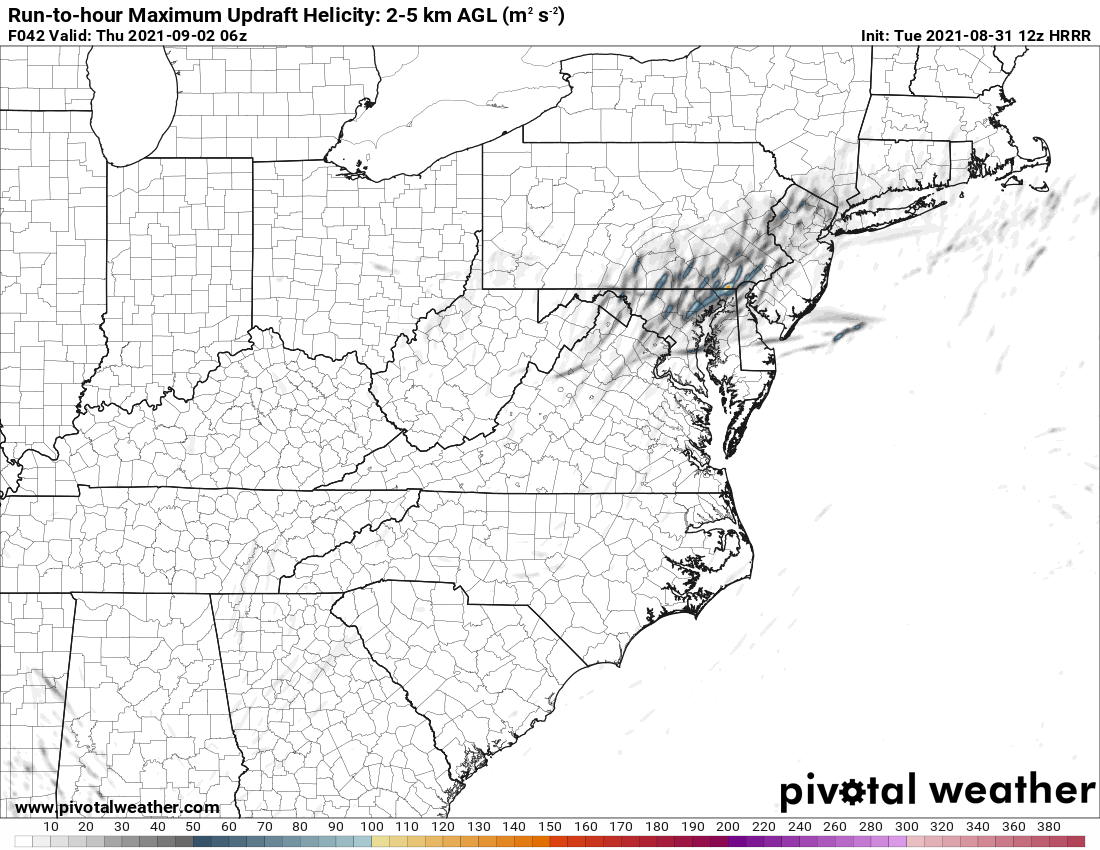
Right now, guidance shows most of Wednesday being dry which will allow for some heating for sure. We then get some bands of convection arrive later in the day, with perhaps some moderate instability and likely strengthening low-level wind fields. If some of the more aggressive guidance is correct, these won't be little spin-ups in a big shield of rain; these will be legitimate supercells embedded in intense convective bands. This UH image from the 12z HRRR would warrant a potential ENH for tornadoes:

There are plenty of ways that this could fail, and we often fail here, but this setup has *potential* to be a big deal if we legitimately heat up tomorrow. As for the rain, there could be some sneaky higher totals tonight, and those bands tomorrow evening will have torrential rainfall, but the heaviest rain will overall be too progressive, and the periods of intense rain will overall be relatively short-lived until you go further north.
Hope not. Isaias was a little to close for comfort in my neck of the woods.
-
3 minutes ago, Wetbulbs88 said:
Just took the pups out for a very long walk. Still some slush, especially in the deeper puddles, but shallower pools are freezing fast. If I hadn't been wearing my hiking boots which have good grip it would've been a back breaker. One guy was shoveling his sidewalk, and I don't think he realized he was only making it worse; there was already a significant layer of ice forming in place of the sleet.
Agreed. Many out shoveling today but don't realize that there is better traction just leaving it be.
-
 1
1
-
-
29 minutes ago, Eskimo Joe said:
Watch the activity on the back end turn everything into an ice palace tonight and we somehow trip into an ice storm.
Never know the way things have been going. This is the reason why I am not bothering to shovel this sleet mess. Just gonna be a sheet of ice later and may as well wait with temps expected above freezing tomorrow. Not going anywhere anyways and easier to walk the dog on the crunchy stuff.
-
24 minutes ago, frd said:
@MillvilleWx perfect call !
This one would make us happier after the last one for sure.
-
Flakes mixing in now finally in Townsend, DE!
-
1
-
-
2 minutes ago, frd said:
I am still expecting some additional snow tomorrow.
Promise?
-
Thinking my area is gonna get (not) screwed. Not getting anything on the front or back end.
-
29 and wimpy light flakes in Townsend, DE. Hoping this picks up eventually.
-
35 here in Townsend, DE. Few high cirrus but mostly sunny with a breeze. Counting down.
-
1
-
-
My forecast for the Obs thread on this event is over 100 pages beginning Sunday. Just curious as to what this system is classified as now. Would this be Miller A or a hybrid B?
-
Just now, ers-wxman1 said:
Miller B storms are just plain complicated. No way around it. Anytime you are relying on a transfer of energy from one system to another aligned along a baroclinic zone you are asking for trouble at this latitude. The 500 trough is not all that impressive and there are a number of other factors involved to make this work. I think the model envelope is shrinking but it’s those finer details that still need to be worked out in the next 48 hours that count. These track and snowfall maps will change everyone run.
This! We have been through these scenarios countless times.
-
9 minutes ago, ers-wxman1 said:
The 500mb pattern depicted on the ENS is close to something big but not quite there yet. The best look the Mid Atlantic has had in two years, but ideally we need the western ridge more amplified and further west with the 500 low deepening and closed as it passes south of us and off the coast. Tilt going more negative and a phase to cutoff and keep the CCB going. It’s close, but not quite there yet. Fortunately we have cold high pressure over southern Canada vs that upper low which suppressed the Thursday system.
Given trends this year, if we continue to see the ECMWF holding the pattern into 72 hours from onset with the ukmet and icon following along we will be in a favorable trend. These models have been consistent in showing the suppression patterns, more conservative. Coastal transfer time and deepening is crucial with Miller B type systems. If the Midwest low is too strong the transfer gets delayed and not favorable per GFS. Hoping for a win for this forum. But, let’s also keep in mind that the pieces to the puzzle are all being simulated at various points...some outside the U.S. so swings and uncertainty will be factors this far out. I think by Thursday there should be much better consistency and a better picture of where we are headed with this. Just my two cents.ERS
Always respected your analysis and glad to see you posting. I check in a bit but this one has my attention.
-
1
-
 1
1
-
January 28-29, 2022 Miller abcdefu Storm Threat
in Mid Atlantic
Posted
Snow aside, Are we looking at possible power outages from winds on this. It appears that we should expect wind advisory or warnings at and just inland from the coast.