

CTFarmer
-
Posts
32 -
Joined
-
Last visited
Content Type
Profiles
Blogs
Forums
American Weather
Media Demo
Store
Gallery
Posts posted by CTFarmer
-
-
7 minutes ago, dendrite said:

Triple-bunner.
Rhymes with "nipple laser"?
-
 1
1
-
-
Took a quick survey in a large corporate office and many more people were aware Brittney Spears might have slapped someone than who knew we had a hurricane watch. I think much of SNE is going to get caught flat-footed on this one.
-
 1
1
-
1
-
 1
1
-
-
LIS storm urge impact with multiple tide cycles compounding will be an issue, especially western sound.
Aside from those who make a living on the water, most residents are totally unaware of this incoming for the weekend.
It does not take much. It only drains through the race or under the Brooklyn Bridge.
-
Effectively three days to get a lot of boats out of inshore moorings in LIS, in peak summer.
-
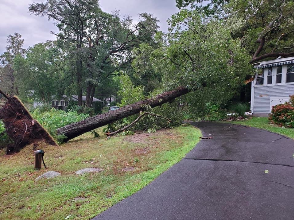
I got a better survey of Leete's over the weekend, as we cut through blocked roads and the utility guys finished-up. Some trees we could not remove due to pending insurance claims and/or just need a crane.
I'm no expert, but I will definitely agree with evidence of straight-line winds. All trees downed from northwest to southeast.
Where there is damage, it was like a bulldozer tried to make a new road for 50-100 yards, all in the same NW->SE orientation.
Trees affected were big ones, like this massive old Hickory that probably survived 1938.
Definitely a memorable storm. Very thankful no one was injured.

-
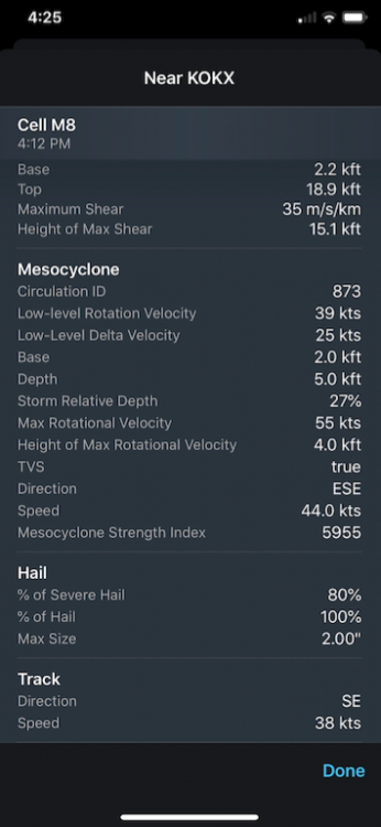
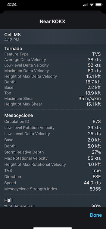
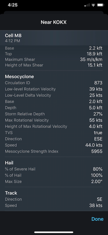
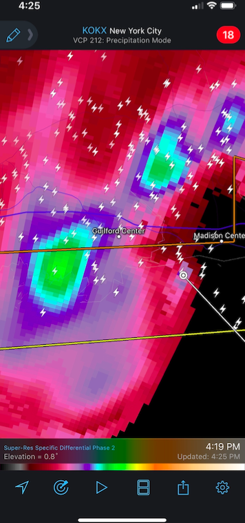
6 minutes ago, CoastalWx said:
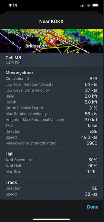
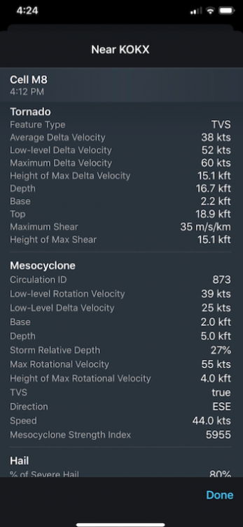
Where do you get that detail for the mesos, hail etc? Is that an additional subscription on Radarscope?
Just the "Pro Tier One" subscription.
When there's a message icon on a storm or warning/watch box, the mesoscale event details are there.
-
2
-
-
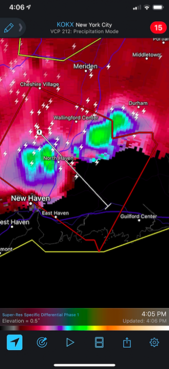
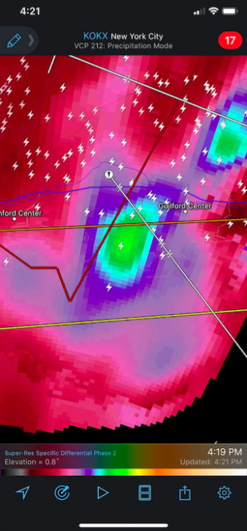
Dump of screenshots during the event:

-
2
-
-
2 hours ago, BrianW said:
That video is EXACTLY what it was like.
Just got back from Leete's Island, basically was cutting paths through trees last night so people could get out. Utility guys were swarming when I left this morning.
One neighbor's cottage smashed, one car smashed. Water-facing windows blown-out in numerous cottages.
Thimble Islands (to the northwest) are storm-hardy, but I know Money Island has severe damage.
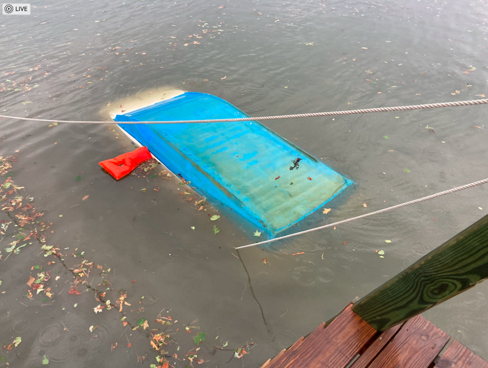
And got my little boat out of the water last night, but here it is right after getting flipped.
It's only about 12" above the water line and about 1000 lbs total with the motor. The wind managed get under it and flip it.
-
 1
1
-
-
That's amazing-
19 minutes ago, Ginx snewx said:@CT Rain hmm
Weird observation- at about 6pm (an hour after the main storm) the water in Leete's Island Bay was surging in/out every 10-15 minutes about 12 inches (not exaggerating). Happened three distinct times, then subsequently faded.

Ha- that's crazy (or rather I'm not crazy). I checked the mid-sound buoy for observations, but naturally its offline.
I'm super-curious if this is water pushed from the storm(s) and it was sloshing around Long Island Sound.
-
I have a place on Leete's Island in Guilford and that was more damage than Sandy or Irene. A fine plastering of vegetive matter on windows and screens. Lot of extremely well-weathered and very strong trees down. My dingy tied to my dock was flipped-over, had to recover it while the tide was high and some daylight left (save the 5hp motor!). Weird observation- at about 6pm (an hour after the main storm) the water in Leete's Island Bay was surging in/out every 10-15 minutes about 12 inches (not exaggerating). Happened three distinct times, then subsequently faded.

-
5
-
-
16 minutes ago, Damage In Tolland said:
Nice!! And that's on the farm too. Great stuff
Actually, this is the home base back yard with 50/50 shade/sun where I mounted the PWS sensors (for balanced sampling).
In the fields, I'm certain it is brutal.
Just hit 99 even. Breeze has kicked-up a little, that helps make it tolerable.
My day job is in State House Square in downtown Hartford, I'll figure out just how hot is it when I walk out the lobby in a few hours.
-
2 hours ago, Damage In Tolland said:
99-100 is possible today at CEF/ BDL.. maybe Merrimac Valley
Hit 98.4 on my PWS at 11:41am.
https://www.wunderground.com/personal-weather-station/dashboard?ID=KCTEASTH34


Powerful Multi-regional/ multi-faceted east coastal storm now above medium confidence: Jan 29 -30th, MA to NE, with snow and mix combining high wind, and tides. Unusual early confidence ...
in New England
Posted
Feb 2013 blizzard here in CT. Would be cool to rival it.