
davenc
-
Posts
163 -
Joined
-
Last visited
Content Type
Profiles
Blogs
Forums
American Weather
Media Demo
Store
Gallery
Posts posted by davenc
-
-
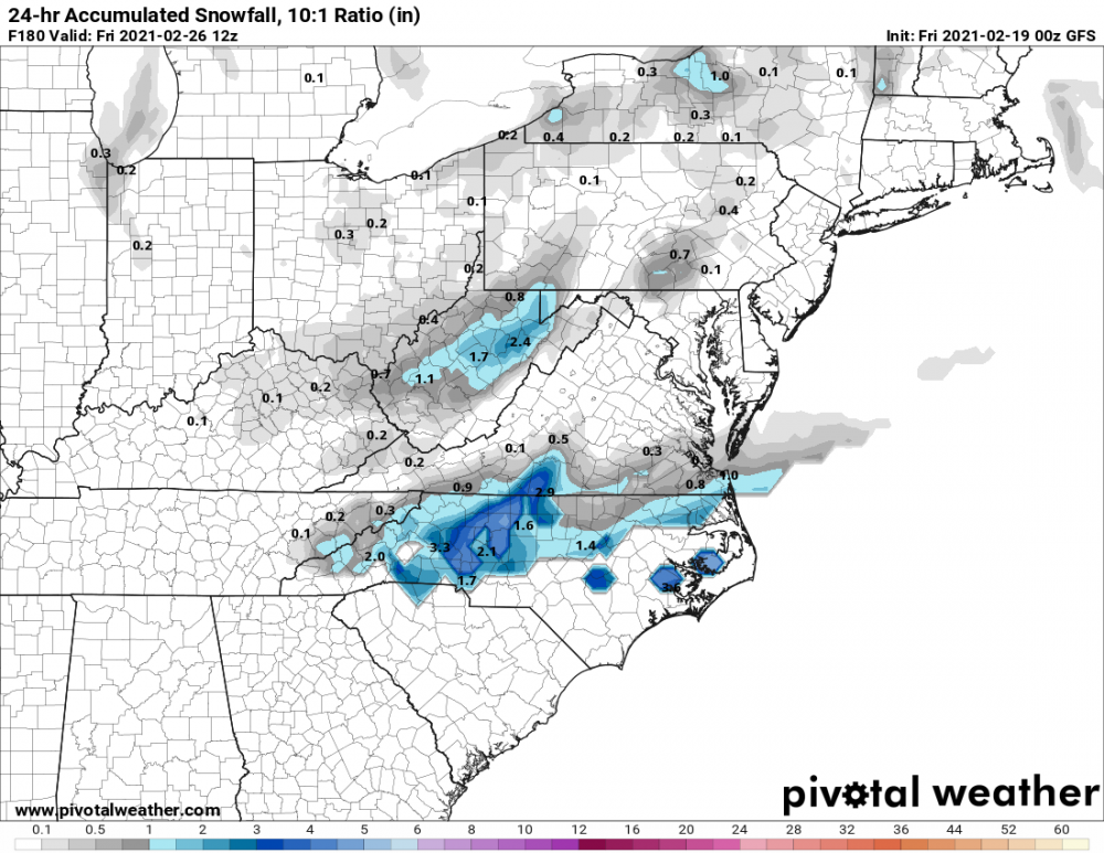
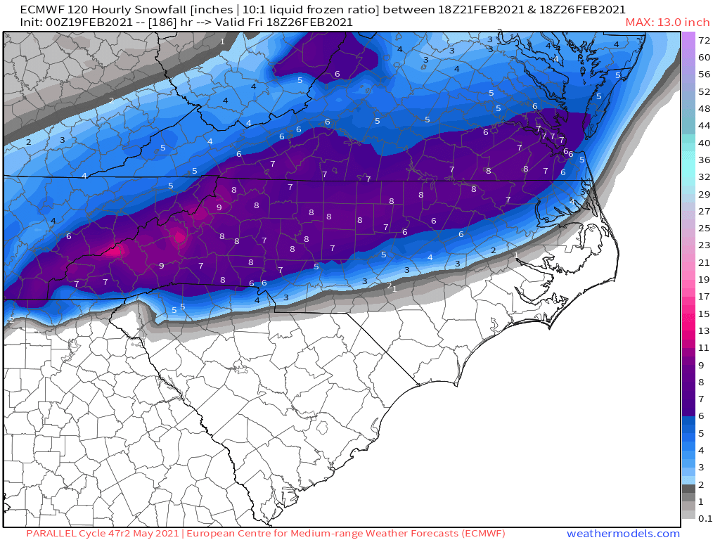
The state is becoming more and more covered with precip! Wake up and give us your OBS !!
Concord.
35.6/31
Rain continues!!
-
Concord
37/27dp
Rain is falling.
-
20 minutes ago, Jmoon said:
Just walked outside. 36.0 With Light sleet and flurries mix right now in SW Rutherford county. Didn't even see anything frozen the other day in the winter storm warning. This is a nice little surprise. Be interesting to see what happens when the heavier precipitation arrives later tonight.
Thats awesome to hear!! Keep us updated!
-
28 minutes ago, PantherJustin said:
Serious question, if you had 3 options
A) one 24-30” Storm with temps in teens and blowing snow but afterwards had a 3-5 yr SN DroughtB..) One 10-15” Storm and then a 2/3 yr drought
c) Consistently 4/5 3-5” events per year but never more than 8” for a decade.
B
-
 1
1
-
-
3 minutes ago, NorthHillsWx said:
Is this not the exact same time it snowed last year with almost the exact same look...
Dont know, but Charlotte has now gone over 800 days since our last 1" snowfall. '<(
-
 5
5
-
-
48 minutes ago, BullCityWx said:

I will not get excited, I will not get excited! (Doing back flips in my mind!!)
-
15 minutes ago, NCSNOW said:
Both 0Z Gfs back on for next Thurs/Fri
Even the N Charlotte metro sees some action! Bring it.
-
2 minutes ago, kvegas-wx said:
Some awesome icicles on those cameras! But overall the highways look great.
Right. 52 at University in far NW forsyth looks icy, and some bridges here and there, but yes, overall the majors look to be in good shape statewide!
-
For all the SUPER weenies, check out CAMS , turn on the ncdot traffic cams, and see what has unfolded(or not unfolded) across the entire state!!
Enjoy!!
-
1
-
-
6 minutes ago, PantherJustin said:
1/10” here in Mooresville but I think that’s about gonna be it....JOKE
I wouldn't say so just yet. This storm still has some juice left!
-
Concord
32/32
Wind Chill is 16
Just a raw rainy mess.
-
Concord
34
Dp 32
Rain
-
7 hours ago, ILMRoss said:
Don’t want to get anyone’s hopes up.
But as this trough finally clears the coast later this week, Friday afternoon/evening could end up being a sneaky little snow chance if our friend, the northwest trend, shows up to amp this impulse up and drive precipitation further inland.PLEASE get my hopes up!!!
-
23 minutes ago, PantherJustin said:
44/25 in Mooresville not sure what I was Shown on NAM currently. I still stick with my idea the Ice line will halt on HWY73 up to HWY152 somewhere in there South of there I doubt goes below 32/33 at all N of there 31/32 Includes Huntersville- Concord/Kannapolis up To China Grove - Mooresville ..... Point blank you all know your area and how it performs in CAD , If you normally hold longer you will tonight as well if not you won’t. Climo and history will repeat itself more times than not. Someone tell me if I’m wrong on that though
Im between 29 and 49 in sw concord! I hope your right about 73 being the line! Sleet I'm ok with, the other can kiss m......
-
Concord is READY for this ghastly winter to continue!
Currently 46
Dew point 25
But, im still optimistic that I will see my avg of about 4-5" of snow before spring!!!-)
-
38 minutes ago, Avdave said:
Taken by Kendall Clanton. This is I 85 near DeWitt, VA today. Having driven this stretch many times, it is loaded with Pine Trees on both side of the interstate

It is THE wors t stretch of interstate ive ever driven. Yes so many pine trees right beside the interstate creates this gauntlet effect! But i dont wish this ice storm on anyone. Prayers for safety!
-
Im about to throw the towel in here in Concord. Its 34 and fat rain as well. Ugghh
-
Live YT cams in Clayton, Smithfield, and Apex are showing snow falling!
Can anyone verify or is anyone seeing snow mixing in??
-
3
-
-
The drivenc site for all things NC road related showing 2 crashes in W-S and 1 in GSO.
Also noticed that Wake county has 11 ELEVEN road construction zones while Meck County has..... wait for... oh whatever,,, THREE construction zones.
Whoever says NCDOT isn't partial to the triangle needs to check out the 485 inner loop on a friday from 330-630pm. From Independence to 85 near the airport and the Catawba River. Thats not quite HALF of that 63mile loop... enjoy.. and bring food.
Ok road rant over.
-
 1
1
-
-
Dropped to 32 in Concord about 30mins ago
DP also 32
Quite misty atm.
Heavier precip is N of me, but some patches of showers moving up from SC.
-
Concord sitting at 33 with a dp of 31.
Accuweather has the low tonight at 33. We have been about 4 degrees below forecast temps all day. No ice yet.
-
4 hours ago, tarheelwx said:
I think it has more to do with Wake being such a large county. The WWA makes sense in the northwest part of the county, but not so much in the southern part. However, it is fairly uncommon to split a country for winter advisories and warnings.
TW
Same in Mecklenburg.
Very common when it actually snows for S.Meck to see an inch or two, while uptown sees 4, and up in Davidson on LKN they get 6-8" . Iredell is even worse.
-
Concord
37 F
36 DP
N wind at 11mph gust to 16
Heavy mist
The way the wind is blowing this mist around sure does remind me of philly nor'easters!!
-
1 hour ago, FatherNature said:
What happens to the message board when we end up with 3 rain storms through next week and not one flake?
Im already meditating and practicing "acceptance"

February Observations Thread
in Southeastern States
Posted
Rain /Sleet mix in SW Concord!!!