J Paul Gordon
-
Posts
1,750 -
Joined
-
Last visited
Content Type
Profiles
Blogs
Forums
American Weather
Media Demo
Store
Gallery
Posts posted by J Paul Gordon
-
-
So when has the climate NOT been changing? We are in a warming spell. A significant amount of it is human driven, some is probably a natural thing. In my grandson's lifetime we'll probably be moaning about the pinwheels and fields of glass scaring the countryside and using fusion, hydrogen, and who knows what else to drive our vehicles and supply our power. No one can be absolutely sure how long it will take the oceans to absorb the excess CO2 and when we'll enter a natural cooling spell. The long and short of it is that the ice will someday come back (most likely a lot of lifetimes from now) and then it will melt and sea levels will rise, etc., etc., etc., ad infinitum. The climate keeps changing and the weather is fickle. Let's enjoy the show.
Would I like to see some real 2015 like snow stretched over an entire winter? You bet! But I'm not going to whine about a beautiful 50F day with the low winter sun and long shadows under a perfectly blue sky. Maybe I'm just getting old and with a limited number of years to go, everday is good enough.
Let's hear it for Christmas, white or green, and its message of hope born in the least expected place and least convenient time.
-
 4
4
-
 2
2
-
 1
1
-
-
May you be at the hypocenter and me on the farthermost outer edge of it. Of course, your neighbors (and your near and dear) may not feel as blessed as you with hurricane force gusts.

-
1 hour ago, Typhoon Tip said:
06z GFS centered on 12z DEC 19 - any gullible takers ?
Me. I'll take it. Smack in the middle of some of the best snow.
-
1
-
-
2 hours ago, weatherwiz said:
January and February…into some
of March that’s when our snow is. All this crap about December snow and “white Christmas”…is just that, it’s crap. It’s just mentality deranged from childhood fairytale stories of Santa recruiting Rudolph to guide the sleigh through snow and fog.
The original Rudolph guided Santa through fog, not snow. Guy who wrote it was supposedly inspired by a thick fog in NYC. Lots of stories about Robert May's inspiration in 1939, but that is one of them. So, yeah, let's stop with the "White Christmas" mania, especially here in SNE. Up north, its a different story, but fog and rain are more common down here. Let's start dreaming of a Wild Sou'wester on Christmas Eve.
Sincerely yours, The Grinch.

-
2
-
-
50F high today 28 low. Looks like a wild ride tomorrow night into Monday. Would be nice to see a few flakes at the end of it, but not putting much down on that.
-
Snow in the late Christmas Eve Day into Christmas night range in interior SNE. (Not for the whole period unless we get lucky. Anywhere from a wet couple of inches to something more significant). Rudolph told me.
PS Average high temps here for the 10-15 December are in the 40-42 F range. Average high around Christmas is 37. So the AN outlook is normal to above but doesn't consitently hit the "torch" range.
-
Its November 10th and people are freaking out about an entire winter ahead. Some things never change. One of the reasons I love this Board.
-
1
-
-
High of 36 Low 33. A raw November day here.
-
1
-
-
Where is the "torch" people were talking about? And what constitutes a "torch" in November. Last year it got up into the mid 70's here more than once. I can understand that being called a torch. But is a 60F day in November a torch or just a sort of normal warm November day?
-
53 minutes ago, Damage In Tolland said:
We’ve been telling em’ there is a 3-5 day window Tgiving week .. possibly the holiday itself that pushes or even exceeds 70 . Signal is quite evident. Factor in it’s been Stein and dry the last month or so, no vegetation and strong zonal west downslope flow. Likely areas will overperform and furnace .Going to be ugly . We may possibly see folks roasting and basting turkeys in pans and aluminum foil on rooftops , roads , and driveways in the sun.
70-75 for most of SNE on T day. Higher in the CT Valley, a little lower in the higher elevations of the Worcester Hills. Real possibility of some 80 + readings. Mid 60's to low 70s for Christmas. No significant snow before Jan 15 if we are lucky.
Got up to 64 here today.
-
1
-
-
Any likelihood that we'll see the mid seventies we had last November? I remember hiking on a nice trail on Wattaquodock Hill on a day that felt like early September.
-
4 minutes ago, Torch Tiger said:
A reminder for the winter faithful
Toxic positivity is the pressure to only display positive emotions, suppressing any negative emotions, feelings, reactions, or experiences. It invalidates human experience and can lead to trauma, isolation, and unhealthy coping mechanisms.
I'm working on positive negativity this year. When someone says it will be AN, I'm going for historically (and hysterically) AN. This way we can confuse the weather demons into giving us just the opposite. On occasion, I'll get serious and listen to the real mets--who actually know what they are talking about.
-
1
-
1
-
-
Upper 80s in the Connecticut Valley on T day. Near 80 right up to the Canadian border. No need for further discussion. We are doomed.
-
1
-
 1
1
-
-
Dews remained in low fifties here througout this ordeal so it never actually felt hot.
-
36 minutes ago, Damage In Tolland said:
If you believe ensembles. 70 ish may happen 3-4 th week of Nov
I would absolutely believe them and add 5 degrees to it.
-
1
-
-
Hit 77 here. Glad to see it go. I'm sure November will have a slew of 25 degrees AN days, too. Feels nice and wrong at the same time--like snow in May.
-
1
-
-
When will the Torchvember thread be up?
-
6 minutes ago, Damage In Tolland said:
There’s the furnace now spitting out all timers

These the forecast temps here tomorrow? Hit 75 here today. Just about that warm on the Maine coast when we left Wells at 2:30. Temp dropped from 80 in Bolton to 74 here at Ridgefield just five miles west.
-
I'm going with the idea that if I say it will be a much above normal winter with almost no significant snowfall it will end up being cold and snowy. There is a psychobabbel term for this.
So, for the record, its going to be a well AN winter with very little snow. Temps near 70 on Christmas Day and no snow until after January 15th.
-
1 hour ago, CoastalWx said:
Rat enroute
Have a feeling it will be. I'm usually wrong, though.
-
Since the first week's heat wave ended, high temps here have averaged in the mid-sixties, which is hardly extreme. Lows have averaged in the mid-fifties, which is quite a bit above average for this time of year. Altogether, it's been quite pleasant. It seems like GW has hit hardest with the low temps. Our highs are generally about the same as always, sometimes even a bit lower. That works for me. I'd take an average high of 30 in January and a low of 20. It would give us the same average as now but with more snow retention. At any rate, whining about the weather is useless since it never seems cathartic for those who have a habit of doing it.
-
1
-
-
17 minutes ago, dryslot said:
Mention of frost in the forecast Monday night into Tuesday morning.
We have a place in Wells. No frost in the long-range until the very end of the month. Huge difference between being a mile from the water and 10 miles inland in Sanford.
-
On 9/29/2023 at 10:05 AM, TheClimateChanger said:
With a couple days left in the month, cold air has been lacking in many locations in New England with absolute monthly minima in several locations among the warmest of record. The warmer nights are certainly a blessing for farmers completing their fall harvests.
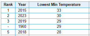
Burlington, Vermont
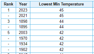
Mount Washington, New Hampshire
Caribou, Maine
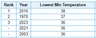
Worcester, Massachusetts
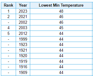
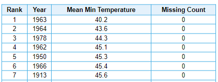
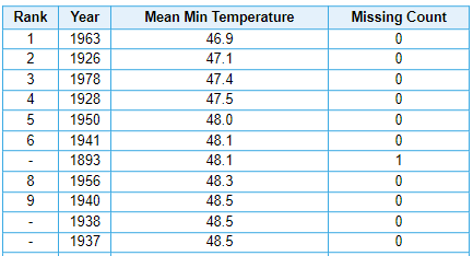
Some of these locations have observed several Septembers where the monthly mean low temperature was roughly the same as or colder than 2023's absolute coldest night. Most notably, the year of 1963 saw a mean low at Burlington, Vermont of 40.2F, or nearly 5F colder than 2023's coldest of 45F, and also a mean monthly low of 46.9F at Worcester, Massachusetts, a little more than a degree less than 2023's coldest of 48F.
Burlington, Vermont
Worcester, Massachusetts
Got down to 40 here on 9/27, 9/28. We're about eleven miles southeast of Fitchburg Municipal Airport.
-
Looks like a warm first week and then pretty close to normal afterward. Might call it "Torchtober" if the whole month looked exceedingly AN, but that doesn't seem to be the case. Perhaps "Mildtober" would be better?
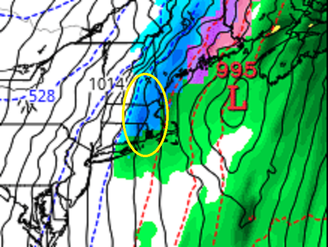
Sunday, December 17 - Monday, December 18, 2023 Storm
in New England
Posted
Rain 47F and going up.