J Paul Gordon
-
Posts
1,691 -
Joined
-
Last visited
Content Type
Profiles
Blogs
Forums
American Weather
Media Demo
Store
Gallery
Posts posted by J Paul Gordon
-
-
28 minutes ago, TheSnowman said:
Cory and CN Mountain Jackpot!

Definitely approve for Worcester.
-
Yes, but what about me?
-
2 minutes ago, raindancewx said:
Actually think Uncle Sam has the right idea here in most spots. I'd go a bit lower for NYC/NJ/Philly/Western CT. The short range models are good at detecting sleet and small warm profiles above the ground from what I can remember in college when we evaluated model performance in Nor'easters.
Would still be accumulating snow in my area (central Mass). I'd be looking in the 8-12 range for ORH considering temps, orthographic lifting. If its a fluffy snow that might not be hard to get so long as the storm is near the benchmark.
-
In an urban area, like the hilly city of Worcester, 8-12 is a major event. Not hysteric. Not minor. But a very good hit. It has to do with being in a city. If Paxton gets 8-12 it is significant but not a real big deal. I'll be delighted to see 12" of the light fluffy stuff.
-
Just now, USCAPEWEATHERAF said:
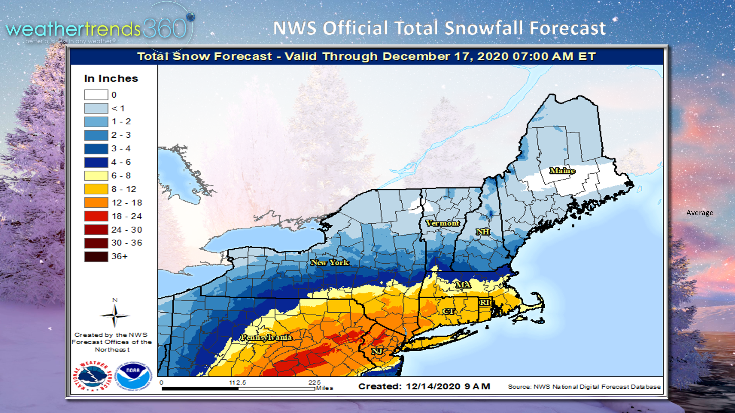
The graphics has Chatham with 10.5 inches for WED/THU already!
Really hope you get this one, James. My father in law (in Dennis) won't be so happy, though. Moved to the Cape from Worcester to leave the snow behind and has experienced some monster storms down your way over the years.
-
Will temps be low enough to have a significant effect on amounts? At this (early) point it looks like that will be the ticket for the interior.
-
Looks like a good week for coastal SNE and Mid Atlantic. I'm betting we'll cash in with at least 4" on the ground here in ORH but the cut off looks perilously close. Of course, it is a ways off. BOX has been saying stuff about cold interior temps allowing for higher ratios.
-
Any maps out for the upcoming mid week storm?
-
 1
1
-
-
Anyone going to open up a discussion of the storm that will be affecting parts of the region on Wed-Thurs?
-
1
-
-
What storm are we talking about here?
-
Looks like marginal warning in my area. Good luck to James and our NYC friends. I'll just be happy to see the ground white again.
-
25 minutes ago, Pluffmud said:
Aren’t the Kuchera maps always on the extreme side of things?
Lock it.
Still thinking a couple 3 on Monday and a 4 to 8 solution here on Wed/Thu...though it looks like NOAA has it slowing down.
-
Just now, JC-CT said:
It's a little weird to me that it basically misses Maine
Janet Mills told it to isolate for 14 days or stay the heck out.
-
1
-
 1
1
-
-
Wow 2 maybe 3 inches in Worcester on Monday. May just get a couple of 2-4, 4-8 events this week.
-
Nope. Just if we are gonna lose it someone might as well enjoy the benefits. In the next 48 hours a lot of folks will be ready to jump out windows only to see this come back some, then suppressed some, etc. The images and the discussion, though, lead one to think this is going to be a MA/NYC/Cape Cod special. Hope that James finally has a big one to celebrate. I'm fine with 2-4 of white on the ground for a few days. Last Saturday's mess is finally melting, so something fresh will be nice.
-
So, we are looking at a MA blockbuster? Good for them.
-
1
-
 1
1
-
-
Lookie! Lookie! Weather Underground is predicting 10.5" on Wednesday 12/16. I'm sold. Can only go up from here.
-
1
-
1
-
 1
1
-
-
About 6.5" of slush/snow on the deck and grass. 33F/0C. Finally sanding the street. Will be nice to have snow on the ground on a moonlit night. Looks like it will stick for a few days. Kind of weird little storm with all its permutations of rain/snow lines. Early December in SNE.
-
What's it doing in Southbridge. Had to cancel an event one year when I was stuck in Worcester with 8" of the wettest, greasiest, snow ever (absolutely beautiful though). Southbridge got only rain. People thought I was crazy to cancel.
-
0C/32F light to moderate snow, smaller flakes now. Ground covered, parts of my steep Worcester street are getting some cover. Win picking up.
-
When it looks like the pattern change is always two weeks away..... 2001-2002....2011-2012.... whatever. We're here today. That's not nothing in 2020.
Would be nice if our 2 weeks of winter encompassed Christmas and New Year, but then again, Christmas isn't about snow and getting 2020 the hell out of here counts more than any number of blizzards...
-
28 minutes ago, 40/70 Benchmark said:
There needs to be a cold source......the high is the vehicle for the cold. Worcester hills could probably pull it off, sure.
Tolland Massiff and NE/NW CT, NW RI, along 95-495 belt northeastward. Sometime interior SE MA can get a good icing in that kind situation in a generally BAH HUMBUG pattern. Have to count the little blessings in the midst of the larger storm.
-
Oh sure it can, at least where you are. We get monster slop/snow/ice storms in some scenarios under a regime like this even early in December. Maybe especially early in December. Ice storms especially. A transitory Quebec High can sometimes do wonders.
-
All it takes, though, is the right combo of cold air and precip to wind up a decent snowstorm in the interior even in lousy winters. January 2006 is a case in point of a significantly above average month (only 7 days with a high below freezing at ORH airport) with above average snow (24").
Active mid December with multiple event potential
in New England
Posted
HMIMBY?