

Vol4Life
-
Posts
238 -
Joined
-
Last visited
Content Type
Profiles
Blogs
Forums
American Weather
Media Demo
Store
Gallery
Posts posted by Vol4Life
-
-
3 minutes ago, Bigbald said:
18z Rgem looked good again. It's holding consistent.
I don’t have access to the RGEM. Do you have an accumulation map for it? Did it stay with a Miller A look?
-
1 minute ago, Mrwolf1972 said:
18z gfs don't look to bad of a run unless I'm reading it wrong. Low was in Atlanta then transfers to the coast.
I’m with you...that looked a lot closer to a Miller A.
-
 3
3
-
-
4 minutes ago, bearman said:
Just as I predicted earlier. The valley is totally surronded with wsw. LOL.
This actually makes me feel better about the Valley’s chances!
-
3
-
-
3 minutes ago, John1122 said:
The NAM precip depictions make no sense at all with any system I've ever seen. I've never seen the NW side of a storm having mix/zr/rain issues under heavy returns while areas south of there have snow. It's the most oddly structured upper level warm pockets I've ever seen.
Totally agree...I bet MRX leaves a lot of the decisions related to this forecast up to the night crew
-
1
-
-
Just now, PowellVolz said:
This doesn’t seem right at all. Way too blotchy imo.
.Love the 8”-10” blot down in South-Central Mississippi
-
2
-
-
I do not envy the NWS right now. What a tough call across the entire state!
-
3
-
-
How’d the NAM end up?
-
It will be interesting to see what the 12Z Euro shows...
-
2
-
-
3 minutes ago, fountainguy97 said:
RGEM shoves the 850 Low abt 100 miles east of other models. Because of this the Surface low never splits up into TN. Instead it shoots off to the east. This pulls the back deform band across Eastern TN instead of dryslotting. Similar to some EURO solutions recently. The problem is this robs Western areas of the deform band pivot. So while Eastern TN is better off with more qpf the western portions are much drier.
Major outlier for now.
Just when I’m about to throw in the towel, the RGEM reels me back in
-
1
-
 2
2
-
-
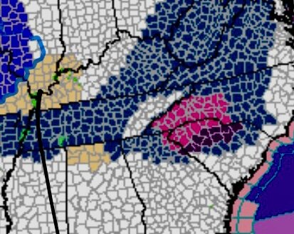
It’s really depressing to see virtually the whole state modeled for a major winter storm except the valley where it’s basically showing a heavy frost. This is more for the banter thread, but I’m hoping airing our grievances will change our luck like it did for Nashville. I remember those posters several years ago moaning all the time about the snow hole there. Now, their weather is resembling Snowshoe, WV...lol! The snow curse needs to be lifted for the Valley!
-
2
-
-
1 minute ago, John1122 said:
You can see the rain shadow up the Apps in East Tennessee, along the high Cumberlands in East KY like Black, also the areas just west of the mountains in WVA.
Down here the QPF is cut by 50% over 20 or 30 miles as the crow flies.
John, what are your thoughts on the NAM’s past couple of runs? Do you think it is plausible?
-
2 minutes ago, John1122 said:
That cut up the Apps really kills the counties that border the Smokies. The everyone west of basically those counties does somewhere between well and spectacular.
NAM is on an island right now with that track, correct?
-
1 minute ago, John1122 said:
That cut up the Apps really kills the counties that border the Smokies. The everyone west of basically those counties does somewhere between well and spectacular.
It’s the NWS jinx in full effect for the mountains. They issue a Watch and now the low is tracking directly into it.
-
Is it the track of the 850 that is causing such a discrepancy in totals for the Valley versus Middle TN?
-
1
-
-
1 minute ago, John1122 said:
The RAP loves tossing out big runs until about 8 hours before the event. We may see some 2 ft clowns from it.
Is it running right now?
-
Isn’t NAM notorious for thermal profile issues? The big takeaway for me is the Miller A look. I’d have to think that Low position and potential track would yield good results in East TN
-
4
-
-
NAM has a gulf Low. Looks more like a Miller A
-
5
-
-
The 18Z ICON is on our side too! What could possibly go wrong!?!?
-
1
-
1
-
-
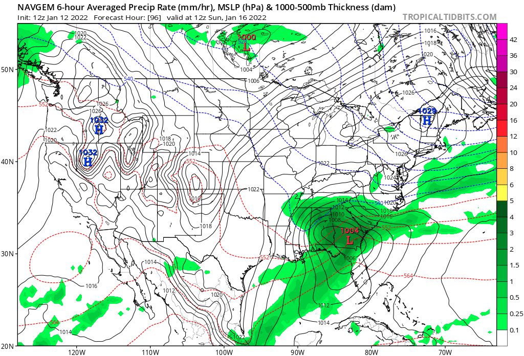
Just now, Reb said:
NAVGEM FWIW

That’s a great look.
-
1
-
-
5 minutes ago, tnweathernut said:
I am not sure I remember a year when Nashville recorded two 7+" snows. If it happened, was probably back in the 1800s. Chattanooga snow hole checks out, as do the downslope areas coming up the valley. Now if it were only 24 hours away.
Do you know what the official measurement from BNA was for the last storm?
-
This is out to 114
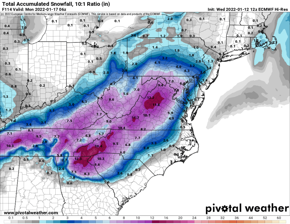
-
3
-
-
Interested to see where the Euro goes...running right now
-
1
-
-
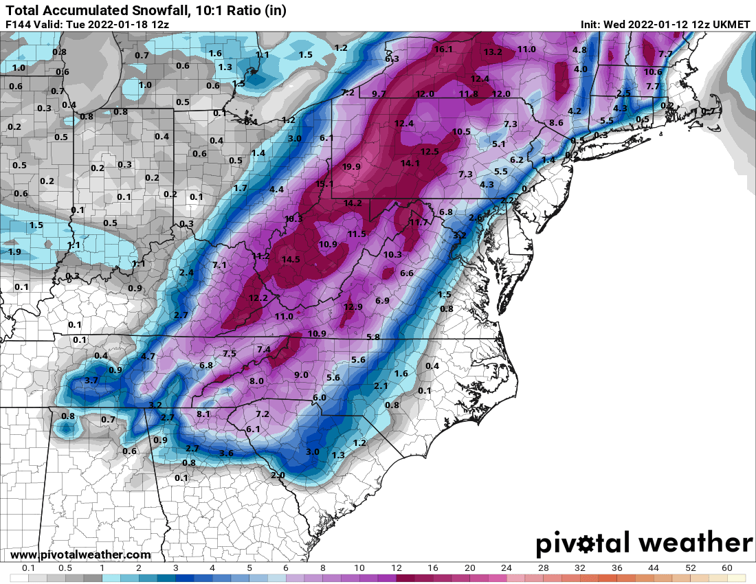
1 minute ago, PowellVolz said:
You know we are struggling when we are posting the UK. It’s pretty though
.GFS ensemble isn’t bad either...I’d take this in a heartbeat!
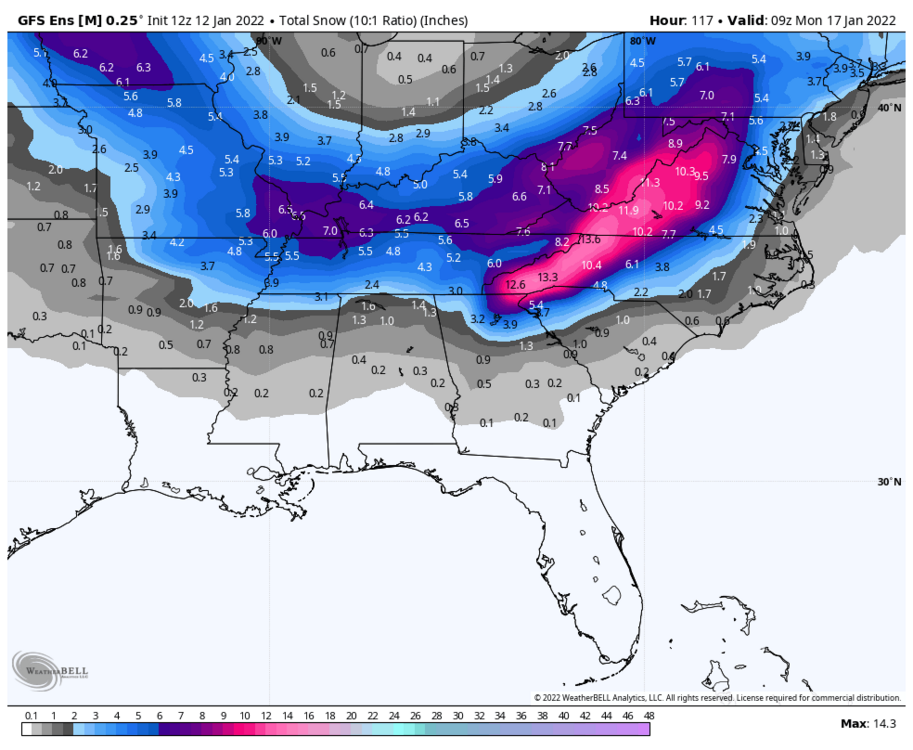
-
4
-
-
From Southeast Forum...Ukie
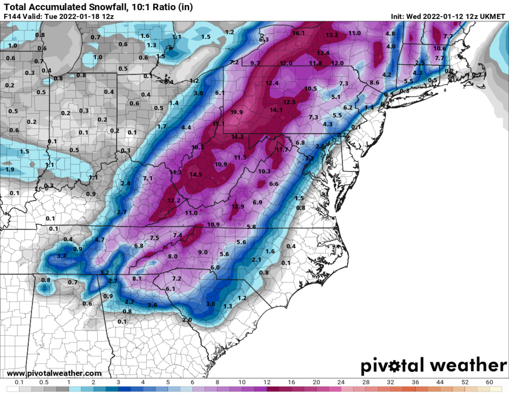
-
1
-


Jan 16-17th Boom or Bust
in Tennessee Valley
Posted
Nice...didn’t realize that!