Two Intense EF-1 Tornadoes touchdown on Cape Cod
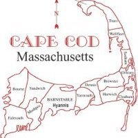
My experiences with extreme weather in the past have been hard to come by. Living on the outer Cape Cod, our chances at tornadoes and severe thunderstorms. However, the greatest chance at severe thunderstorms and including supercells occur only during the months of July and August. Now, why is this important? During the months of July and August the water temperatures in the ocean around Cape Cod, except to the southeast, have been warming substantially and are way above average for this time of the year, this is leading to temperatures over 75F surrounding Cape and Islands, which allow the soupy presence of dew point air temperatures over 70F on the Cape. This leads to some presence of instability, especially with a south wind. Early on the morning of Tuesday, July 23rd, 2019, I woke up several times in the morning around 6 am and 8 am tracking the thunderstorm complex that moved through the Cape and weakened with some light showers passing through. As the time approached 8:30 a.m. Long Island had several water spouts develop south of the area over the open ocean as velocity couplets were present with radar indicated presence of water spouts. They were moving towards the ENE at about 30-40mph. What alerted me to a rather elevated and perhaps higher chance at severe weather, at least chance of damaging winds, was the extreme presence of high wind shear values in all significant levels of the atmosphere. These levels were SFC-1km, SFC-6km, and SFC to 3km wind shear numbers. Effective Bulk Shear of 60-65 knots over the Cape stayed there all day long as the front was slow to move southeastward off the coast. Instability nosed into the area just as the cluster of storms was nearby, which turned into a meso-low influenced supercell that was moving from Falmouth, MA to Harwich, MA and Chatham, MA. The Supercell and attendant mesocyclone moved through the mid Cape region, after passing north of Martha's Vineyard with gusts over 69mph, Kalmus, MA reached a gust of 90mph as the supercell matured even more and got more intense with the velocity scans showing an intense couplet that got tighter as it reached the Yarmouth, MA region as the radar first indicated a tornado on the ground. A section of radar technology that was recently developed for tornado confirmation was the correlation coefficient. This technology can detect debris in the air other than precipitation falling. This CC radar indicated debris lofted into the air over Yarmouth, which wa likely the Cape Sands Inn roof that was lofted into the air from the touchdown of the first EF-1 tornado that peaked at 110mph over Yarmouth and Dennis, while it lifted back into the Mesocyclone. Then minutes later the tornado warning was issued for Harwich and most of the lower Outer Cape, where the second tornado touchdown around 12:10 pm or later winds gusted over 110mph in my backyard as the circulation likely passed just over the forest of trees in my backyard. There were two distinct wind bursts that occurred on my street. The first wind burst occurred at much weaker state, about 30-40mph winds, this was winds out of the southwest, than the second more intense burst was likely the rear flank downdraft or the backside of the tornado circulation that passed northwest of my house. These winds did the most damage in the area as they likely gusted over 110mph as we lost a lot of trees and some just snapped in half. Parts of Harwich Center, MA about a mile down the street, suffered complete devastation. Road closures, trees on homes, trees snapped completely in half with completely developed matured trees just snapped completely in half. Brooks Park has a large forest of large healthy trees, it looked like a plane dropped an atomic bomb was released and detonated at 20 feet high off the ground and blew up the area. Half the trees were completely snapped in half. The town center area suffered utter tree damage that no one has ever seen before here. It was chaos. The emotions were just filled with utter sadness. Fires engulfing homes, gas leaks and evacuations as homes and streets were deemed uninhabitable. We had 18 minutes of lead time, my family and I went into the basement for the first in our lives as the winds occurred over our house. Debris started flying and my family and I headed into the basement. It was the scariest moment of my life. Life is starting to get back to normal, we gained power back around 1 pm to 3 pm yesterday afternoon. Almost a day after the tornado, we thank the local emergency and power officials for a tremendous job done so far. Thanks for listening and taking the time to read my post.


0 Comments
Recommended Comments
There are no comments to display.
Create an account or sign in to comment
You need to be a member in order to leave a comment
Create an account
Sign up for a new account in our community. It's easy!
Register a new accountSign in
Already have an account? Sign in here.
Sign In Now