
Severe WX Outlook, Northeast: Wednesday, May 29th

Entry posted by Quincy ·
1,943 views
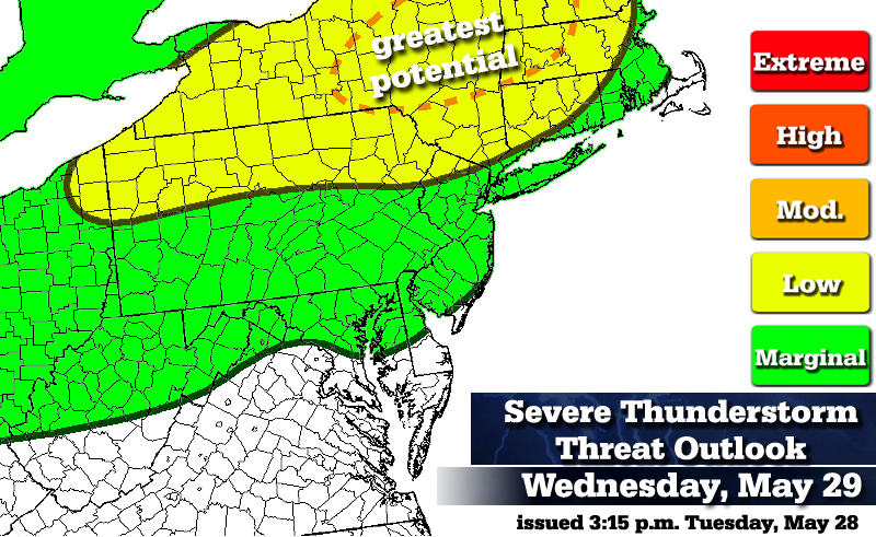 As a warm front lifts into the Northeastern United States on Wednesday, a warmer, more humid air-mass floods into the Northeast. Some thunderstorm development is forecast and some of those storms may be capable of reaching severe limits, particularly across portions of New York and west-central New England.
Low threat (Conditions are somewhat favorable for severe thunderstorms)
Interior New England, New York, northwestern New Jersey and norther Pennsylvania:
As a warm front clears, an increasingly unstable air-mass overapreads the area, along with increasing dew-points. Once lingering showers, patchy fog and drizzle clear, some daytime heating will begin to fuel the atmosphere. The severe thunderstorm threat relies on a few factors. Although daytime heating is important, it should be noted that bulk wind shear values are forecast to be low to moderate, with the strongest helicity displaced northeast into central and northern New England.
A line or broken lines of thunderstorms are expected to develop along a trough during the afternoon. The focus is on central and eastern New York, as well as western Massachusetts and southern Vermont. This area has a fair amount of overlap with respect to wind shear, instability, helicity and proximity to a shortwave passing near the Canadian-United States border. MLCAPE and lifted index values are somewhat supportive of severe thunderstorms, especially assuming there is a fair amount of sunshine to promote destabilization.
It is also in this region that both the ARW and NMM model forecast reflectivities indicate a relatively strong squall line dropping southeast between about 5 p.m. and 9 p.m. local time.
The threat appears to be mainly strong winds, but isolated hail is another possibility. Although the tornado threat is low, should wind shear coincide enough with higher helicity values, there could be a spin up or two.
This area is being monitored and may be upgraded to a moderate threat of severe thunderstorms, should model guidance trends continue.
Marginal threat (Conditions are marginally favorable for severe thunderstorms)
Elsewhere in green:
A few scattered showers and thunderstorms are possible across the region, as far south as the middle Appalachians. Across the coastal plain of New England, decaying thunderstorms could hold together as they approach Interstate 95.
Threat definitions...(Severe thunderstorm = wind gusts to 58 MPH and/or >1" hail)
Marginal: Conditions are marginally favorable for severe thunderstorms.
Low: Conditions are somewhat favorable for severe thunderstorms.
Moderate: Conditions are moderately favorable for severe thunderstorms.
High: Conditions are very favorable for severe thunderstorms.
Extreme: Conditions are extremely favorable and dangerous thunderstorms are likely.
*Disclaimer* The intent here is somewhat different than SPC severe weather outlooks. The green, yellow, etc. shadings do not directly correlate between SPC and my own outlooks. I'm still getting a feel for these outlooks, but I imagine that in more impressive severe setups, I will use red and orange colors a bit more generously than SPC might. Also, green colors on my maps indicate a marginal severe weather threat, while on SPC it corresponds to a general thunderstorm (not necessarily severe) threat.

0 Comments
Recommended Comments
There are no comments to display.
Create an account or sign in to comment
You need to be a member in order to leave a comment
Create an account
Sign up for a new account in our community. It's easy!
Register a new accountSign in
Already have an account? Sign in here.
Sign In Now