
Severe WX Outlook, Mid-Atl.: Wednesday, May 15th

Entry posted by Quincy ·
1,919 views
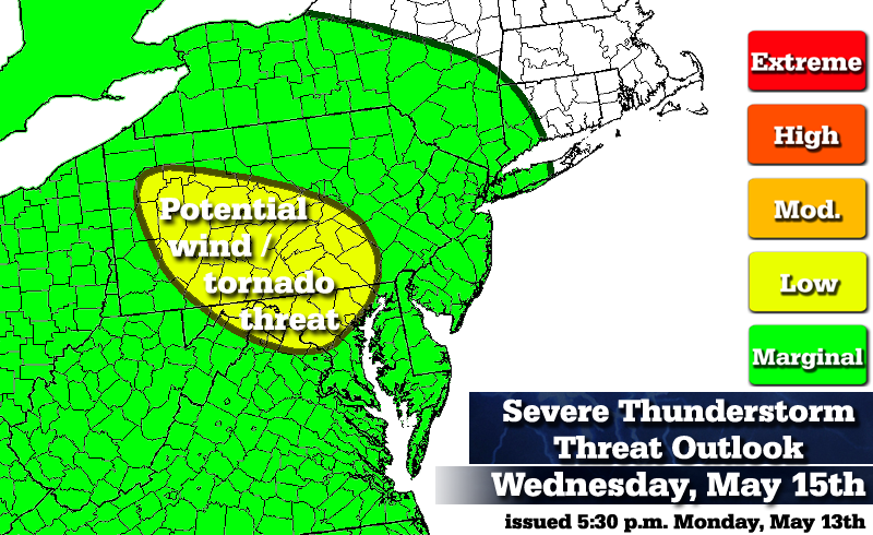 As a warm front lifts into the Northeastern United States on Wednesday, some thunderstorm development is forecast and some of those storms may be capable of reaching severe limits.
Low threat (Conditions are somewhat favorable for severe thunderstorms)
Central Pennsylvania and portions of Maryland:
A warm front is expected to lift into the Northeast on Wednesday. The focus is across the warm sector where some strong wind shear combines with surface/low-level instability to enhance the severe thunderstorm threat. The strongest wind shear and helicity values are projected to move across New York and New England, but there may be enough overlap across portions of the mid-Atlantic states to initiate some severe thunderstorms. The threats at this time look to be for damaging winds and isolated tornadoes. This is heavily dependent on timing and the ability of enough daytime heating to steepen lapse rates. The 15z SREF was showing an area of 1000-2000 J/kg MLCAPE across southern Pennsylvania during Wednesday afternoon.
Marginal threat (Conditions are marginally favorable for severe thunderstorms)
Elsewhere in green:
Although a large area is outlined in green, no organized area of severe thunderstorms is expected here. However, there is marginal atmospheric support for a few damaging wind gusts.
Threat definitions...(Severe thunderstorm = wind gusts to 58 MPH and/or >1" hail)
Marginal: Conditions are marginally favorable for severe thunderstorms.
Low: Conditions are somewhat favorable for severe thunderstorms.
Moderate: Conditions are moderately favorable for severe thunderstorms.
High: Conditions are very favorable for severe thunderstorms.
Extreme: Conditions are extremely favorable and dangerous thunderstorms are likely.
*Disclaimer* The intent here is somewhat different than SPC severe weather outlooks. The green, yellow, etc. shadings do not directly correlate between SPC and my own outlooks. I'm still getting a feel for these outlooks, but I imagine that in more impressive severe setups, I will use red and orange colors a bit more generously than SPC might. Also, green colors on my maps indicate a marginal severe weather threat, while on SPC it corresponds to a general thunderstorm (not necessarily severe) threat.
0 Comments
Recommended Comments
There are no comments to display.
Create an account or sign in to comment
You need to be a member in order to leave a comment
Create an account
Sign up for a new account in our community. It's easy!
Register a new accountSign in
Already have an account? Sign in here.
Sign In Now