
wxextreme
-
Posts
23 -
Joined
-
Last visited
Content Type
Profiles
Blogs
Forums
American Weather
Media Demo
Store
Gallery
Posts posted by wxextreme
-
-
6 minutes ago, ORH_wxman said:
My gut is the entire thing ends up north of current consensus. The upper level shortwave/vorticity is pretty far northwest. If it ends up too "straight" and loses its cyclonic curvature, then maybe I could see everything squashed into a weenie band on the south coast or near it...but my gut says north because the shortwave is strong before it enters the confluence and typically I feel like models try and decay them too quickly.
W'ell see. But I feel like someone between the pike and S NH/S VT will get the surprise weenie band with ratios.
Someone like scooter is going to get currier and ives for hours I think after the main synoptic stuff moves out. The 850-900 layer gets pretty cold so o wouldn't be surprised at good ratios during this time too. There could also be another low level qpf max down in CT/RI.
I am definitely hoping. I can definitely see some this being one of those storms that produces localized pockets of larger than consensus snow totals while others get a coating.
The comment about snow totals is what is confusing me a little with the current NWS forecast. I am thinking they are likely using the standard 10:1 ratio in their forecast to just give a general idea of the spatial representative-ness of the snow totals, but like you said, I can definitely see these being adjusted higher with new model consensus. Although if this year taught me anything, is not to get too excited. -
Joining late to this conversation, trying to get myself excited over this storm, but cant pull myself to be excited. Looking like two inches for me, enough to coat the iced concrete snow outside.
-
4 minutes ago, Whineminster said:
Nah at elevation we'll get the freezing rain, this isn't a scouring out the cold air type of event it's a cold air drain type of event.....I think.
I am not so convinced, it usually happens that the valley below usually gets CAD and the icing is more significant there. Will be interesting to see. I have been thinking of setting up a mesonet in the area to explore this
-
If the NAM is to be believed, Ashby and Central MA is going to have an interesting time with some freezing rain. I have a feeling that I may switch over to rain while the valley below will see a more freezing rain event. It is interesting the effect 200ft has on the significance of icing in Ashby.
-
2 minutes ago, HoarfrostHubb said:
Yeah...I am thinking 4-6" for my area with a bit of sleet to pack it down...Will look nice for 2 days at least
I am thinking for my neck of the woods, a good 6-8 inches with some sleet and freezing rain mixed in. Elevation will likely be key here and I am banking on the fact my WRF runs are correct. Lost the canopy of one of my trees Friday night, so a little worried with freezing rain what it will do to the rest of the tree...
-
 1
1
-
-
3 inches here in Ashby, MA. Hoping to pick up another inch with the squall line today.
-
12 minutes ago, ORH_wxman said:
HRRR finally figuring out the low wont' track NW of ORH....colder as a result.
Looking fairly good for me north of KFIT. Interesting to see how orographic enhancements set up as I live on the side of a fairly large hill adjacent to a mountain (Mt Watatic). Usually for these types of storms it aids in snow totals.
-
13 minutes ago, Ginx snewx said:
Pretty sure Wiz didn’t wish cast and pretty sure no one said they expect those winds. You guys have a way of making mockery out of a basic question.
Oops, didnt mean to call anyone out, but trying to understand how it was even brought up. Sorry about that
-
1 minute ago, dendrite said:
You have to go up to like 700mb to even find 60kt.
Like I said, grasping at straws here trying to figure out how this was even brought up. I see a 50kt at 900mb, but that is about it.
-
Just now, weathafella said:
I don’t think my house ever had that. I live in a wind hole.
I have had a 70mph wind gust at my house in Ashby, MA. This was due to a very strong gust front. I also live in a wind tunnel and have three RM Young anemometers and a Downeaster Anemometer set up at my house (well sited) and get 40-50mph winds, but 60+ has only happened once in 3 years.
-
6 minutes ago, dendrite said:
Where are the winds anyway?
There might be a slight arguement for Central to Eastern MA looking at these plots. Grasping at straws here trying to figure out the wishcast.
-
Just now, dendrite said:
Where are the winds anyway?
Very, very true, I was looking at a similar wind field, and was extremely confused as to where this was even coming from. I honestly thought I was missing something.
-
29 minutes ago, dendrite said:
You guys honestly think we're going to mix down 60-70kt with CAA?????
Big difference between reality and a wishcast. I agree with you, there is no way we will be able to mix down 60-70kt winds.
-
On 1/18/2019 at 7:21 PM, OceanStWx said:
I want to say something snarky, but we do. So does BOX. Since we started probabilistic snow we’ve documented this.
My SOO’s gut check is: is there is any real chance that your forecast is too low? If you say no, then you have a high bias.
OceanStWX, No offense wasnt meant by it (and I believe by reading none was taken). I have had the opportunity to visit your WFO while studying meteorology at Plymouth State University. Great facility and great forecasters there. One of my old coworkers lived in New Ipswich, NH and I lived in Ashby, MA. We were basically neighbors (1 mile down the road) and we would always go back and forth on how BOX anf GYX both predicted their snow totals.
I also agree, BOX does tend to over predict at times as well (as I am sure all WFOs tend to do at one point or another). It was just amusing to see that southern NH tends (especially in my neck of the woods) gets over predicted quite a bit. I do agree with your gut check though, and it is something I tend to do as well. -
Just now, sbos_wx said:
HRRR is useless at this range
If I went back to the beginning of this forum, I would believe we all would be looking at the Global models 5 days out, which I would argue is also equally as useless, but definitely worth the conversation.
-
1
-
-
I have been watching the 18Z HRRR run, from first glance, it seems to be keeping temps slightly cooler than the previous GFS and NAM run (atleast up to 6Z). Will be watching the HRRR runs extremely close now!
-
5 minutes ago, Baroclinic Zone said:
Stop. Collaborate and listen. Ice is on a brand new mission.
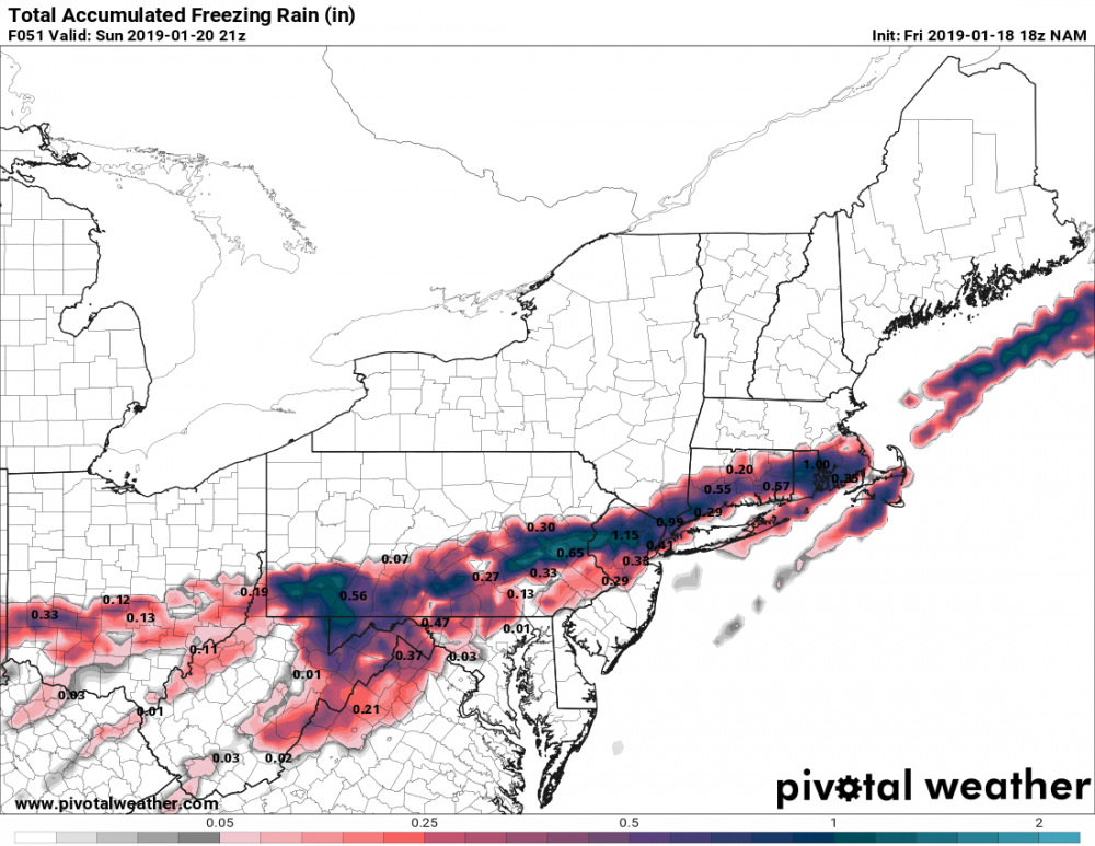
I would be apt to say these numbers are inflated due to inherit issues within the modeling dynamics. For one, the icing is (from my understanding) interpolated over time period and does not capture what happens during intermediate time steps.
Not to mention, the upper air temperatures aloft have been in question as to how much warm air will be overrunning. Because the thermal soundings are in question, the ice accumulation rate forecasts will be questionable at best. I would expect these numbers to fall as modeling time intervals become more refined. -
18Z NAM is bringing more sleet over Northern MA, which is interesting. I'd be more apt to say with this profile that it would likely be switching back and forth. There will be some fine details needed to be worked out before I start making definitive yes all snow or mixing in my neck of the woods (north of Fitchburg, MA).

-
1
-
-
2 minutes ago, wxextreme said:
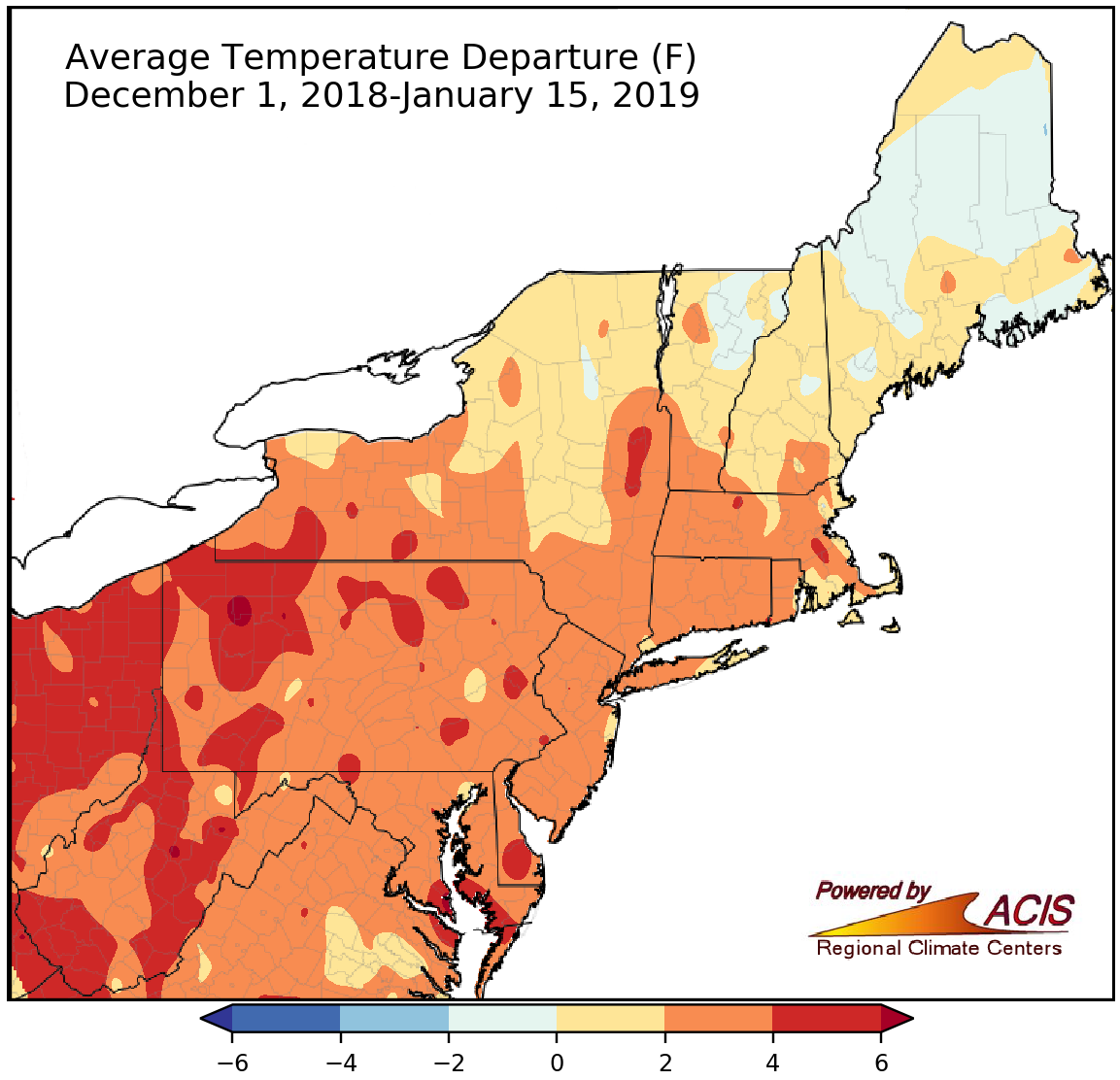
The Northeast Regional Climate Center released this graphic earlier this month showing the Dec 1 - Jan 15 departures from normal showing a slight deviation from normal temperatures.
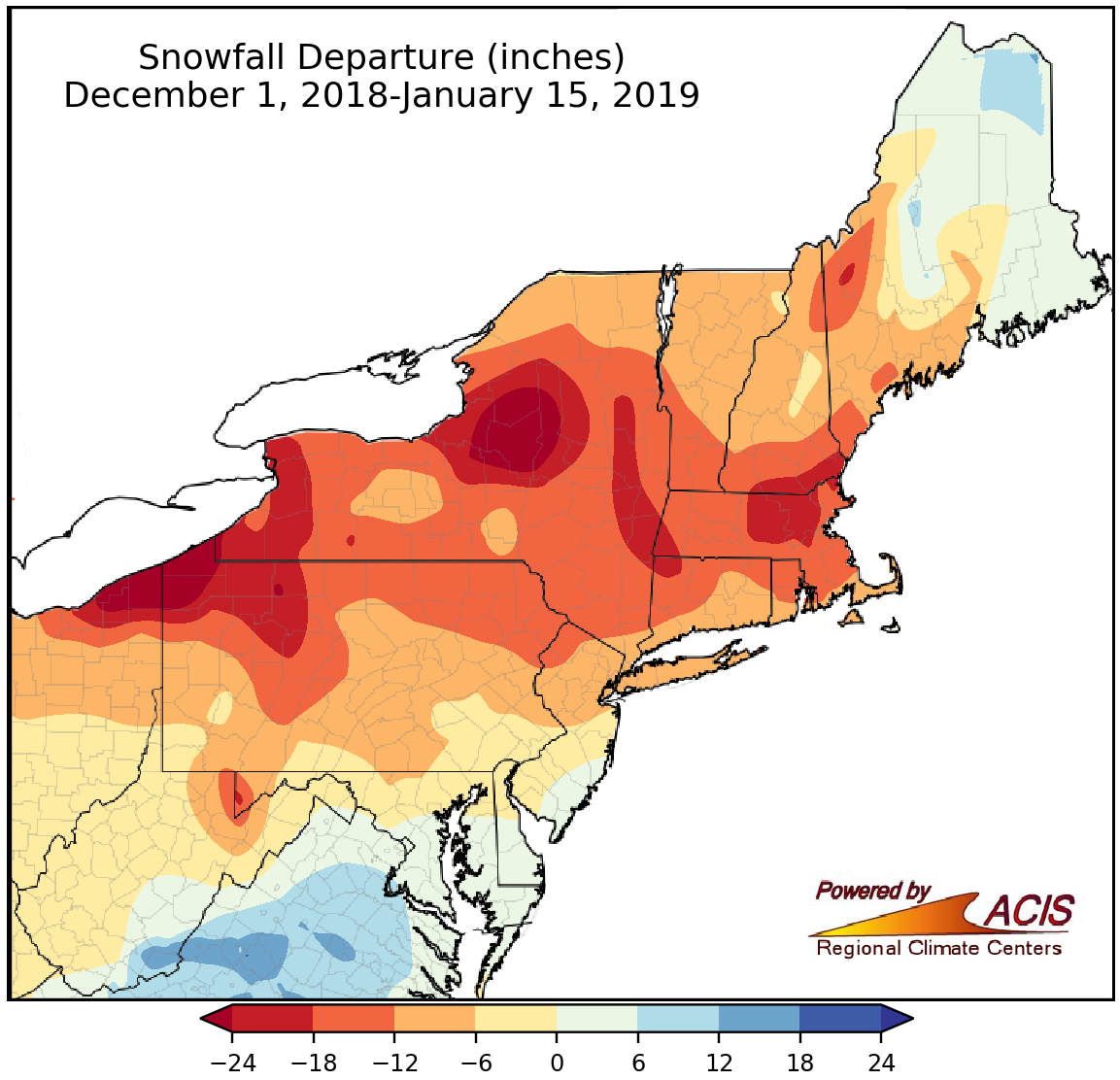
With this, here is the departures from normal snow totals:
-
6 minutes ago, ORH_wxman said:
It's warmer than normal so far, but not by a lot. ORH was +1.6 in December and is +1.7 so far in January (and that will fall considerably, below normal month is very likely)
You are correct, the unfortunate chaos in the pattern has cost us the snow much more than temps.
The Northeast Regional Climate Center released this graphic earlier this month showing the Dec 1 - Jan 15 departures from normal showing a slight deviation from normal temperatures.
-
1
-
-
3 minutes ago, WxBlue said:
Even staying all-snow here, I'm having a tough time seeing us matching 16-18" forecast from GYX. I'm comfortable with my 12-18" call for my town.
GYX tends to over predict, especially in Southern NH. I live in Northern MA and the general discrepancy between BOX and GYX (even though I am walking distance from the NH boarder) can be about 2-4 inches. I'd say you would be safe with your call, but probably toward the lower end.
-
Just now, ORH_wxman said:
People are still suckers for the models despite one of their biggest weaknesses being handling strong CAD with an arctic airmass in place. Doesn't seem to matter how many times the discussion happens, there's always posts that defer to the authority of the model output.
MOS/ Model Munchers is the term we used in college to describe these people


NE snow event March 4th
in New England
Posted
Just figured I would contribute here and post this image I found awhile back about forecasting n-hours out. This holds very true for this year and seemed appropriate for this thread.