

pbrown85
-
Posts
38 -
Joined
-
Last visited
Content Type
Profiles
Blogs
Forums
American Weather
Media Demo
Store
Gallery
Posts posted by pbrown85
-
-
4 minutes ago, burrel2 said:
21z RAP just came out and it's all snow for the northern upstate,(assuming low levels aren't as warm as depicted.)
In fact, it's not even isothermal at my house. I've got a -1C buffer through the column.
Let's hope that comes true! Coming from a teacher in Pickens County hoping for an early release tomorrow!
-
 1
1
-
-
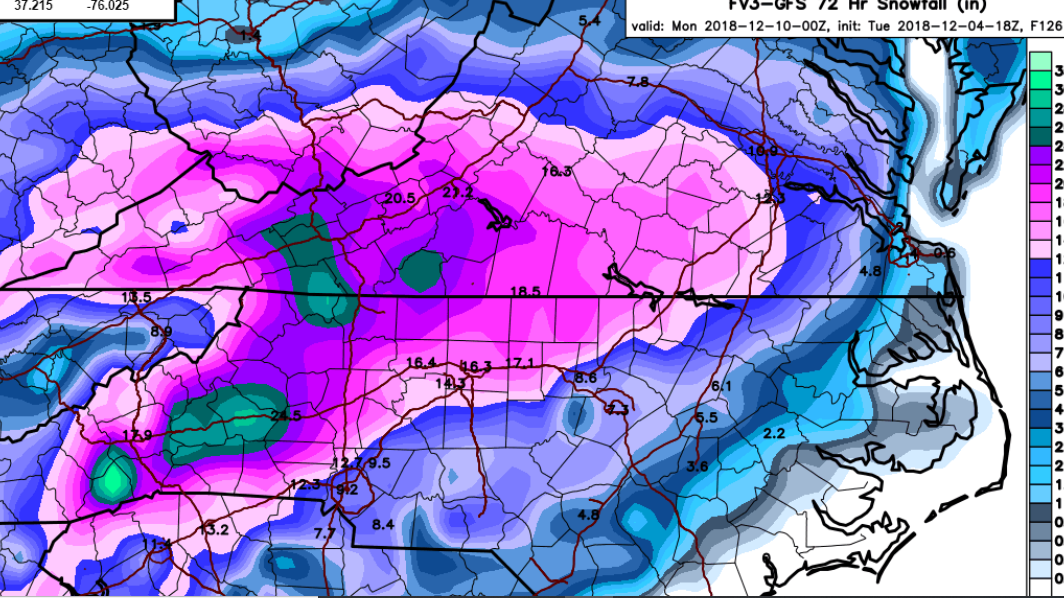
2 minutes ago, wake4est said:
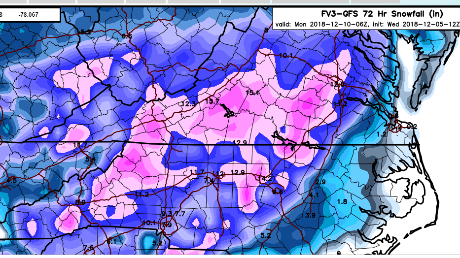
fv3 Kuchera Map through 60

That FV3 Kuchera map has been crazy consistent in showing a good snowfall for GSP. I wonder what it is seeing that others aren't?
-
11 minutes ago, ozmaea said:
Do u thk hes crazy
Sent from my SM-N950U using Tapatalk
He could be on to something or he could be just generating a little hype on his fb page. He's not a Met around here anymore so he doesn't really have any real negative consequences if he is wrong, but on the off chance hes right people will think he is a winter weather genius.
-
1
-
-
2 minutes ago, UpstateSCGamecock said:
Andy Wood Former Met Fox Carolina


.He must really be thinking that the cold is going to dive way down. I hope hes right!
-
5 minutes ago, lilj4425 said:
Sleeting here in Greenville already.
For people with more knowledge, will earlier onset of precip help keep temps down and help build in that CAD?
-
1 minute ago, burgertime said:
If NAM verifies this would be a once in a lifetime storm whether it be ice or snow. There is a TON of QPF with this.
If I'm not mistaken the NAM is pretty close to what the GFS FV3 has been showing for a few days now correct?
-
Just now, mackerel_sky said:
I’m hugging the NAM and GFSv3! And taking my 2” of sleet!
If you get 2" of sleet in Simpsonville I'll be happy with my 4" of snow in Easley!
-
 1
1
-
 1
1
-
-
Just now, DopplerWx said:
hr32 and upstate looks to be all snow.
Really looking like it's going to be the "north of 85" special for the upstate. The south trends are encouraging. Hopefully that wedge can get the cold air a little further south to get more upstate SC people in the game!
-
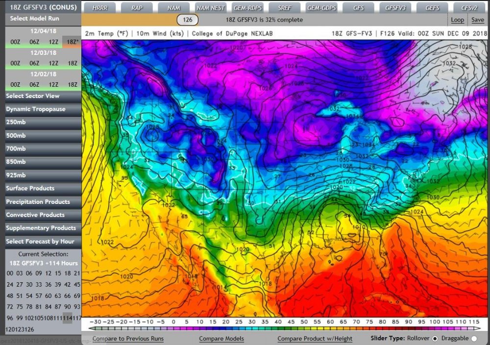
Does anyone have any theories as to why the GFS FV3 gives so much more with it's winter output than the other models so far?
-
10 minutes ago, mackerel_sky said:
Our local met , CJ , kept harping on 85 and N getting all the snow, while the modeled sim radar behind him, had snow line down to greenwood, for like 8 hours! SMDH
I wonder if he's being a bit more conservative since he's been burned by over hyping a storm before.
-
1 minute ago, Poimen said:
FV 3 Kuchera...not as robust as the GFS but still a good storm (thank you, captain obvious!)
Still trying to learn but Kuchera is just snow measurement? That takes out other p-types correct?
-
Just now, Iceagewhereartthou said:
Feb 2014. Local Mets calling for 8-12, with one or two going 8-14. Euro showing 14-18 at go time. Warm nose. Sleetfest. ZR. 3 inches max!
Yup that's the one!
-
2 minutes ago, Northern Foothills Snowman said:
Isn’t the FV3 the new model that took the place of the GFS?
It will take the place of the gfs in Jan
-
1 minute ago, SENC said:
Is It ok to use this? for Useful analysis? (Is this page allowed)..?? My sincere Apologies if it isn't..
Man look at that wedge!
-
1
-
-
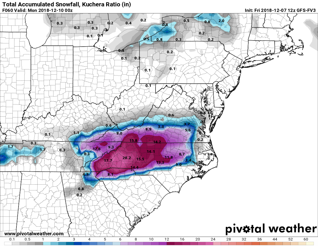
5 minutes ago, Poimen said:
FV 3 Kuchera through 0Z Mon.

Living in the Greenville SC area I also remember maybe 3 years ago we were super close to a modeled huge storm. Gsp even mentioned 12" possible for Greenville. We ended up with maybe an inch of slush after all the cold rain and mixing. Crossing my fingers that this one gives us something decent!
-
3
-
-
If that verified people would be talking about it for years!
-
So please correct me if I'm wrong. For me in the Upstate of SC it seems like the FV3, Ukie, and Euro are all pretty close with totals for my area with the GFS seeming to move a little southwest with it's totals. Good trends?
-
I will take the Euro and be happy for the rest of the winter!
-
1
-
-
Why is the FV3 showing so much more snow for Upstate SC? Is it seeing something in the CAD that other models aren't seeing or is it just that far off?
-
So I have seen people talk about the NAM at this range not being accurate, then some people saying that it does a great job with the temp profiles in these situations? Is the NAM to be believed with it showing the cold getting down to upstate SC or are people just hugging the NAM because it shows the temps we need?
-
1 minute ago, Cold Rain said:
Its snow maps have an established track record of sucking. But it's skill seems better than the regular GFS, overall. Honestly, there are too many factors for any model to have a lot of skill at this lead. Best course at this point is to look at the range of possibilities, compare to analogs, and blend in climo. A good winter storm is possible, but we need to observe trends over the next 3 days or so before we can legitimately hone in on who gets what.
Thanks! Still trying to learn some of the nuances of model watching. Following this forum has been a big help!
-
2
-
-
19 minutes ago, Queencitywx said:
I'm really interested in how the FV3 does this event because it's been routing the actual GFS for some time now.
Is this the first big winter threat that the FV3 has done for this area? Or does it have an established track record?
-
4 minutes ago, lilj4425 said:
Don’t worry. The warm nose will ruin it all. Either that or a lot less qpf then what is projected by the models. Always something.
CJ with wyff is slowly starting his hype train on his fb page. That's the biggest jinx we could get!
-
16 minutes ago, NC_hailstorm said:
I might save this one.Day 8 Euro.
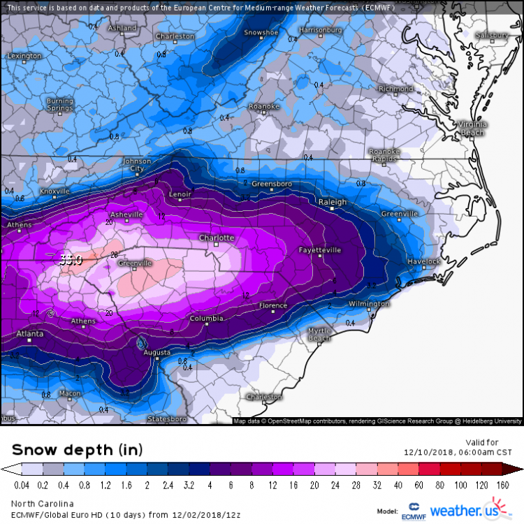
Umm give me 1/3 of the 30+ total IMBY and it will still be a storm I tell my grandkids about!
-
1
-


One More Shot: Feb 20-21 Event
in Southeastern States
Posted
How accurate is this model with thermals? Looks like temp will be our biggest issue in the upstate.