

kperk014
-
Posts
66 -
Joined
-
Last visited
Content Type
Profiles
Blogs
Forums
American Weather
Media Demo
Store
Gallery
Posts posted by kperk014
-
-
12 hours ago, shaggy said:
This guy basically drove right into the back of the circulation. Later in the video you can see the massive size of this tornado.
That was very 4/27/2011 ish.
-
17 hours ago, Windspeed said:
This is the best footage so far of the Lee County wedge as it crossed US 280 near Smiths Station. The autofocus missed but you can clearly see the violent upward motion at the beginning.
DANG! That sucker was hauling ass!
-
Since it was pretty much ignored in this thread, I'll just throw these in:
https://www.facebook.com/watch/?v=322535525044082
At almost 100 years old, Wilson is still hanging in there!
-
 1
1
-
 3
3
-
-
From WHNT in Huntsville:
Strong to severe storms approach early Saturday, continue through Saturday evening
Morning temperatures dropped into the mid-to-upper 50s Friday morning, but with the strong southwesterly wind, we are seeing those temperatures rebound back into the upper 70s to low 80s Friday afternoon.
These strong southwesterly winds are setting the stage for active severe storms west of us today; while we are in the low-80s with a south breeze, strong storms develop over Oklahoma, Texas, Arkansas and Louisiana this afternoon and evening. All of that shifts into Alabama and Tennessee on Saturday. We expect a lot of rain, gusty winds, and a risk of a few severe storms during the day Saturday and into Saturday night across Alabama and Middle Tennessee.
Saturday’s stormy setup: Saturday’s stormy weather is getting clearer, but questions remain about timing and intensity.
The Storm Prediction Center outlines a large area where severe storms are possible Saturday from the Gulf Coast north to southern Kentucky, the *ENHANCED* risk area is now further north to include parts of north Alabama south along the gulf coast; that’s where storms will likely be (1) strongest and (2) most widespread.
Those southern storms may also interfere with the storms in North Alabama and Tennessee. A large complex of storms that develops near the coast often reduces or eliminates the stormy weather in the Tennessee Valley. That’s one scenario that the entire forecast hinges on for Saturday afternoon and evening: big southern storms, little if any severe weather in North Alabama – no southern storms, greater risk around here.

What to expect Saturday: Showers and storms move into Northwest Alabama between 7 AM and 12 PM, then they spread east through Huntsville to Northeast Alabama by late morning through early afternoon. A few of these could be severe: especially in Lauderdale, Colbert, Franklin, Lawrence, and Limestone Counties before 9 AM.
The line weakens as it moves east of Huntsville into a more stable environment, but rain is still likely as showers develop on and off throughout the morning and early afternoon.
The greater severe weather threat comes in the afternoon and evening (into Saturday night) as we carefully watch what’s happening south of us. This slow-moving storm system leaves a strong southwesterly flow aloft (10,000 to 20,000 feet above our heads), and that likely brings more rain and storms in from the south Saturday evening. If the Gulf Coast storms are strong enough, it will just be rain in North Alabama. If the Gulf Coast storms don’t materialize, we could see some severe storms between 5 PM and midnight. The pieces are in place for severe weather, but those southern storms are a huge factor in whether they will actually develop in North Alabama.
-
1
-
-
SPC AC 131731

   Day 2 Convective Outlook
   NWS Storm Prediction Center Norman OK
   1231 PM CDT Fri Apr 13 2018

   Valid 141200Z - 151200Z

   ...THERE IS AN ENHANCED RISK OF SEVERE THUNDERSTORMS ACROSS PORTIONS
   OF THE CENTRAL GULF COAST STATES...

   ...THERE IS A SLIGHT RISK OF SEVERE THUNDERSTORMS SURROUNDING THE
   ENHANCED RISK FROM THE NORTHERN GULF COAST TO TN...

   ...THERE IS A SLIGHT RISK OF SEVERE THUNDERSTORMS ACROSS PORTIONS OF
   SOUTHERN IL AND IN...

   ...THERE IS A MARGINAL RISK OF SEVERE THUNDERSTORMS FROM THE LOWER
   MISSISSIPPI VALLEY TO PART OF THE SOUTHEAST STATES AND NORTH TO THE
   LOWER OH VALLEY...

   ...SUMMARY...
   Strong to severe storms are expected across the lower Mississippi
   Valley and central Gulf Coast States with a threat for damaging
   winds and a few tornadoes, some possibly strong.  Isolated severe
   storms will be possible in the Midwest Saturday afternoon to early
   evening.
http://www.spc.noaa.gov/products/outlook/day2otlk_1730_prt.html
-
-
-
Central Alabama 5 years later
http://abc3340.com/news/videos/april-27-2011-cordova-community-continues-to-recover-from-ef4-tornado
http://abc3340.com/news/videos/april-27-2011-hackleburg-nearly-wiped-off-the-map-by-ef5-tornado
http://abc3340.com/news/local/abc-3340-special-report-april-27-2011-five-years-later
https://weather.com/storms/severe/news/2011-tornado-superoutbreak-james-spann-marathon-broadcast
-
One gentleman described the Phil Campbell tornado as a "giant octopus" as it came over the mountain into Mount Hope. He's not in this video.
-
Interesting view of the Union Grove, Al tornado of April 27, 2011.
-
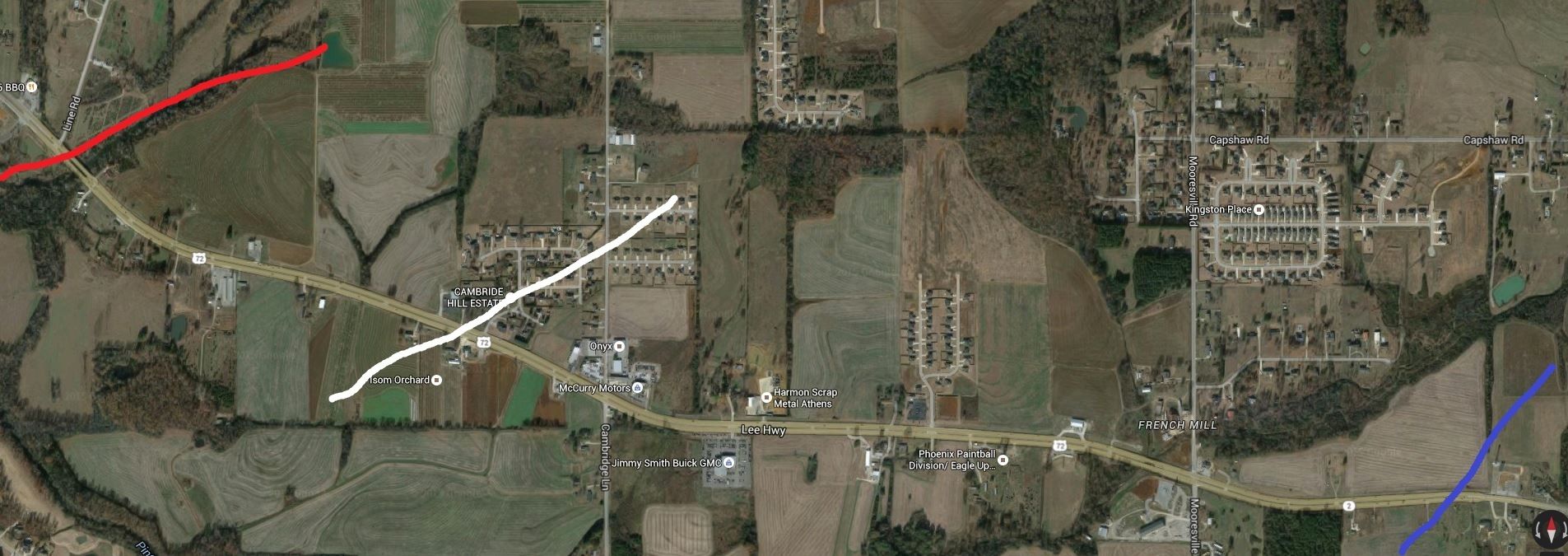
Approximate paths:
Red - Tanner 2
White- Tanner 1
Blue - Tanner 3 (2011)
-
Holy hell, it's amazing how many people that day who were shooting video, were oblivious to how close they almost came to getting swept off the face of this earth.
This is a fairly unseen video (about 1,800 views) that reminds no matter how awe-inspiring a tornado can be, there's something terrible going on under it. Check out the exchange at about 3 minutes when the tornado sprouts it's multiple vortices. There is cheering until someone reminds them that people are dying with a little profanity.

Why was late April in the SE forum archived?
in Southeastern States
Posted
There was nothing of importance in this version of the late April SE forum. Just some folks talking about the temp or their garden. There was no mention that over 300 people might be killed the next day. I don't remember the thread being THAT empty. I remember really good conversations by several people. None of that is there.