

SlowerLowerDE
-
Posts
143 -
Joined
-
Last visited
Content Type
Profiles
Blogs
Forums
American Weather
Media Demo
Store
Gallery
Posts posted by SlowerLowerDE
-
-
Oh Lord, we have another tornado coming in this direction! This is getting real old.
-
 1
1
-
-
45 minutes ago, CAPE said:
Its always something lol. It seems to go down a lot. It was a hard drive failure of all things the other day.
It’s back up for now.......
-
1
-
-
1 hour ago, CAPE said:
FFS just replace the whole damn system..
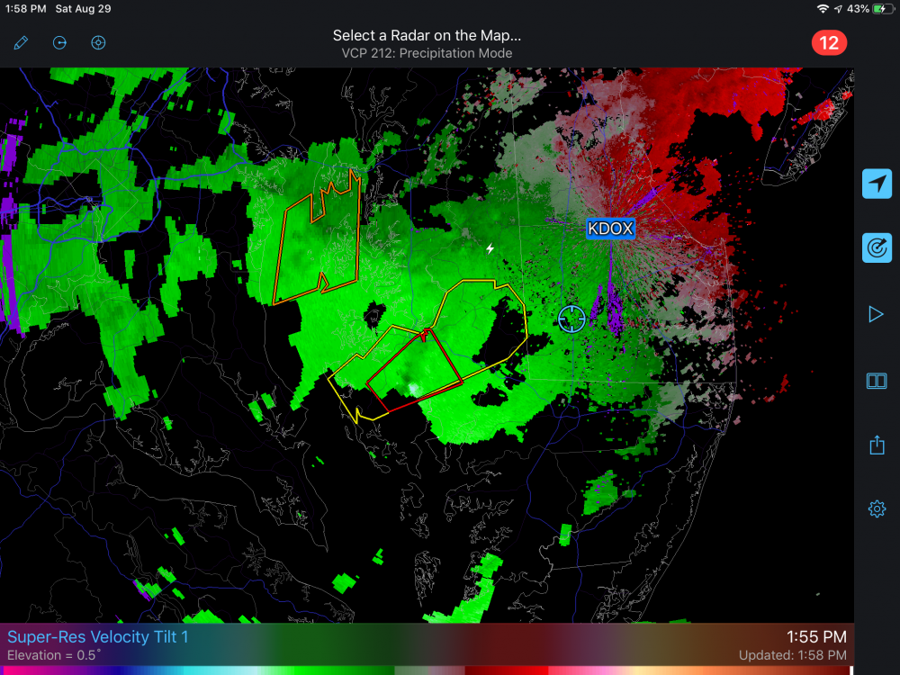
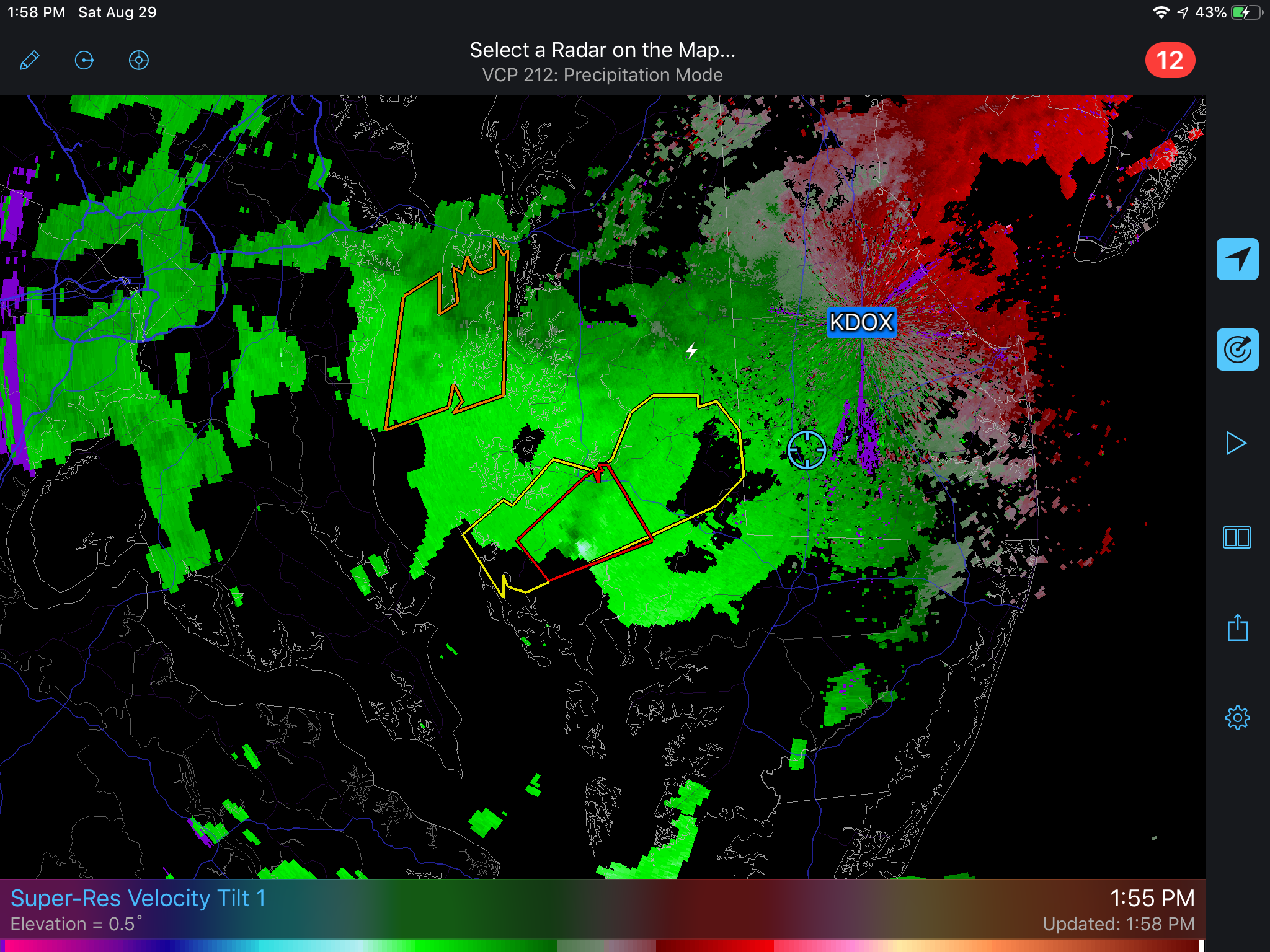
DOX RADAR IS INOPERATIVE. TECHNICIANS HAVE BEEN NOTIFIED. RETURN TO SERVICE IS UNKNOWN AT THIS TIME.
It was down on Saturday then back up yesterday. I am sure this is not a new issue. Bad timing for sure.
-
C.A.P.E.
On radar south Dover looked like it got a pretty good hit from a tornado. I could not tell if it was the same cell that came by your or not. It was a separate warning.
-
2
-
-
21 minutes ago, WxWatcher007 said:
Big wind in DE
Yes, that is easy to believe. One gust in particular bowed a huge Maple tree over. The tree survived but wow!
-
2
-
-
From Mt. Holly:
NEAR TERM /UNTIL 6 PM THIS EVENING/...
Its been an interesting couple of hours this morning as the warm
frontal rainfall generally fell east of where we had anticipated
it. We`ve seen generally 0.5-1" of rainfall east of the I-95
corridor and across DelMarVa. Based on forecast RFC Flash Flood
Guidance, and DOT reports have confirmed, this has been causing
the potential for some ponding of water over roads and areas of
poor drainage. The pressing issue is that right behind the
rainfall fall we`ve seen significant increases in reports of
stronger winds. Looking at one hour pressure changes in the HRRR
and from obs in the area we`ve seen all the signatures of a
gravity wave propagating through the Mid-Atlantic. We`ve issued
an SPS to highlight this threat.

Moving forward into today, SPC has expanded the SLGT just a bit
further north and we think that today`s set up to be an impact
day with regards to convection. The timing of the threat should
run from around noon through 8pm on the late side. Based on
our mesoanalysis forecasters thoughts, we should see initially
discrete cells moving through before coalescing into a line of
storms. All of the typical steering flow indicators, deep layer
shear, bunkers-right, and storm relative flow all is oblique to
the boundary. This should mean that as the storms approach the
I-95 corridor we`ll be looking at a QLCS event with the
potential for rotation along the line.
-
You can make your own yeast starters from raisins or honey. See YouTube on this. It is easy and takes about 24 to 48 hours.
-
21 for the low here. It is back up to 26 already. We had a heavy dusting of snow. It has melted except for raised surfaces. I forgot and left my CoCoRaHS gage out over night. It is frozen and frozen into the bracket. It has .46 of ice in it. Will try to recover it around noon and get the true reading.
-
2
-
-
Where is Lucy with the football?
-
I have to add that the storm with the tornado in April was worse in thunder, lightening and wind when the tornado passed by. This evenings storm had a lot more rain and lots of hail. It has been an amazing year for severe in this area.
-
Oh my what a storm we had this evening. Winds to around 60 mph. Two rounds of hail with the first round bringing 15 minutes of quarter size hail. The second round was briefer and the hail was smaller. I lost my persimmon tree which was loaded with green fruit. We had 3.63 inches of rain in less than 45 minuets. Every bit of it quickly sunk into the parched ground. I made a spotter report by phone and the power went out in the middle of the call and the phone disconnected. The NWS employee could hear the hail hitting the windows during the call. They said the storm had a large hail core. I was able to call back and finish the report. Whew.....my tomatoes and peppers took a beating too. This was the worst TS in many years for this area.
-
2
-
-
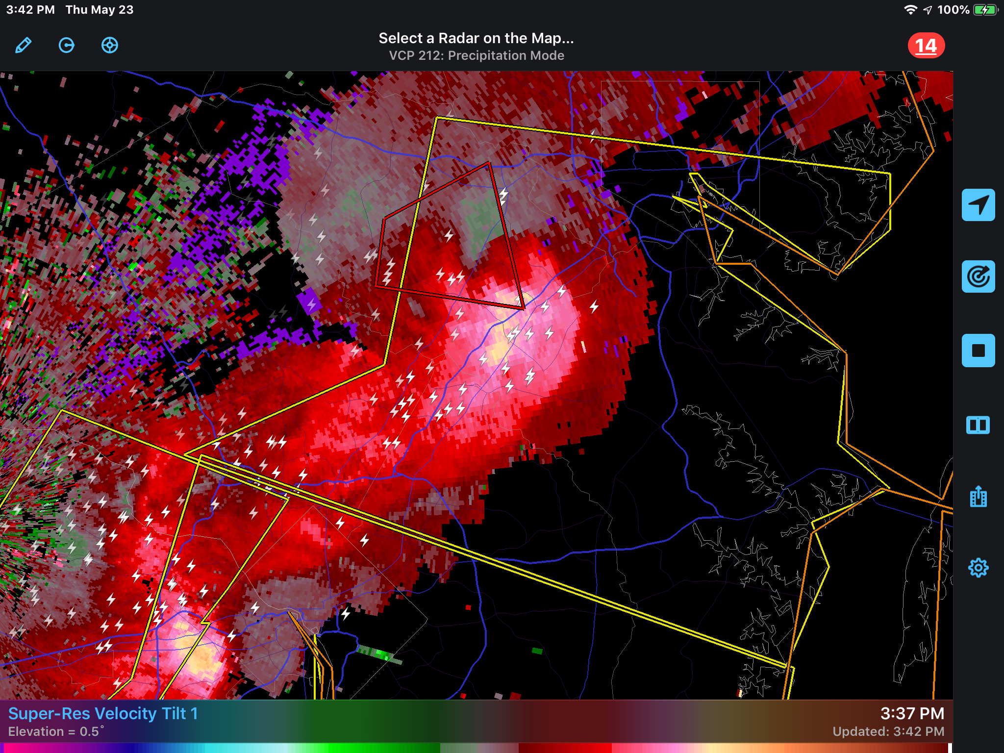
Here is a shot of the tornado warned area from Radar Scope

-
2 hours ago, Stormpc said:
My house is on the sound straight across between Carova and Corolla. Tuesday was move-in day to our house and we were outside all day. I have a view clear across from my house of the sound and didn't see it. Storms dance around us all day. We got a brief shower later in the day but that was it. Good picture.
The sighting was at 8:20 am. I just love the sound. We had a great time. You are fortunate!
-
Just got back yesterday from Corolla Light N.C. We spotted this from the rental house overlooking Currituck Sound on Tuesday morning. It was rotating and seemed to be reaching the water but soon dissipated. There were no watches or warnings out. I reported it to the NWS since I became a spotter at the Georgetown DE training held there by the NWS on May 4. It has been a busy time for me with severe this year with the EF2 that went by my place near Laurel by about 3 blocks. THAT was scary.

-
5
-
-
I have to say that the NWS report for the Laurel area reads like the damage is much milder than what we are seeing. There were more than “several” homes and barns damaged.
-
2
-
-
RT 13 North bound is open now. South bound is one lane south of Laurel Village. There are still a lot of power outages. 1.28” rain here. It’s a beautiful day weathewise.
-
1
-
-
Power is back on. No damage here. News is not good. Sussex County First Alert (Facebook) says that there is a lot of damage in this area and advises us to stay home. A number of roads are closed including RT 13 and Alt. 13. Schools are on a 2 hour delay. That is all I have from here. Am not going out to add to the confusion.
-
2
-
-
That was really scary. The lightening and wind were really bad. I wish we had better news coverage here. Del Elec Coop outage map shows lots of power outages mostly in the western parts of Kent and Sussex counties. Our power is still out and will likely remain that way for awhile. I hope no one was hurt.
-
1
-
-
That is extremely close to me now. Power is out. Heavy thunderstorm with continuous lightening.
-
1
-
-
Jan 12-13. 5"
Feb 1. 2.5"
-
56.97"
-
12-9 1.25
-
We have over an inch of snow here near Laurel. Now it is sleeting. This thing may over perform what the forecast is.
-
1
-
-
15 minutes ago, Squatchito said:
This. I'm right in between Wilmington and Carolina Beach. Fairly terrified at this point. I bought a bunch of stuff yesterday in preparation, but I'm fairly sure it was a waste as I think it's looking a better and better idea to simply run.
I'm supposed to go out of town on Wednesday for some training... to Roanoke, VA. This storm is stalking me.
I hate posters like that. They seem to be gloating on the misfortune of others. You can't stand and ride this out. Evacuating is the only way to go if this continues the current path. If so the training in Roanoke will probably be canceled or they won't expect you to be there under the circumstance. Don't wait until I 95 or other routes become parking lots. Keep in touch with your loved ones and I will pray for you.
-
2
-

2020 Mid-Atlantic Severe Weather - General Thread
in Mid Atlantic
Posted
It looks to have lifted. The warning is canceled. Thank God.