

LawdogGRNJ
-
Posts
63 -
Joined
-
Last visited
Content Type
Profiles
Blogs
Forums
American Weather
Media Demo
Store
Gallery
Posts posted by LawdogGRNJ
-
-
Clear roads just west of EWR. 1/4 to 1/2 on the grass...not much falling.
-
Curious, why is the amount of wind shear that Milton has to go through to get to FL not forecast to weaken it dramatically?
-
Did Ernesto just split into 2 storms?
-
 2
2
-
-
7 hours ago, Ed, snow and hurricane fan said:
40 to 50W? or 60-70W?
40 tp 50W is eye catching, there is a very narrow slot of lower shear in a trough. It would need more than a few days with improving conditions. I think it stays a frontal trough myself. Over 30C water would help, fronts either side of Florida could do that. Even a front more than a ways E of the Bahamas can do it. That one, not so much.
About 35N, 70W now. Off the NC coastline.
-
Is there another system trying to form north east of Invest 92L? Low shear area. Shows on water vapor and clouds are just starting to pop.
-
No big surprise this storm is not getting farther north.
Take a look a the monster Tuesday's snow became. Impressive.
-
1 hour ago, wishcast_hater said:
You must be one of the most negative posters on here. Always bringing up worst case for it not to snow, always looking forward to “torches”. It’s tiring.
.Given your username, I'd expect you to be his greatest champion...lol
-
2 hours ago, STILL N OF PIKE said:
958 mb . Just copied your post bc so many more see it when the tweet is embedded
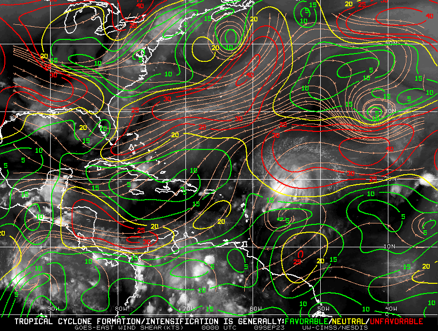
Good image of the shear map and it's affect on Lee. I'd expect reorganization and intensification after moves into more favorable conditions to the west.
-
On a (slim) positive note, Ian will wipe the FL drought map clean....
https://droughtmonitor.unl.edu/CurrentMap/StateDroughtMonitor.aspx?FL
-
Meant to share this yesterday. This is a hyperlapse (10 seconds of video compressed into 1) I took yesterday of the "weak rotation" spotted in the cell that passed through Bloomfield NJ at 12:38 PM DST.
This is looking south just as damaging winds (possible RFD?) hit my area. Thankfully, it dissipated quickly and doesn't appear to have touched ground. Fun to see, but not that close to my home.
NOTE: the video was intentionally darkened to bring out the cloud details so the rotation can be seen, otherwise, the sun angle burns out the details.
-
 8
8
-
-
The Great Ice Storm of 1998 was no joke either. 1 - 3 inches of ice in parts of NH are reported in the article, but I witnessed a few microclimate pockets first hand that saw 5+ The trees in those areas of forest that looked straight out of WW1, very surreal. Nothing but shattered trunks, if anything was still standing at all. Long days and nights of constantly crashing trees and branches.. It was a once in a lifetime event....I hope. Side note: The estimated load of one inch of icing on a 25 ft tree is 1 ton of ice. Put 3 inches of ice on a 75 tree and look out below!
-
10 hours ago, Windspeed said:
Pretty impressive statistic here. I had thought the entire tropics, not just the Atlantic Basin, but globally, seemed too quiet. But no Category 3+ hurricanes in such a long period of time for early-to-mid Autumn is rare.
Which coincides with the Blizzard of 1978...(snow weenie mode intensified)
-
1
-
-
On 10/17/2021 at 9:56 PM, ncforecaster89 said:
Very true, Amped! Not since the 1993 season has there been no TS or H formations after September 30.
1994 for last “October” without a NATL basin .
And those were winters with record breaking snowfalls in New England...hmmmm (snow weenie mode activated)
-
A lot of comments are pointing to Henri, as the sole contributor to the wet conditions in the tri-state area prior to Ida. In reality, it was the just the last in a series of flooding rain events leading up to Ida. July 2021 was the 8th wettest on record for NJ. Rutgers has a great write-up on it recapping each event. You can find it here: https://climate.rutgers.edu/stateclim/?section=menu&target=jul21
The region was already very wet, Henri just kept the party rolling.
-
 1
1
-
-
Cheers neighbor.
Yah, REALLY not looking forward to another hosing. Can I chose "the lotion" instead?
-
What are the odds that Ida strengthens, even just a little, when it hits the Atlantic? The regions it will be passing through are far wetter than normal and the LLC seems to be holding it together.
-
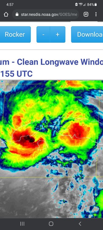
I know its just visual, but the latest satellite imagery makes Ida look like she split into two, and now has 2 LLCs, Twister (the movie) style
-
 1
1
-
-
Amazing. Every sizeable burst of convection is put on the express West to Norther NJ.
Guessing the west hook models where half right. The core may go north but the convection is streaming WNW
Next wave due in about an hour or so.
-
Is there a non-banter thread for Henri? The tropical Headquarters thread is pretty dead.
-
30 minutes ago, STILL N OF PIKE said:
31.2 73.9 is LLC estimate by NHC 45 min ago
Thanks!
-
What's the latest confirmed location on the LLC core?
Channel 13 IR appears to have it peaking through at 30.2 N by 74W ish with the convection making a run at wrap around it.
NOTE: Still learning so know visuals are often deceiving.
-
3 minutes ago, George001 said:
The low is headed right over my backyard. This storm is terrifying, the extreme wind being forecasted in my area remind me of Irene. That was the worst storm I have ever experienced in my lifetime, the wind was so extreme that the trampoline was blown off the ground and started bouncing around my backyard. We lost power for a week, with fallen trees and branches everywhere. My area only got like 2-3 inches of rain, but the extreme wind is what made that storm so devastating in my area.
A trampoline is a horizontal sail. Your average summer thunderstorm can bounce one down the neighborhood, or send it over the trees.
-
1
-
-
The explosion of convection from 14:00Z to 16:00 Z is quite impressive.
-
8 minutes ago, George001 said:
I just looked at the models and it looks like they are taking the low just to the west of my area. Should I start preparing to lose power? I live in the middle of the woods so in big storms I often lose power.
Think you've answered your own question already...
-
1
-
Discussion for a probable 2 or 3 winter storms/events between Tue Feb 11 - Sat Feb 15. OBS threads for each will be added as needed.
in New York City Metro
Posted
That's because there is no CNJ