

WinterStorm294
-
Posts
47 -
Joined
-
Last visited
Content Type
Profiles
Blogs
Forums
American Weather
Media Demo
Store
Gallery
Posts posted by WinterStorm294
-
-
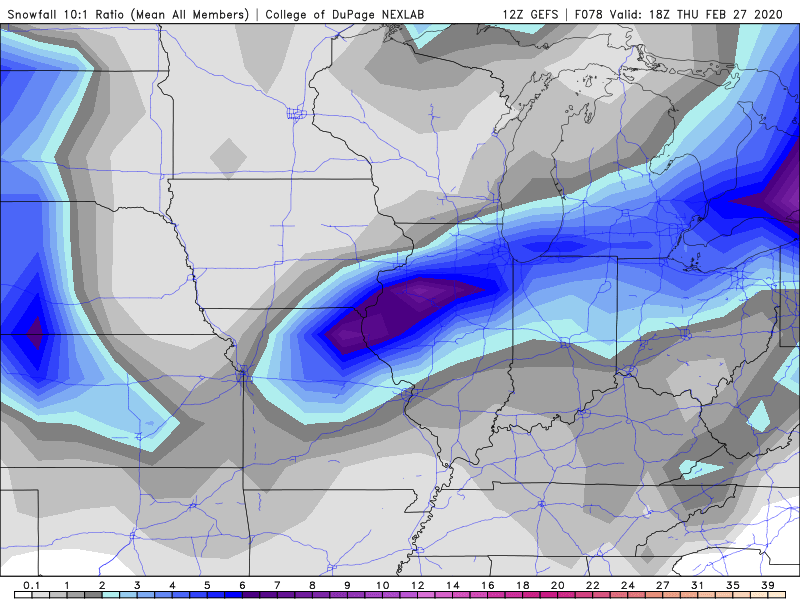
IIRC DTX was thinking 8-10:1 ratios, so the 10:1 map is probably much closer to reality. But still time for a NW adjustment.
-
 1
1
-
-
GEFS are also SE. Not far off from UK.
-
1
-
-
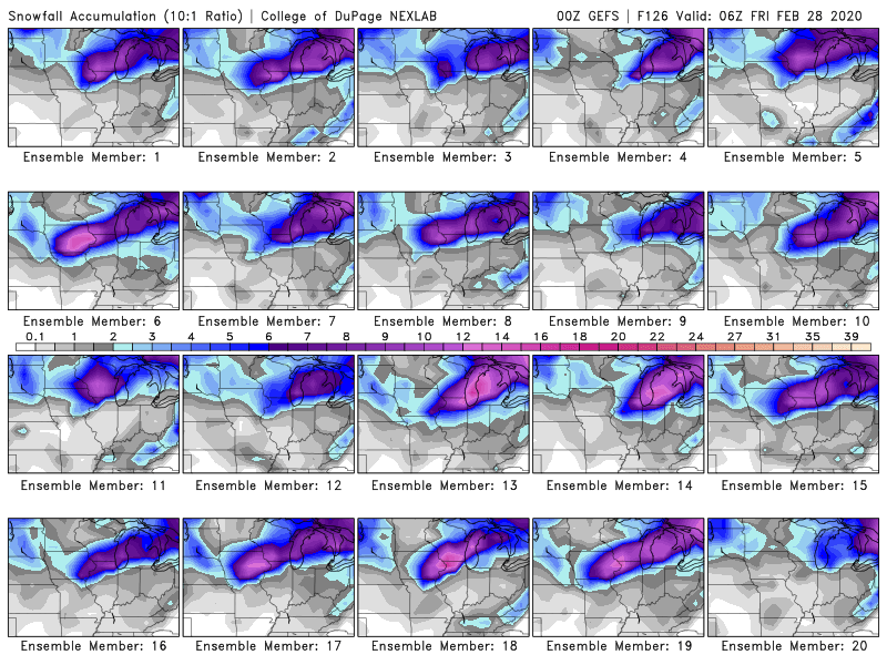
GEFS very similar to 18z. Still plenty of good hits
-
DTX seem pessimistic about this one.
QuoteSo, there remains uncertainty in liquid to snow ratios which causes sensitivity to the bottom line snow forecast. The forecast soundings do not offer a great signal for high snow ratios with a deep isothermal layer (-3 to -4 C) from 4.0 to 10.0 kft which favors needles and columns. Did not change snow ratios much for the warm advection/fgen event and used 9:1 to 11:1. So with a QPF forecast of .25 to .40 inch, continued with a 2 to 4 inch forecast for the event through 18Z Thursday. Current indications suggest an advisory event.
-
 1
1
-
-
18z GEFS are a tick south of 12z...Hopefully op run was just a blip
-
 1
1
-
-
Ice storm warning was a huge bust here. Forecast was for .5 - .75 inches...ended up with a very light glaze and some sleet. Can't say i'm too upset though, it would have been rough with 35+mph gusts.
-
If we had cold air...

-
1
-
-
Finished with around 8.5". Stepping outside this morning it really felt like January.

-
2
-
-
Euro finally caved to the GFS for the Wednesday system. Still looks like a fairly wide band of 2-4/3-5".
-
1
-
-
GFS and FV3 are showing a 3-5" type event for next Wednesday, but the Euro has been much less bullish. Could be a nice refresher after the rain wipes out the remaining snowpack.
-
The 12z Euro had widespread 55-60mph gusts in SMI and into northern IN/OH, which was a solid uptick from the 00z. High winds are fun but i'm not looking forward to a potential power outage.
-
From DTX:
QuoteUPDATE...
The convective snow event, which impacted Ann Arbor and most of metro Detroit (outside of southern Wayne County) produced a swath of 3 to 5.5 inches of snow; most of which occurred over just a two hour period. Some of the peak intensities likely topped two inches per hour. The snow intensified along the nose of a 130kt mid level jet and lead edge of a mid level positive pv feature. The satellite appearance suggested a gravity wave was highly influential. The system intensified right as it moved across Ann Arbor and into metro Detroit. The feature was so strong that there has actually been a mid level subsidence bubble in its wake, briefly ending the snow across far Se Mi.
Picked up around 1.5" here, and had pretty good rates for about 20 minutes. Might grind out another half inch...
-
Euro takes it from STL-LAF-CLE. Nothing like the GFS but there is a narrow band of 6-10".
-
Ended up with ~0.10" of ice, along with probably .75 of sleet. Based on power outages, it looks like GRR had more significant ice.
-
1
-
-
12z Euro upped qpf significantly for SEMI. Wouldn't be surprised to see DTX upgrade some areas to a warning.
-
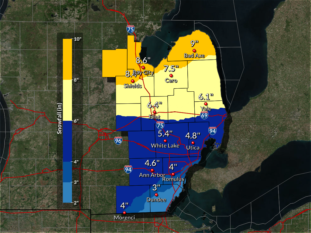
Ended up with just over 6 inches here. DTX map:

-
 1
1
-
-
~3" so far. Radar doesn't look great but should make a run at 6".
-
Not a good start here. Pixie dust even under heavier returns. Maybe an inch so far.
-
10 minutes ago, HillsdaleMIWeather said:
They've been backing off on the dry slotting some, so I think it should be fine knock on wood for you all.
Yeah hopefully they continue to back off. Either way, it should be the biggest snowfall of the season here so far. And we'll have a fresh snowpack which should help to maximize the cold.
-
Euro shifted the heavy snow about 30 miles north in SEMI. Still have hope for a south shift but worried about getting dry slotted like the NAM shows.
-
2
-
-
Any word on the 6z euro?
-
1
-

Mid-week potential of something somewhere
in Lakes/Ohio Valley
Posted
GFS with 2-4" in SEMI