

NeffsvilleWx
-
Posts
6,871 -
Joined
-
Last visited
Content Type
Profiles
Blogs
Forums
American Weather
Media Demo
Store
Gallery
Posts posted by NeffsvilleWx
-
-
Recon is back on the ground per ADSB data. Wonder what happened.
-
Going to be a bumpy ride for recon. Hopefully they don’t end up in a Hugo situation — which occurred during a period of RI.
-
 1
1
-
-
14 minutes ago, rygar said:
You argument is that the word "strong" is better than a + sign. There is no difference, both convey a hurricane with winds higher than the cat 5 minimum standard
No, my argument is that the "+" implies numbers greater than 5 exist. For a public that already struggles with basic weather stuff, let's not further muddy the waters when we know better.
-
2
-
 2
2
-
-
11 minutes ago, so_whats_happening said:
Latent heat release can be rather large and intense in strong systems so they tend to not be modeled all that well and some key things can get missed. That is the idea of a mind of its own because it can change up the atmosphere around the system given the right conditions.
Just like in winter sometimes the thunderstorms off the east coast can be misrepresented thus leading to a stronger ridge than modeled.
Interesting, thanks. I'm assuming this can have big impacts on steering and thus path?
OT: How's Centerville Road traffic with all the construction? We left in August of 2021 shortly before it started. I graduated from Penn Manor, shadowed Horst on career shadowing day in middle school during construction of the current building and top floor lab, attended MU for meteorology for about a year before my immaturity led to dropping out -- Millersville is my old stomping grounds).
Now instead of watching hurricane impacts from behind a screen, I'm living them. Thank god for post-Andrew building codes, shutters, block houses, a bit of elevation, and a whole home generator.
-
7 minutes ago, Windspeed said:12 minutes ago, NeffsvilleWx said:
I really want to know what the + means in 5+.
He probably just means significantly above the 135 kt threshhold. I mean, if Lee were to reach MPI after the first EWRC, it could get down in the 910s. A 150 kt storm is not impossible with this setup. I'm not calling for that as there can always be unexpected variables, but he probably thinks it will.
The "+" is unnecessary sensationalism and not even a "thing." Just call it a strong cat 5. Draw a comparison to Camille or something. Don't make shit up for effect, it makes you look dumb.
-
5
-
-
33 minutes ago, nycsnow said:
I really want to know what the + means in 5+.
-
 2
2
-
 1
1
-
-
5 hours ago, WxWatcher007 said:
It looks like there’s a strong TC genesis signal suggesting long track potential in the MDR, but honestly, given how the models have struggled so much with the steering pattern for Franklin and now with Idalia’s long term track I don’t put a lot of stock in having any sense of steering for maybe another week.
Aside from the timing (ie - imagine the steering pattern solutions were more reliable) -- is my overall take accurate?
-
3 hours ago, Wannabehippie said:
Hurricane Josh successfully penetrated the eye of Idalia.
Really surprised to see him so soon after the storm.I guess there weren’t any minority families around to exploit… I mean to help boost his image/brand… I mean help.
-
1 hour ago, cptcatz said:
Euro, CMC, Icon, and UK all show MDR development in 5 days. I wonder when we get a new lemon. This looks like it could be a long tracker ACE maker.
Caveat: not that knowledgeable about tropical dynamics.
On the euro: It looks like there's quite a bit of shear present north of the Caribbean at 216. And that mid level trough extending to the tip of Fl seems like it'd keep it out of the Gulf and away from the eastern seaboard. Though by 244 looks like that trough might be breaking down.
Someone with more knowledge care to chime in?
-
1
-
-
13g29. Big nothingburger here in Melbourne. Which, being on the outside edge of the TS warnings is about what I expected.
-
7 minutes ago, Master of Disaster said:
There is zero possibility that eye is 20 miles across imo. The eye contracting has been noted for at least two hours. Anyone have a way to measure the distance from eye wall to eye wall? I am curious if sat and radar actually show this or if it just looks that way?
I'm measuring radius of about 6 miles at an altitude of about 16k feet per TBW radar
-
2
-
-
3 minutes ago, beanskip said:
Yeah I know.
I guess my point is, when's the last time you can remember an NHC cone where at 30 hours the CMC is 100 miles outside the cone and the GFS is outside it or just straddling its edge?

NHC possibly thinking that some land interaction is going to pull it a bit east? Not sure that sort of nuance is captured in models.
-
5 minutes ago, turtlehurricane said:
We had some decent flooding rains in Miami today on the outer-edges of Idalia.
I think the coming day could be very interesting as the Hurricane makes its closest approach, probably will get alot of strong rain bands across all of Southeast Florida. The WPC forecast via the NHC says 2-4 inches of rain are coming, and NHC says we should see 35 mph gusts during the height of it.... it's just enough that they've been issuing Hurricane Local Statements for the area.
Anyone else noticing the trend that's developed, with Idalia circling back and then hitting South Florida from the east in about a week https://moe.met.fsu.edu/cgi-bin/gfstc2.cgi?time=2023082818&field=Sea+Level+Pressure&hour=Animation
This happened once before in my life with another TC that I don't remember off the top of my head, and it'll probably be a weak tropical storm at that point, if it happens at all.
got some rain up here in Melbourne as well. And the local statements with bonus TS watch. Not really expecting anything more than a breezy, rainy day. -
14 minutes ago, BYG Jacob said:

Pressure dropping like a rock
And -10 mb from model guidance assuming 979 is accurate.
Edit: not sure if I believe it. NOAA marked the eye an hour ago at 988. Wilma has the record for pressure frop @ -4.2 mb per hour. I'm gonna go out on a limb here and say either this is unprecedented or the data is invalid. Because it's not even in the eye so one would expect the pressure to be even lower.
-
8 minutes ago, Covidea said:
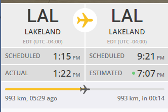
The men and women who fly these recon flights must be amazing people. This is from Flightradar24.com and shows the aircraft currently out there.

They all know where each other is — and they’ve got regional airspace coordinators keeping an eye out.
-
32 minutes ago, dan11295 said:
Guidance has been consistent or more or less keeping Idalia in check into shear lessen N of Cuba later tonight/early tomorrow.
You could see the sheer impact this morning as an outflow boundary from collapsing convection shot out to the east.
-
Just received this:
Tropical Storm Idalia Local Statement Advisory Number 5 FLZ041-044>046-053-058-141-144-154-159-164-247-254-259-264-347-447-547-647-747-280430- Tropical Storm Idalia Local Statement Advisory Number 5 National Weather Service Melbourne FL AL102023 615 PM EDT Sun Aug 27 2023 This product covers East Central Florida **Tropical Storm Watch In Effect for Lake County** NEW INFORMATION --------------- * CHANGES TO WATCHES AND WARNINGS: - A Tropical Storm Watch has been issued for Northern Lake and Southern Lake * CURRENT WATCHES AND WARNINGS: - A Tropical Storm Watch is in effect for Northern Lake and Southern Lake * STORM INFORMATION: - About 640 miles south-southwest of Leesburg FL - 20.1N 85.5W - Storm Intensity 40 mph - Movement Northeast or 40 degrees at 3 mph SITUATION OVERVIEW ------------------ The center of Tropical Storm Idalia is located just over 120 miles south of western Cuba this afternoon. Idalia is slowly drifting to the northeast, and motion is expected to remain slow and possibly erratic overnight, before increasing in speed to the north-northeast on Monday and Tuesday. The storm is currently forecast to approach the western Florida Peninsula late Tuesday into Wednesday. Preparations should be ongoing for at least tropical storm conditions by midweek. A Tropical Storm Watch is now in effect for Lake County, where confidence is highest in tropical storm conditions occurring. Additional watches may be necessary for portions of east-central Florida in future forecasts. Moisture associated with Idalia will reach central Florida as early as Monday afternoon, boosting rain and thunderstorm chances during the day. Conditions will begin to deteriorate Tuesday afternoon and evening as Idalia accelerates north-northeastward across the eastern Gulf of Mexico. As coverage of showers and squalls increases Tuesday afternoon into Wednesday, the possibility of strong to damaging wind gusts will also increase. Tropical storm force winds are forecast to extend outward from the storm`s center, potentially reaching portions of east-central Florida, including Lake County, Tuesday night into Wednesday morning. Based on the current forecast track, Idalia will make its closest pass to east-central Florida late Tuesday night and Wednesday morning, continuing northeastward during the day on Wednesday. While the heaviest rainfall from Idalia is currently forecast to fall along the Gulf Coast and western Florida Peninsula, gusty squalls will be capable of torrential downpours, especially Tuesday and Wednesday. One to two inches of rain from Monday afternoon through Wednesday night is expected for a large portion of the area, with locally higher amounts possible. Locations in closer proximity to the center of Idalia, such as Lake County in east-central Florida, may receive higher rainfall totals. In addition to strong wind gusts, a threat for tornadoes is forecast to develop as the center of Idalia moves into the eastern Gulf of Mexico Tuesday afternoon, Tuesday night and into Wednesday. Combined swells from Hurricane Franklin over the western Atlantic and the approach of Idalia will likely lead to high seas, rough surf, and an increase in life-threatening rip currents. Eastward adjustments to the current forecast track would also increase the threat for possible beach erosion and coastal flooding Tuesday into Wednesday. Do not let your guard down, especially in locations east of the current Tropical Storm Watch. Impacts from Idalia will be experienced far from the center of the storm. Now is the time to ensure your hurricane supply kit is stocked and your safety plan is in place. As Idalia becomes better organized over the next 24 to 36 hours, additional changes to the current forecast are possible. Eastward shifts in the forecast track would increase the potential for impacts locally, so continue to monitor the latest forecasts from the National Hurricane Center and National Weather Service in Melbourne, Florida. POTENTIAL IMPACTS ----------------- * WIND: Prepare for hazardous wind having possible limited impacts across East Central Florida. Potential impacts include: - Damage to porches, awnings, carports, sheds, and unanchored mobile homes. Unsecured lightweight objects blown about. - Many large tree limbs broken off. A few trees snapped or uprooted, but with greater numbers in places where trees are shallow rooted. Some fences and roadway signs blown over. - A few roads impassable from debris, particularly within urban or heavily wooded places. Hazardous driving conditions on bridges and other elevated roadways. - Scattered power and communications outages. * FLOODING RAIN: Prepare for dangerous rainfall flooding having possible significant impacts across Lake County. Potential impacts include: - Moderate rainfall flooding may prompt several evacuations and rescues. - Rivers and tributaries may quickly become swollen with swifter currents and overspill their banks in a few places, especially in usually vulnerable spots. Small streams, creeks, canals, and ditches overflow. - Flood waters can enter some structures or weaken foundations. Several places may experience expanded areas of rapid inundation at underpasses, low-lying spots, and poor drainage areas. Some streets and parking lots take on moving water as storm drains and retention ponds overflow. Driving conditions become hazardous. Some road and bridge closures. Prepare for locally hazardous rainfall flooding having possible limited impacts across the remainder of East Central Florida. * TORNADOES: Prepare for a tornado event having possible limited impacts across East Central Florida. Potential impacts include: - The occurrence of isolated tornadoes can hinder the execution of emergency plans during tropical events. - A few places may experience tornado damage, along with power and communications disruptions. - Locations could realize roofs peeled off buildings, chimneys toppled, mobile homes pushed off foundations or overturned, large tree tops and branches snapped off, shallow-rooted trees knocked over, moving vehicles blown off roads, and small boats pulled from moorings. * SURGE: Direct surge impacts from Idalia are not currently anticipated at this time. However, larger swells and surf combined with Hurricane Franklin will bring a threat for minor coastal flooding and beach erosion.Locations more vulnerable to coastal flooding and beach erosion, such as portions of the Volusia County coast, should stay updated on the latest forecasts. PRECAUTIONARY/PREPAREDNESS ACTIONS ---------------------------------- * EVACUATIONS: Listen to local officials for recommended preparedness actions, including possible evacuation. If ordered to evacuate, do so immediately. * OTHER PREPAREDNESS INFORMATION: Now is the time to check your emergency plan and emergency supplies kit and take necessary actions to protect your family and secure your home or business. When making safety and preparedness decisions, do not focus on the exact forecast track since hazards such as flooding rain, damaging wind gusts, storm surge, and tornadoes extend well away from the center of the storm. When securing your property, outside preparations should be concluded as soon as possible before conditions deteriorate. The onset of strong gusty winds or flooding can cause certain preparedness activities to become unsafe. Closely monitor weather.gov, NOAA Weather Radio and local news outlets for official storm information. Listen for possible changes to the forecast. There is a threat from tornadoes with this storm. Have multiple ways to receive Tornado Warnings. * ADDITIONAL SOURCES OF INFORMATION: - For information on appropriate preparations see ready.gov - For information on creating an emergency plan see getagameplan.org - For additional disaster preparedness information see redcross.org NEXT UPDATE ----------- The next local statement will be issued by the National Weather Service in Melbourne FL around 12 AM EDT, or sooner if conditions warrant. $$ Schaper -
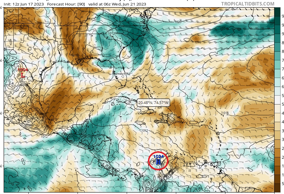
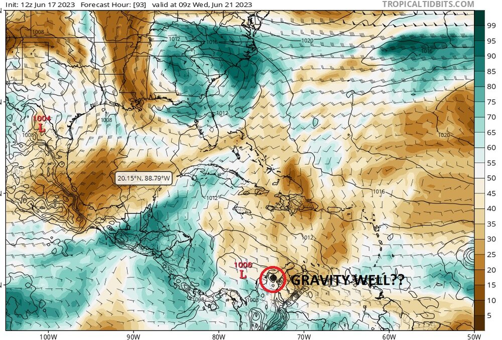
I don't trust the euro output.
It's got a 102x mb high parked right over venezuela for the entire model period that really just doesn't really move save for a few spurious changes (including 1 panel at hr 69 where it changes to a 1007 mb low before changing back to 102x high on the next panel). Looks to be right over Pico Cristobol Colon.
I'd think if it were accurate, there'd be a little bit of panel to panel wobble to that high. Or maybe I'm just an idiot. That's certainly possible.
-
-
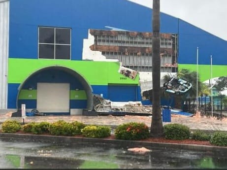
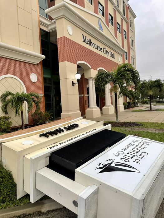
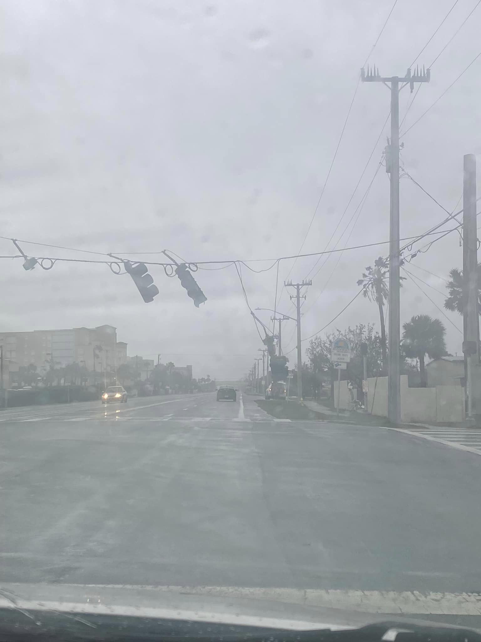
First building damage I've heard of - Andretti Thrill Park in Melbourne
-
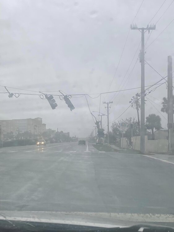
Almost 25% of consumers in Brevard are without power per Brevard emergency management.
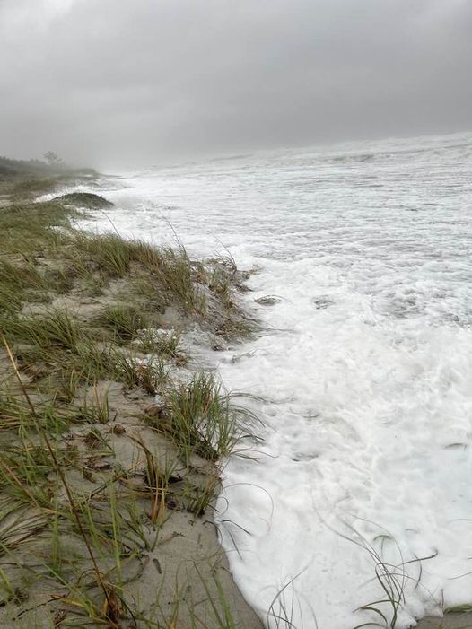
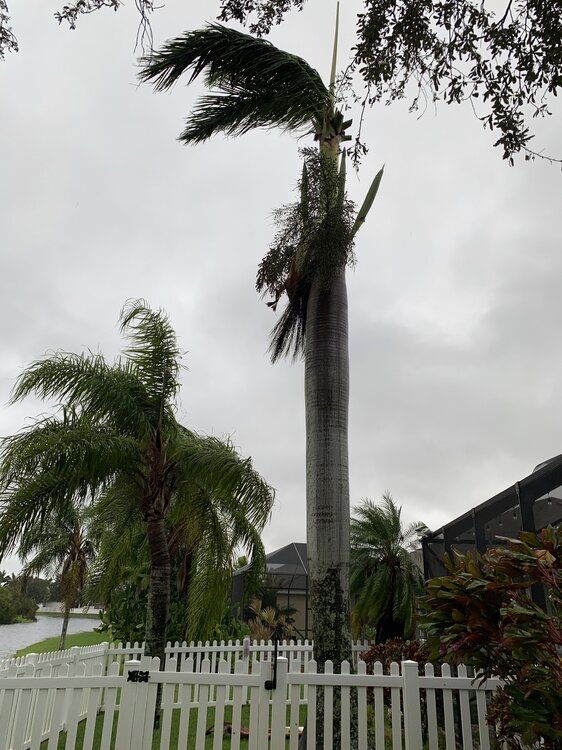
Some other photos/videos from local social media pages:
-
1
-
-
Between Ian and Nicole, my Royal Palm is looking pretty sad. Just pulled the shutters back, suns out now.
-
8 hours ago, Normandy said:
any good radar sites
Not free, but GrLevel3 ($89.99) for PC and Radarscope ($9.99) for mobile are pretty much cream-of-the-crop when it comes to radar data.
-
1
-
-
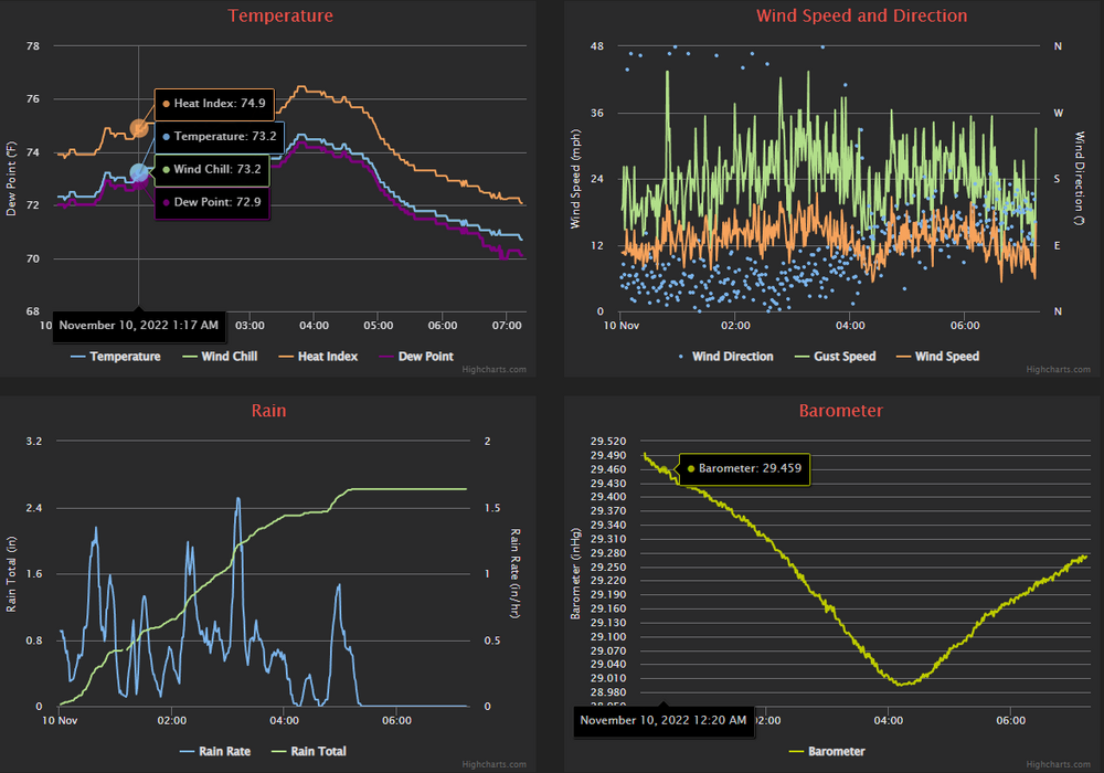
Nothing too exceptional here. Max gust of 37 kts, max sustained of 18 kts. My sensor is not ideally located but I'm at the mercy of the HOA.
Between Ian and Nicole, our large foxtail palm in the back is down to 2 fronds. I'll have to hit it with some fertilizer this weekend. Have a branch down from a live oak in the back, too. 3/4-1" diameter if I had to guess. Maybe a bit more. Overall, about what I expected.
No idea what the front of the house looks like yet, that's all boarded up.


Category Five Hurricane Lee
in Tropical Headquarters
Posted
Cells are an average value of all their contents. If a cell has pressure values of 1024, 1028, 1010, 1015, and 948, then that cell will be given a value of 1005. Even though there's a 948 mb low in there.
There's probably some fancy math nuance to it that mets could chime in on, but I believe this is the gist of it (cell dimensions vary by model).