

thunderwolf
-
Posts
127 -
Joined
-
Last visited
Content Type
Profiles
Blogs
Forums
American Weather
Media Demo
Store
Gallery
Posts posted by thunderwolf
-
-
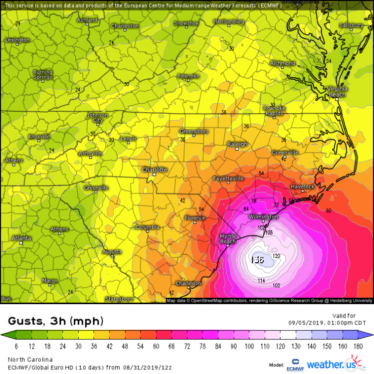
The 3k NAM is a bit overdone for inland locations I think. It is overamped and I think a track that far inland is an outlier. Right now, I think the 60-70 mph gusts will be contained to the US 17 corridor and eastward for NC. If anyone sees hurricane gusts, I think it's going to be directly along the coast. The ECMWF may have the track right, but those gusts maps have been 10-20% higher than verification for the majority of areas during recent storms the past couple of years.
-
 1
1
-
-
54 minutes ago, FLweather said:
I'm beginning to have my doubts about Dorian being captured and pulled north.
Looking at current WV. Looking at what's in the GOM.
The trough too flat and stable to be to be pulling Dorian north much.
I like looking at current observational trends as much as the next guy, but not a single GFS or ECMWF ensemble shows this. While I am always leery of the models in a stalled tropical system scenario, the amount of agreement we have between all the reliable models makes me much more confident that we will see a northward movement tomorrow. I think the question going forward is whether we will see a landfall in the Carolinas. Models have been waffling back and forth by 10 miles or so with no clear trend either way.
-
1
-
-
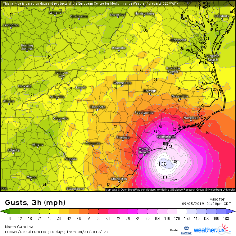
1 hour ago, NC_hailstorm said:
Still some 40mph gusts getting back in the W.Piedmont on the Euro.Higher the further east you go.
Just an FYI, based on my experience with tropical systems the past few years, these maps tend to be over done by 10-20% vs what ends up verifying.
-
Finally got cold enough to get some decent snow here in southern Wake and I thought we might be able to squeak out an inch after all. But then radar returns completely fell apart just as it was getting going. Sun trying to peak out now
Sent from my XT1635-01 using Tapatalk -
It's such a different landscape over a short distance on 401. Wake tech has pretty good snow and people sliding off that hill. Just a little slush near that sheetz and Bojangles and just wet by the food lion.I can't wait to see the official snowfall map for this system and see the cutoff for zilch a mile from my house.
Sent from my XT1635-01 using Tapatalk
-
1
-
-
Mainly rain with some sleet mixed in in southern wake
Sent from my XT1635-01 using Tapatalk -
Southern wake, mainly sleet and a little snow. 1.2 on the ground 1.5 on top of the car
Sent from my XT1635-01 using Tapatalk -
24 minutes ago, Solak said:
Yea, I don't think that's legit. At least I really hope it isn't.
-
1
-
 1
1
-
-
53 minutes ago, SnowGoose69 said:
95% of Carteret County is already out of power. That is crazy high given winds only topping 55-65 so far
Just wanted to let you know that those numbers might be inflated slightly. I think the power outage source either a) doesn't have the total number of customers correct or b) is wrongly assuming all Carteret-Craven Electric Coop is out of power which it is not. My parents live there and have CCEC and still have power.
-
8 minutes ago, Ralph Wiggum said:
Isnt surge more a function of kinetic energy, overall expanse of windfield, and longetivity of onshore flow rather than just S-S scale? Also many area will go thru several tide cycles with the same or similar wind trajectory?
You are absolutely right, but wind speed is also a factor. None of the other factors have changed and so now with a decreased wind speed we are expecting less surge. And by less surge, I think the forecast only went down by about a foot, so we are really splitting hairs here.
-
2
-
 1
1
-
-
8 minutes ago, Ralph Wiggum said:
Its odd the surge potential was lowered/decreased no? Seems to me trend on guidance is an even slower Florence and more time centered over water before a LF. Just thought it was odd that they would lower the threat with the general public focusing on surge potential and based on what we are seeing already in spots at slack low tide attm that are completely inundated. Hope nobody is breathing a sigh of relief reading that info.
You mentioned the bad things, so I will point out a couple of good things regarding potential surge. 1) Storm is weakening and pushing less water 2) Looks like landfall will be around low or at least mid-tide tomorrow.
-
1
-
-
Looks like after that reorganization of the eye that its drifting northwestward again.
-
2 minutes ago, yotaman said:
Eye looks to be wobbling a lot but seems to be generally moving wnw. Anyone else see this?
I can agree with this assessment. NHC still shows the movement as of the 1pm update NW at 10 mph.
-
2 minutes ago, Steven_1974 said:
There's no way the eye is 140 miles wide. That would be greater than the distance from Wilmington to Raleigh which is only 114 miles.
Just measured the satellite, it looks like its about 35 miles wide N-S.
-
7 minutes ago, mackerel_sky said:
High Risk excessive flash flood risk , issued by WPC! It’s only the 2nd time it’s ever issued one of those!! The 1st one was issued for Harvey!!
Maybe a Day 3 high risk, but there has been several Highs Risks issued by the WPC this year. In fact they issued one as the remnants of Gordon combined with a cold front of the OH Valley this past weekend.
-
Well we had good agreement between the GFS and ECMWF for about 1 hr.
-
1
-
 1
1
-
-
2 minutes ago, downeastnc said:
That was a decent NE jump at 48 hrs...honestly surprised me thought it might be going to end up Jacksonville/MHX

Pressure 10 mb higher too. Not sure what I think about that, although nearly all the models have been trending slightly weaker with the system which is good news.
-
7 minutes ago, Dunkman said:
Point stands though it's still a large spread at 84 hours.
Yes the landfall probability distribution seems reasonable to me. <10% chance of OTS, about 10% of moving into GA, 20% chance Charleston area, 60% from about MYB to MHC.
-
3 minutes ago, DopplerWx said:
that is yesterday's run
Wow, good call. I don't know how to post the image of today's run, but here's a link https://www.weathernerds.org/tc_guidance/images/AL06_2018091012_ECENS_0-120h_large.png
Spread does seem a little more reasonable with today's 12z than the one I had erroneously mentioned earlier.
-
26 minutes ago, StormyClearweather said:
EPS, FWIW:

Wow that is a lot of spread between one model's ensemble members. There are even a few GFS like runs in there too.Edit: That was yesterday's run. Spread does look more reasonable today.
-
Quote
Jonathan Wall tweeted about 30 mins ago that the latest 3k Nam everyone is falling apart about its wrong if you want to go check it out. I saw that the quiet Eric Webb retweeted it.
Hug the big dog outlier until it falls in line with the rest of the models. Then when that model comes into line with everything else, its "falling apart".
-
2
-
-
What is the HRRR smoking? Its still giving close to 10 inches in the triangle.
-
3 minutes ago, Supercane said:
Yeah the usual NW trend really screwed us over. The HRRR and NAM are interesting enough to keep watching in the very slim chance this overperforms -- but no reason to expect more than an inch of snow (and extra sleet) in the southern half of Wake given the issues you outlined, imo.
I think the GFS just put any hopes of overperforming to bed.
-
Just now, Cold Rain said:
It's just cause I live here.
Well maybe if you deactivated you "show" shields we would get in on the action down here!


Dorian Observations
in Southeastern States
Posted
Hmmm, I wonder what happened in 1996?