

OKStorm
-
Posts
61 -
Joined
-
Last visited
Content Type
Profiles
Blogs
Forums
American Weather
Media Demo
Store
Gallery
Posts posted by OKStorm
-
-
-
4 hours ago, DanLarsen34 said:
Just did a scan of twitter. It seems most of the damage pictures circulating are in this specific area. https://twitter.com/jeff_paul/status/1132697731556937729?s=21
The tornado in El Reno was quick and on the ground for only a short distance.
-
Lets keep the back and forth arguing on another tread. Actual event related information from here on out.
-
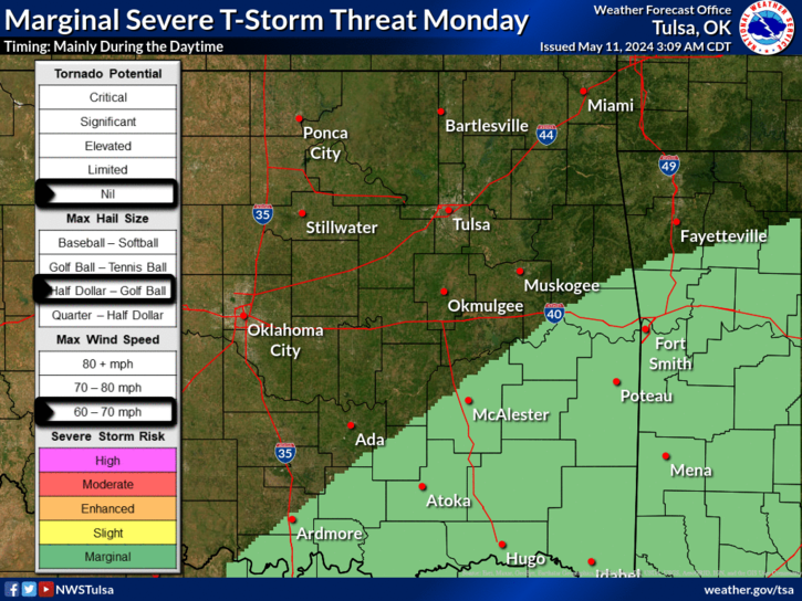
Area Forecast Discussion
National Weather Service Tulsa OK
251 PM CDT Sun May 19 2019

...Significant severe weather expected Monday with the threat
   for strong tornadoes...

...Flash flooding possible across NE OK Monday/Tuesday...

.DISCUSSION...
Pleasant conditions this afternoon, but this will quickly change
with very active weather anticipated Monday into Tuesday. Potent
upper trough will move out of the desert southwest on Monday. In
response warm front will lift into northeast Oklahoma Monday afternoon.
Along/south of warm front, very unstable conditions expected with
large looping hodographs. Main question at this point is when the
stronger convection develops and how this impacts the northern
progression on warm front. Most CAM solutions have boundary lifting
to at least I-40 and quite possibly to the Oklahoma/Kansas border.
There will be the potential for training supercells near boundary
by Monday afternoon and with limited CIN a few isolated supercells
will also be possible in the warm sector. Given this scenario,
strong/long track tornadoes will be possible with cells that can
remain discrete. In addition, very heavy rainfall is expected with
these storms across northeast Oklahoma with the potential for flash
flooding. A flash flood watch was issued earlier this afternoon
which will be in effect Monday morning through Tuesday afternoon.
Still expect an axis of heavier rainfall that will impact south-
central/southeast Kansas which will likely cause high flows along
the Arkansas river and the Neosho at Commerce.

Main upper storm system will lift northeast into Kansas on Tuesday
with line of strong to severe storms likely sweeping through
eastern Oklahoma Tuesday morning, moving into northwest Arkansas
by early afternoon. Very strong low level wind fields are progged
during this time and even with modest instability, the threat for
QLCS tornadoes/damaging winds are expected, especially east of
highway 75 where the highest instability develops.

Strong upper high builds over the southeast CONUS by mid to late
week. Could still see scattered showers/thunderstorms through the
remainder of the extended periods, mainly across northeast
Oklahoma on the periphery of upper high/stronger southwest flow
aloft.
-
I do not think it ever lifted and am surprised KGWX stayed on the air.
-
 1
1
-
-
Another issue for search and rescue in AL.


-
It is not like there is really warm air in the area, it is cold well south at this time.
-
3 hours ago, StormChazer said:
I will not get excited about next weekend. I will not get excited about next weekend. I will NOT get excited about next weekend.
COPES can help you through this........
-
Read about the typhoon out near Guam. Said that a February typhoon had not hit there since 1953 which was a weak El Nino at the time. Looked at tornadoes in 53 and there were some very significant events. So we will see but maybe not so slow this year.
-
Just cancel this thread. It snowed in Malibu for crying out loud but Tulsa noooooo.
-
1
-
 2
2
-
-
I am so tired of the just too shallow cold around here. I am ready to move onto spring.........
PREV DISCUSSION... /Issued 307 AM CST Sun Feb 17 2019/

DISCUSSION...
Cold front currently moving through southeast Oklahoma into far
northwest Arkansas early this morning. Areas of freezing drizzle
will start to tapper off over the next couple hours, but still
some slick spots on area roads, especially northwest of Tulsa.
Skies are expected to clear from northwest to southeast this
morning with mostly sunny skies this afternoon.

Cold conditions will continue tonight into Monday morning as surface
high pressure builds into the region. Complicated forecast expected
on Tuesday, with multiple precip types possible, as upper level
storm system moves into the four corners region. Areas of rain/
freezing rain/sleet are expected to spread north Tuesday morning
given strong lift in association with right rear quad of upper
jet. Temperatures will likely hold or fall to around freezing as
precip develops through the day. Best chance for rain/freezing
rain to transition to snow will likely be in areas north and west
of Tulsa, however point soundings indicate saturation may not
occur in favored dendritic growth zone. Any winter weather threat
will end Tuesday night as upper jet streak lifts northeast.

Still some differences concerning evolution of upper wave moving
out the Baja region Wednesday into Thursday. GFS is more aggressive
with wave, with another round of overrunning precip during the
day Thursday. ECMWF keeps heavier rain well east of the area during
this time, with significant warmup into Friday. Better rain chances
are expected by Saturday as main upper low approaches. Given uncertainties
in the exact track, will continue with chance pops through the remainder
of the extended periods.
-
1
-
-
Tulsa still going with mostly rain event for Tulsa metro.
-
Good Morning Oklahoma today is pick and choose day

-
3
-
-
1 hour ago, garfan said:
Do you ever mention severe weather in this thread when it's occurring during winter?
We would but we never get winter in OK anymore only only temps going between 15-20 and 75-80 all in a couple of days.
-
3
-
 2
2
-
-
High Risk May 4th I am going with 1301 for the year maybe with the end of the drought in OK things will get going again.
-
-
1 hour ago, westhope84 said:
Whoa. If the Euro is even half right, Tulsa NWS and all area meteorologists will need to make some huge changes to the forecast quickly.
Is anyone buying the Euro solution for snow in Tulsa?
Does not appear so TSA calling for less than one inch in Tulsa at this time. Going for the rain over snow or ice.
-
1
-
-
Rain moved thru Tulsa to the west in Creek Co bridges iced up very slick. Precipitation ended in west Tulsa for now showing 30 on the dash.
-
TSA not biting on snow for Tulsa Metro.
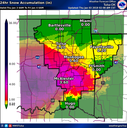
Area Forecast Discussion
National Weather Service Tulsa OK
407 PM CST Wed Jan 2 2019

.DISCUSSION...
Complicated forecast this afternoon with ongoing areas of light
freezing rain or freezing drizzle in parts of eastern OK and
northwest AR that prompted a Winter Weather Advisory earlier
today. Surface temperatures have gone virtually nowhere as warm
conveyor precip continues to spread north up to near I-44 with a
sharp cutoff on the northern edge. Temps are and will likely
remain below freezing from about McAlester to Eureka Springs with
slight moderation possible later tonight. Although short-wave
ridging aloft will be over the are tonight, a near saturated layer
will persist up through around 850mb per high res model
soundings, thus while threat of measurable rainfall will
eventually shift east, some patchy areas of freezing drizzle
cannot be discounted. Thus have extended the Advisory into
Thursday morning, as some slick overpasses have been reported.

Potent upper low currently centered west of ELP will continue to
move east Thursday, with a track somewhere in the vicinity of the
Red River. Precip will begin to increase Thursday morning into the
afternoon as the low moves east. Freezing remain potential during
the morning will persist, and concern is that temperatures will
not moderate much at all in the vicinity of heaviest precip band
which is currently expected to set up close to the I-40 corridor.
If temps remain cold enough a band of significant ice accumulation
may set up and this will need to be watched closely. By afternoon
most if not all locations should finally warm above freezing but
again this is no guarantee where heaviest precip falls. For now
will handle the potential with extension of existing Advisory.
Areas in closer proximity to the upper low track will eventually
see enough cooling through deeper layer to result in a chance to
snow, with some potential for accumulations mainly across
southeast OK in elevated terrain.
-
4 hours ago, StormChazer said:
Thank you. To add some more hope. Tulsa has NEVER gone 7 years in a row without breaking double digits in a year and has gone 6 years in a row with less than 10 inches per year only 3 other times since record keeping.
The first time, 1907-1912, only to get 18.2 inches in 1913.The second time, 1931-1936(Dust Bowl), went on to get 14 inches in 1937.
The third time, 1938-1943(Dust Bowl/leftover drought), received 15.3 inches in 1944.
And now 2012-2017, I've got to think based on history that 2018 delivers 10+ inches. I don't want to break a record for longest streak of <10 inches ever recorded for Tulsa.
Just plain ugly stats not to mention it snowed in Houston, New Orleans and now Fla today. Cancel winter now and get onto spring storms........
-
If the drought continues to intensify in OK I have my doubts on a decent spring. I am going for 1050 total and the first high risk on March 7 in the Dixie area.
-
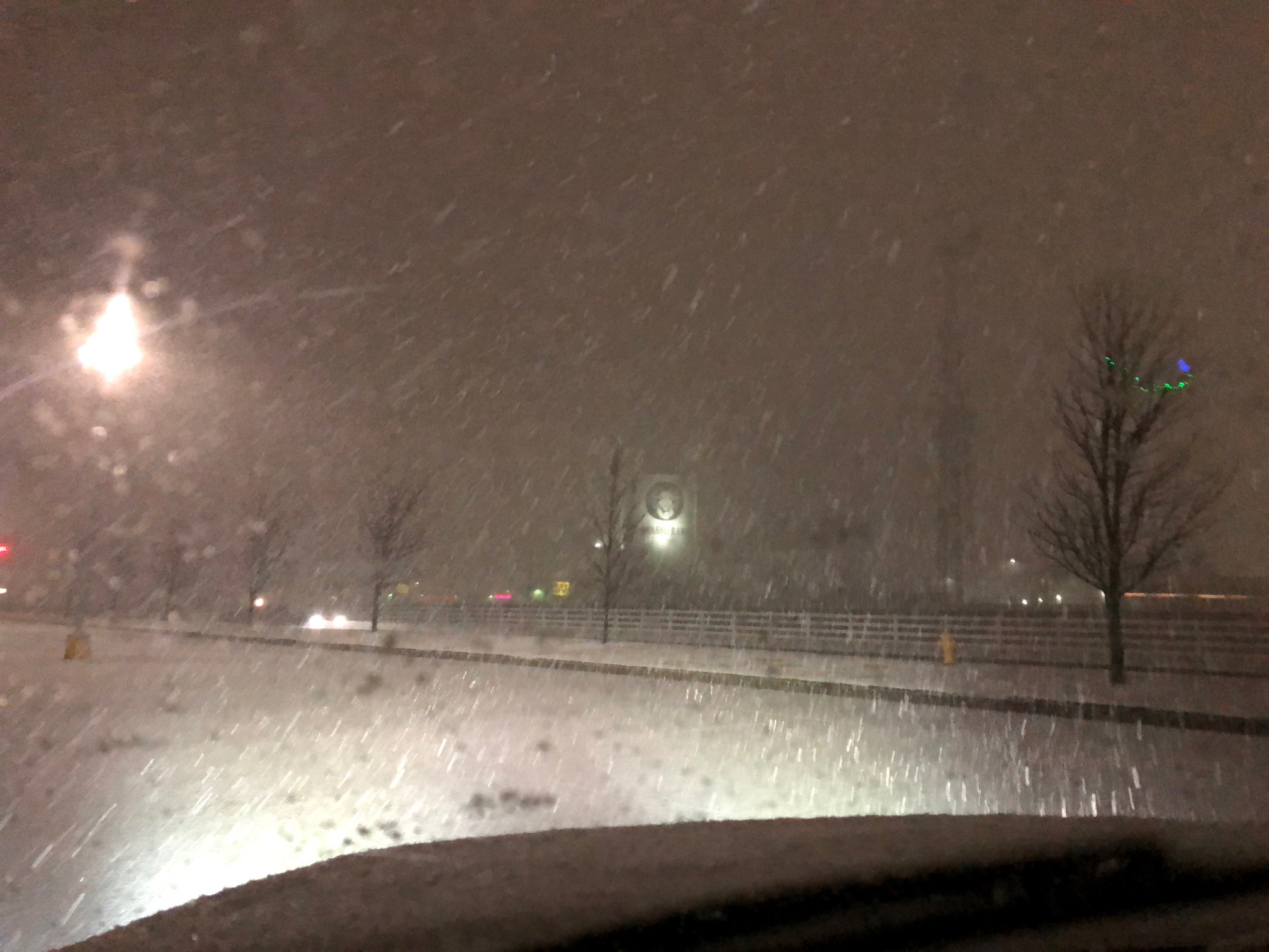
Had a nice burst of snow in Owasso last night about 2330 hours as the rain finally changed to all snow.

-
2
-
Predict/Guess the Number of Tornadoes and the First High Risk of 2020
in Central/Western States
Posted
Just as a side note we started with a cool spring in OK but set the yearly record with 147 tornadoes. Granted only one was a EF3 but it was a wild few weeks as it was happening.
.