

CO SciFan
-
Posts
74 -
Joined
-
Last visited
Content Type
Profiles
Blogs
Forums
American Weather
Media Demo
Store
Gallery
Posts posted by CO SciFan
-
-
Here the temperature falling off the cliff in Laporte earlier today. Impressive cold!

Sent from my SM-G998U1 using Tapatalk-
 1
1
-
-
Having scary memories of the Fort Collins 1997 flood, which happened on this date. We have had pretty constant training t-storms with heavy precip since yesterday with a few breaks here in Laporte which is where 97' got going. Some really impressive hail across the area last night as well. This Twitter thread is sobering (see second post too):
-
We've barely had any precipitation so far here. Hoping we can still get some good moisture and holding out hope for the next phase.
Sent from my SM-G998U1 using Tapatalk -
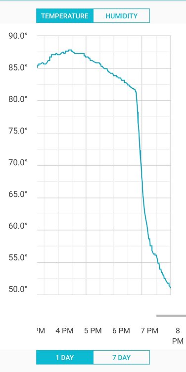
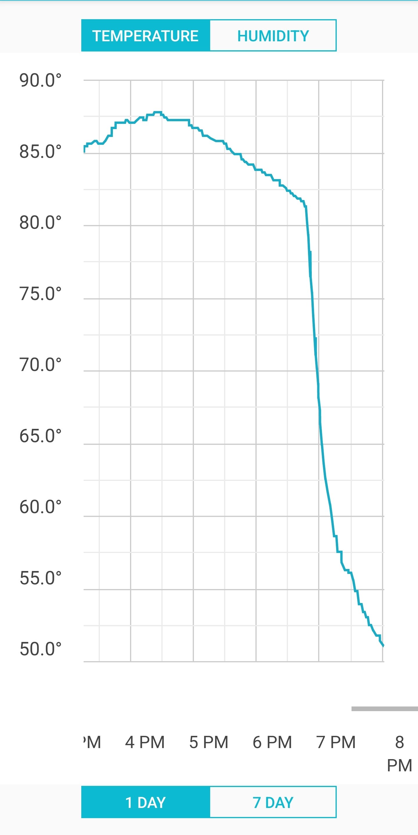
Wow, I was outside winterizing the garden and it was like I could feel the instant the front arrived and my temps plummeted around 25 degrees in 20 minutes. Here's the graph from my backyard:
-
2
-
 1
1
-
-
5,105 ft and close to the foothills in Laporte.
Sent from my SM-G998U1 using Tapatalk -
We just finished planning a ton of stuff and I am not super excited about protecting it all from frost. Any odds for a late freeze for FOCO/Laporte at this point? Seems like the models are still divergent, especially on low temps.
-
We've had light snow for most of the day in Laporte, but things are starting to get going more now with a solid light snow. Hoping for over a foot here in our location close to the foothills!
-
1
-
-
Spann texting his wife to get to safety, yikes.
-
Sorry I missed we have an actual storm-dedicated thread! It's fairly cranking in Laporte over the last twenty minutes but still fairly warm at 35ish degrees. I wonder if Laporte will get a bit more than Fort Collins being a tad higher and closer to the foothills, or will the Cheyenne Ridge keep that from happening? We recently moved from central Fort Collins to basically the middle of Laporte and it's amazing how much louder the lightning is against the foothills and how different the weather can be here than just a few miles away in town.
-
Finally starting to dump fairly well here in Laporte. It turned to snow about an hour or so ago and has been steadily increasing. My cheap non-calibrated outdoor thermometer is saying it's 35 degrees.
-
1
-
-
I wanted to share this nifty 3d forecast map from Evan Fisher at the Carolina Weather Group, he's planning to update it as as new NDFD packages come in: https://carolinaweathergroup.com/temporary-maps/
You can really see some interesting upslope and gradient effects easily this way. And seeing the crazy totals over the burn scars from the High Park and East Troublesome fires seems like a concern. I hope we are not looking at some nasty flood impacts, thoughts?
-
Hurricane Idalia
in Tropical Headquarters
Posted
I am seeing a pinwheel heart eye on Radarscope.
Sent from my SM-G998U1 using Tapatalk