
Cornsnow
-
Posts
95 -
Joined
-
Last visited
Content Type
Profiles
Blogs
Forums
American Weather
Media Demo
Store
Gallery
Posts posted by Cornsnow
-
-
1 minute ago, Freeze said:
Woke up at 7:30. To light sleet. Now under a very heavy band. 75/25 snow/sleet. Huge flakes with the sleet pouring down. This is the heaviest snowfall/sleetfall of the storm!
Same here. Thinking at some point we flip to rain?
-
5 minutes ago, burgertime said:
Really sucks! Based on short term models thought this one would be the one finally Charlotte falls on the good luck side of. Hard to argue with GSP at this point but maybe some surprises are still in store for when the really heavy stuff moves in.
Well I try and stay positive. Still nice to see this on December the 8th. Hopefully a sign of good things this winter.
-
1 minute ago, JoshWeather said:
Theyll continue pushing those high amounts north and west as the night goes on id bet
Agree.
-
1 minute ago, GunBlade said:
GSP has slashed totals down here based on warm nose as well per their discussion.


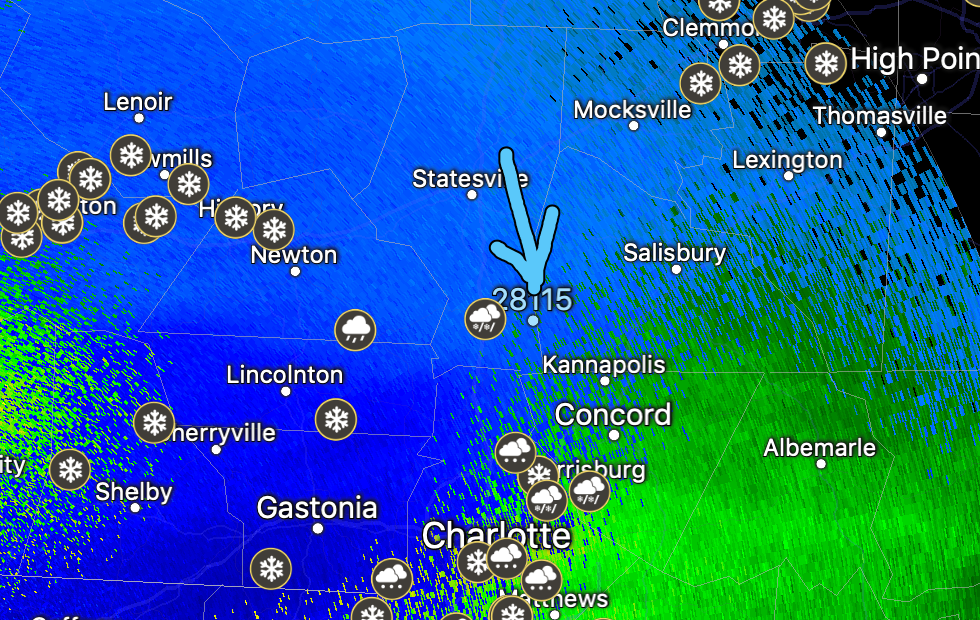
I am in Mooresville and there is no way we get to that 7-10 inches. It was snowing and is now flipping between snow and sleet. We will be lucky to get 2 or 3 unless something changes in a hurry.
-
2 minutes ago, Wow said:
With initial precip in Mooresville for the past 30 min, it's been sleet/snow as the sfc temps are crashing with this hvy band. It's whitened up the ground quickly. Expected to transition to all snow soon as the column is completely cooled. In fact, I hear less sleet and see bigger flakes mixing in now. This is going to be a big hit.
34.3/31
Any worry of the CC moving up our way? Seems like its racing north in a hurry.
-
2 minutes ago, Wow said:
Nothing downtown yet. lol... I know it's coming. This agonizing wait better keep the warm nose away later!
Same here. Near 115 and HWY 150.
-
1 minute ago, WxKnurd said:
Guys in Mooresville, it’s going to be a painstaking wait for you but it should be all snow there when it starts. It’s obvious this CAD is doing its thing with these dew points as radar returns have been the best all day over me north of 85 and the best I can do right now is a light snow/rain mix with the occasional bigger flake making it down. It’s wanting to start going to what everyone S and SW of here is seeing but not quite there yet. Sets up good for y’all when it finally breaks out up there.
I hope so. Hoping we can all score here. Agonizing right now.
-
1 minute ago, Freeze said:
Radar shows snow above Mooresville but its not reaching the ground.
If we can ever get it to reach we should be in great shape. We have to have a low dew point right now.
-
 1
1
-
-
5 minutes ago, Wow said:
why? this is per the forecast.
Not sure. Just my anxious self. Hoping this means drier air and more snow less sleet.
-
1
-
-
2 minutes ago, SnowNiner said:
Still dry in Mooresville. Precip has been stuck in clt for the last 2 hours. Can't get north.
Worrisome.
-
3 minutes ago, GunBlade said:
GSP updated maps very similar to last one.


I hope it happens but I'm still mostly dry up here in Mooresville.
-
3 minutes ago, SnowNiner said:
Where are you Wow in Mooresville? I'm 2 miles north of exit 36.
I near 115 and 150 in Mooresville. Just to add to that.
-
1
-
-
7 minutes ago, Poimen said:
That's not good right? If it's in Asheville it does not bode well for other areas, correct?
-
 1
1
-
-
3 minutes ago, Wow said:
I'd prefer a thin layer of sleet at first.. it's a good foundation for the mountain of snow.
")
We can always hope. Still hoping we can get a few inches of powder down at some point.
-
Still dry here in Mooresville. Eagerly waiting on my cold rain/sleet/zr.
-
Mooresville here. Not even raining at the moment.
-
2 minutes ago, kvegas-wx said:
Precip is smashing into a brick wall across TN and NC. Any thoughts on whether or not this may end up being our initial SN/IP battle line until later tomorrow as the warm nose starts to creep in? If so, that puts CLT squarely in the ice zone and the rest of the central and NW piedmont all snow for quite a while.
Pretty sure this was always the case. Very dry air at the NC/SC state line that will take a while to saturate. I still believe like always the battle line will be I-85 give or take 10 miles either way.
-
1 minute ago, PackWxMan said:

Coming into scope now... Sleet and Rain (both normal and freezing) the primary elements in CLT. Strong SWly jet going to be too much and will help erode CAD aloft.
Regardless that amount of sleet and ZR would worry me. If it busts just slightly with the ZR to rain ratio it would be some nice power outages there.
-
2 minutes ago, SnowNiner said:
Ok, so my official forecast from NWS for Mooresville is over a foot of snow. I'm not seeing it, but I hope it's right. Matches up with Allan and Eyewall, but I don't understand how the sleet storm after midmorning isn't going to cut those totals big time...
I think they are banking on the warm nose not being as strong. Others are saying it will be and cut into totals big time. Who knows maybe we get lucky up that way. I tend to think it will be somewhere in between with snow and then sleet/zr.
-
1
-
-
1 minute ago, UpstateSCBud said:
Not gonna happen, not that much anyway. Even half of that though in this area would be terrible.
Having lived through a terrible ice storm in 2004 just below Columbia, SC and seeing and hearing the popping sounds of acres of Pines being destroyed I would rather have cold rain than ice. Not to mention how long we were without power. No thanks.
-
1
-
-
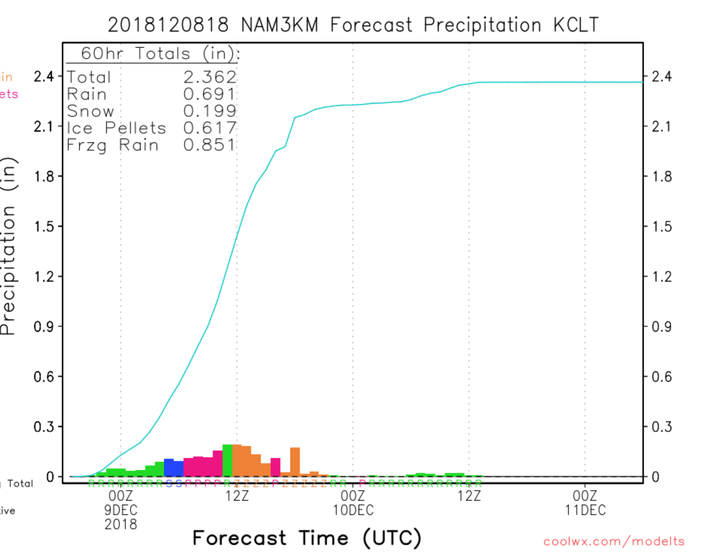
Just now, HurricaneTracker said:
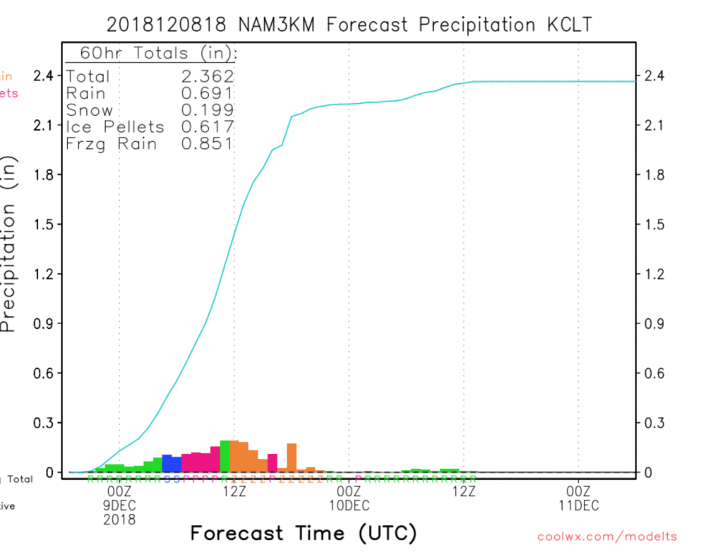
18Z NAM....who ordered up an ice storm?
Devastating if that verifies.
-
7 minutes ago, WidreMann said:
Are we sure they aren't as accurate?
Not sure, that's why I posed the question.
-
1 minute ago, WidreMann said:
18z NAM is coming in warmer and further north.
When do we start using much shorter range models like the HRRR, RAP and others? I thought lots of models like the NAM, GFS, Euro are not as accurate when you are literally inside 12 hours or less from go time?
-
4 minutes ago, WarmNose said:
If you follow a winter weather forum, there’s a 100% chance you are a snow weenie deep down inside. 100%. People show heartache in their own ways. They’re projecting. There’s a lot of bitterness built up for years and years of disappointment. Missing out on the “big one”. Insanity, really. Having lived where they live for most, if not all, of their lives and every year they somehow think things will be different. Time marches on.
Southern boy born and raised and not a young one at that now that I am older. I've been burned plenty by the warm nose and severely disappointed. It is just not really a way to go through life. It's miserable and has to suck. As much as people say that is only how they react to snow I am sure there is at least a small reflection of how that corresponds to how they are in daily life. That's all I am saying .
-
1
-


December 8-10 Winter Storm Obs
in Southeastern States
Posted
Sleet here in Mooresville.