

zippity
-
Posts
161 -
Joined
-
Last visited
Content Type
Profiles
Blogs
Forums
American Weather
Media Demo
Store
Gallery
Posts posted by zippity
-
-
4C here in Huntsville/Madison. Roads have been treacherous all week since all our precip came down as sleet, but today the roads are kinda sorta passable (those are meteorological terms, right?).
Our precip is forecasted to be rain, with the cold arriving quickly enough freeze the wet streets-wéve got a lot of wet, mushy ice that would be fine except that everything is supposed to freeze.
I'm very interested to see to the forecasts/models handle the existing snowpack in TN.
precip is currently virga.
-
 4
4
-
-
39 minutes ago, Uncle Nasty said:
We have absolutely nothing. We had light sleet and a quick changeover to light snow around 10:00pm. That lasted maybe 5 or 10 minutes. Everything missed us to the north and east. Local tv channels have backed wayyyy off. Anything from a dusting to 1 or 2". Local NBC just shows a mix icon. He said we would have a mix all day with temps in the mid 30's. I just don't see it happening here.
Sent from my SM-S916U using Tapatalk
Sorry to hear that.
-
HSV had reports of frozen precip last night; I am just very slightly west and there is nada-no frozen precip or snow. NWS Huntsville expects an uptick however:
By daybreak, expect things to get more active as vorticity advection
aids in the persistence of lift along a convergence zone spanning
from southeastern Arkansas to the Smokey Mountains.
Overall, little has changed regarding amounts. Still expect 2-5"
snow accumulations over north and western portions of the forecast
area, with lesser amounts and perhaps more in the way of sleet or
ice (up to 0.15") south and east of the TN River.
Great to see TN is doing so well. How is Chattanooga doing? Has any precip moved in?
-
1
-
-
Temperature in Huntsville 36F, dewpoint is 22.
-
3
-
-
4 minutes ago, John1122 said:
That seems early for that area but they will probably make a run at 5-7 inches.
I didn't believe it until I pulled up Foreflight weather.
-
2
-
-
Florence, AL is currently 33F with snow.
-
6
-
-
I think Winter Storm Watches will hit tomorrow evening from Florence toHuntsville and points northeast to SWVA and points north of there.
Thanks. Huntsville NWS is always conservative as we are so often on the very edge of any snowfall, but they did state that there was a 57% chance of snow greater than one inch. That's a pretty optimistic statement for them, imo.
-
3
-
-
 .
.
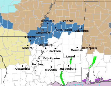
Winter Storm watch issued for parts of Mississippi. It's not Tennessee Valley, but imo still pertinent to size and scope of the developing system.
-
8
-
 2
2
-
-
On 1/6/2024 at 12:10 PM, John1122 said:
10 years ago we were getting a massive arctic express. 40-50 degree temperature drops.
That's when I joined this forum-That storm got me interested in meteorology.
-
5
-
-
Looks like I've picked a good week to login for the first time in a year....even if the storm doesn't pan out in my area, it's fun to watch us get giddy at the prospect of a big snow.
-
3
-
-
...and it's snowing in north Alabama! Roads are currently skating rinks, elevated portions closed and all that mess. Hope everyone gets home safe and warm tonight.
-
3
-
-
3” and -3 C. Fell asleep on top of my computer and missed it real time, dang it. I hope everyone got plenty of snow last night.
-
3
-
 2
2
-
-
7 minutes ago, Knoxtron said:
Showing about 7" at my house near Mghee Tyson. My wife and I live on a steep gravel road, about 1/2 mile long, with somewhat unforgiving asphalt roads around our house
We are having our first child Monday morning (via c-section)!!!!
You guys think roads would be an issue at all early Monday morning? Looks to be below freezing when we head to the hospital at 4AM.
I have plenty of salt and a leaf blower just in case haha I know it's overkill but you can't be to careful
Why don’t you go in now and get a hotel near the hospital
-
3
-
-
1 hour ago, AMZ8990 said:
If north alabama gets blasted with a huge snow again and I get nothing I’m gonna be furious. Lol
May this storm overperform for everyone! I’m amped to see how fast the temps change across the Tennesse Valley as it moves in-
-
1
-
-
North Alabama has just been added to the WSW: https://www.weather.gov/hun/
-
1
-
-
Few things are better than a classic Miller A in the springtime…
-
3
-
-
Well, well, well…wasn’t expecting that
-
1 C snowing most of the afternoon with no accumulation. Getting windy, temp is starting to drop.
-
1
-
-
Heavy snow, 3 C, Huntsville
Nice surprise, I thought the snow line was further away.
-
6
-
-
1 minute ago, Holston_River_Rambler said:
Just saw someone mention an ob of thunder near Huntsville on southerwx. It showed up on GOES derived flashes, and if that correlation coefficient above is right, someone in N AL just got thunder snow.
We have been getting thunder, but now snow yet.
-
1
-
-
- Huntsville checking in at 7 C and rain…
-
From NWS Huntsville: Ice Storm Warning issued for northwest and north central Alabama... https://www.weather.gov/hun/
21mFrom Twitter: Morgan County Sheriff's Office[Update] Major vehicle pile up. No major injuries. 231 blocked in both directions. Northbound is sheet of ice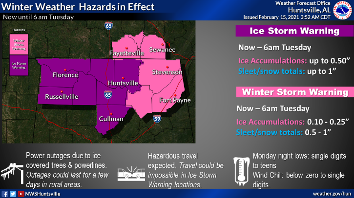
-
1
-
-
From NWS Huntsville via Twitter:
NWS Huntsville
@NWSHuntsville
Attn: Cullman, Morgan, Madison, Limestone, Lincoln, and Moore Counties: An area of freezing rain and sleet is developing and moving farther east than previously anticipated, and the HSV metro area may start to see ice accumulation in the next hour or two #StayPutStaySafe #HUNwx-
3
-
-
-1 C here in Madison, AL.
-
2
-
Fall/Winter Banter - Football, Basketball, Snowball?
in Tennessee Valley
Posted
Cicadas! Brood XIX, the Great Southern brood will be emerging this spring, most likely in April/May. Last time they emerged was 2011, not long after the April 27 tornado outbreak. We had so many cicadas in our neighborhood that they covered the houses and the sound was deafening.