

DFWWeather
-
Posts
427 -
Joined
-
Last visited
Content Type
Profiles
Blogs
Forums
American Weather
Media Demo
Store
Gallery
Posts posted by DFWWeather
-
-
2 hours ago, Quixotic1 said:
Denton is at 8 degrees. DFW is at 17. I don't think DFW will ever see single digits again.
DFW actually for sure hit 15°F, but may have hit 14°F. Waiting on confirmation on that. It is possible for DFW to hit single digits again, I can't explain the 21 year streak though. Statistics say this should happen every four years. Don't forget that we hit -1°F in December 1989 and statistics say we should fall below zero about every 30 years. We haven't seen an cold air mass of that magnitude since. Should it happen again, we definitely would hit the single digits. Had we gotten an inch of snow yesterday, I'm sure we would have fallen to the 10 to 12 degree range. Had we hit 11°F it would have been the coldest in 21 years.
UPDATE: The NWS confirmed the DFW Airport low this morning was 14°F, making for the coldest air since 2011. Also, we set a record low max yesterday of 27°F breaking the old record of 29°F set in 1970.
-
3 minutes ago, bubba hotep said:
Forecast high today was 26. Sitting at 21 with snow.
The forecast high today so far at DFW has been 27°F, so that was a good forecast. If this holds, which it will, then that means we set a record cold high as the old was 29°F set in 1970.
-
10 minutes ago, bubba hotep said:
Anyone getting flurries?
I can confirm snow flurries in Arlington and Hust.
-
5 hours ago, bubba hotep said:
Basically all models showing measurable snow for N. Texas except... The Euro. We've seen this battle before and seen the Euro win. Still, pretty tricky setup and we could see plenty of more shifts over the next couple of days.
24 minutes ago, aggiegeog said:I am liking this set-up for NE TX. Like always its a close call, but usually we do OK with developing Gulf lows. I have a feeling DFW may be too far west for much accum though with the cold air throughout the column there may be enough for and inch or two there. North of I-20 in NE TX I could see 1-3" with maybe a 4 or 5" amount in a sweet spot (best current guess would be around Marshall for that).
The 12z NAM looks dry to me other than some flurries. The ECMWF is just not on board. The problem with this is there is just no moisture. The 500mb pattern is not one that favors snow and ice here. If that little system tracking in from out west could deepen and draw up enough moisture...but unlikely given pattern, especially with Gulf low developing. Those always rob DFW of moisture and we need every bit to make this happen here.
-
38 minutes ago, vwgrrc said:
I thought the McFarland Signature was what contributes to the Dec 2013 dfw ice storm? But maybe I was wrong.
Full McFarland setups are associated with the storm track well to our south, severe cold, and freezing temps into the LRGV (as McFarland wrote about this pattern to be associated with the LRGV most devastating freezes, thus why it was given the name McFarland Signature). While snow and ice can still fall this far north in these setups, it is usually very light as we are so deep into the cold air that it becomes very dry, usually associated with 0°F isodrosotherm well to our south. Occassionally, large storm systems can time with the onslaught of cold air to produce heavier storms right after frontal passage. However, in this case the storm system is held back till Thursday well after the Arctic surge which would mean an unusually far south storm track and we would be well established in much drier air that it would have to fight at that time to get precip to the ground.
-
1 hour ago, bubba hotep said:
That is one of the things with this setup, the colder it gets the more suppressed it looks.
Strongly agree...and in this case the colder drier solution looks correct imho. Given the amount of Arctic air that will be flowing down from the north, flow coming almost due north from the Arctic circle, the deeper, colder solution the ECMWF has looks correct. This is a McFarland setup. Folks, this is not a favorable upper air pattern for big DFW winter storm. The op GFS looks like an outlier to me and doesn't agree with the majority of its ensemble members. If anything, further south would be a target for frozen precipitation. I would not be surprised for freezing temps getting into LRGV with this setup.
The EPO going postive allowing for mid month warmup looks in error as the long wave global synoptic pattern says that should stay negative. AO, NAO, WPO, PNA, EPO (arguably) remaining negative points to widespread CONUS cold (save for Florida). Climate Prediction Center is in agreement as well with cold lasting well into week 2 of January. Joe Bastardi explains this today in his morning video. With Greenland blocking this cold is going to be in no hurry to leave with more building up behind it.
-
If 12z ECMWF pans out for next week...we would be talking severe cold into Texas with freezing temps into the LRGV. With -15°C air sitting over DFW, it would produce surface temps in the single digits for the first time in over 20 years. This still may be obtainable with the GFS solution if we get snow and ice on the ground. This cold with Greenland block may hang around for a while with more into week 2 of January.
-
21 hours ago, bubba hotep said:
The 12z GFS today is an even more classic look, too bad it is way out in fantasy land.

0z today is as wickedly cold. It has nearly -15°C air sitting on top of DFW with surface temps in the single digits with highs only in the upper teens to around 20 for the first week of January. La La Land....ECMWF has nothing at all. However, EPO, WPO are projected to go strongly negative. The PNA looks to also be in the negative territory (which isn't a great signal for us down south). It does appear that the pattern that brought us cold in early December may try to come again with ridging into Alaska. This may be a colder version of that pattern though.
-
45 minutes ago, bubba hotep said:
12z GFS is close to keeping the northern DFW burbs below freezing until Tuesday. But other than that things look pretty blah until maybe a system Christmas weekend.
GFS MOS Guidance for both 0z and 12z down to 13°F with a dewpoint of -1°F. Also 0z has us in the teens Sunday, Monday, and Tuesday mornings. Pretty impressive cold shot! We still need to break the 21 year streak of not getting to the single digits. Truly impressive when statistics say that should occur 1 out of every 4 years, maybe 5 now with that streak.
-
1 hour ago, bubba hotep said:
12z GFS was disappointing for the DFW area but about 1/2 of the GEFS members show something frozen over the weekend.
It wasn't disappointing for the 26th. Has major winter storm then. It does however continue the trend of being colder with this outbreak for DFW for Sunday through Tuesday. From what I can gather from the NAM, just barely coming into range, it also appears colder at the surface and at H85. I'm going with a low of 18°F for Monday morning at DFW Airport and maybe not getting out of the 20s all day on Sunday. It is even conceivable that we will struggle to get above freezing, if at all, on Monday as well. Those hoping for snow with this blast, I'm afraid are out of luck. Best we can do is some freezing drizzle possibly or light flurries, but the surface is looking drier and the moisture to scour out quicker before subfreezing temperatures set in. Not real excited yet regarding storm system FWD is looking at for next week, where they mention possible wintry precip. Time will tell!
-
8 minutes ago, ams30721us said:
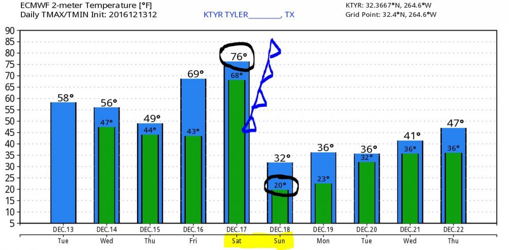
Wow! This reminds me a TON of March 2014 here. The night of the big Ice storm behind the arctic front. Not saying we will see that again, but that day we had temps in the 70's before the front rolled thru and we dropped into the low 20s here by morning. This front may even be stronger than that one since back then we actually had 3 inches of sleet and freezing rain everywhere. What a wild drop! 76-20 in 12 hrs!
Oh and temp Tuesday are def. not balmy with that next system hovering around or just above freezing on Tuesday.
In the 80s when these massive Arctic fronts came barreling through, I've seen the temperature drop 40+ degrees in 1 hour at DFW before. In Amarillo, when the December 1989 front came through the temperatures dropped 50+ degrees in less the 20 minutes causing light to bend. There were tons of reports people seeing mirages of cows in the sky because the light was bending. Texas extreme temps swings not uncommon!
-
1 hour ago, bubba hotep said:
12z Euro keeps DFW below 30 for the high on Sunday, unless it is above 30 after midnight. It is hard to tell exactly when DFW goes below 30 since it goes from 71 at 00z to 24 at 06z. Also, it kicks out the low and is much wetter than past runs but looks too warm for any winter weather.
Just gonna post this exact same thing. It also keeps us in the 20s all day Monday as well looks like after a low of 17°F Monday morning. I'm afraid the wintry precipitation with this front doesn't look all that exciting. Can't rule out flurries or freezing drizzle yet, but nothing significant. This definitely looks colder than last week and the coldest since January 2015 on lows, probably longer on highs.
-
The models this morning are not our friend. The Arctic front this week will ooze south against the means, but the core of the cold looks to go north and east of Texas. Basically, here it is just a regular cold front. The Arctic front by the 18th looks a little more promising, but all the operational models have backed off on the amount of cold air. The GFS noses the Arctic air to about Lubbock and then retreats it back north. When has that ever happened? Only the CMC 500mb mean looks to support cold air into Texas, the GFS and ECMWF are building the southeast ridge really strong keeping trough in the west. I mean huh? Looking beyond the 18th, the ECMWF on both the operational and EPS has no more Arctic air at all through the end of the month. Must be a product of the EPO and NAO forecast to trend positive. WPO is looking to stay neutral to negative. What a complete mess!
-
12z Model suite have 500mb pattern not conducive for Texas penetration of Arctic air next week. All three, CMC, GFS, and ECMWF show stronger ridging and push the coldest air across the Great Lakes out into Atlantic. I have only looked at 12z GFS operational and it follows with eastern push of cold air.
-
A full continental trough next week with air -30°C + sinking south, probably originating in Siberia. 1983, 1989 anybody? Though I must admit none of the operational models really bring it deep into Texas, at least not yet. 500mb ensemble means of the CMC, GFS, ECMWF look wicked though!
-
Looks like the KDFW AFD from NWS this afternoon is still biting hard on the cold air with and even suggesting the possibility that DFW will fall below 20°F Friday morning. This has been more along my lines of thinking from the get go with this air mass. However, with the ECMWF coming in so much warmer today, not sure that can happen. Even if it does fall to at least 21°F or colder, it will be the coldest morning at DFW Airport since January 8, 2015. We actually reached 22°F in March 2015. Regardless, as long as we dip below 27°F, which I'm reasonably confident we should, it will be colder than all of last winter. Thursday should do the trick as well which keeps us below 40°F during the day, which we never did last winter.
-
2 hours ago, aggiegeog said:
Man this month is setting up to be brutally cold. I would not be surprised to see us reach the single digits for the first time in 20 years and maybe challenge 83 and 89 if a good -EPO sets up.
12 minutes ago, Quixotic1 said:I'm traveling so can't see. What are the Euro and GFS saying?
The 0z GFS today had a very nice shot of Arctic air in the extended, however all runs after nothing. Operational ECMWF looks warmer across the board today...both runs. 12z ECMWF has a some Arctic air trying to nose down at 240h, but its H5 pattern won't allow it to get here.
-
6 hours ago, bubba hotep said:
FWD sounding pretty bullish on the cold and going for 20 at FWD:
Winds will lessen Thursday night and Friday morning as surface
high pressure becomes centered over southern OK. Light north winds
will be in place, and with clear skies and very dry surface air
(dewpoints in the low teens), favorable radiational cooling should
cause temperatures to plummet. Have drastically undercut guidance
once again on Friday morning with my only fear being that I didn`t
go cold enough. Current forecast lows at DFW and Waco are around
20 degrees which would be the coldest temps since January 2015.
Yeah, they are, but the ECMWF has really backed off on the cold air today. Thinking maybe lows 23°F-25°F look more reasonable based on that, maybe even warmer. NAM is just coming into the picture. Basically what the GFS has been saying all along.
-
The 12z GFS vs 0z ECMWF are very different on next week. GFS is warmer than ECMWF and has been the whole time. Shouldn't this be the other way around? GFS has a more NW SE trajectory sending the coldest air off to our north and east giving just kinda a glancing blow.
-
This Arctic front looks as though it will penetrate all the way to Central America!
-
WOW! Today's 0z ECMWF has H85 temps down to a whopping -14.5°C at DFW after Arctic front next week. Last time we saw H85 temps anywhere near this cold was during the intense Arctic air outbreak the week of the Super Bowl in February 2011. The NWS this morning said they undercut the coldest guidance on Thursday's temps with a low of 28°F and high of 44°F. They must have not looked at the ECMWF. This kind of cold would produce nearly the coldest temps at DFW in nearly 20 years comparable to 2011 but more like February 1996, but colder. Outlying areas would see lows in the single digits with the Airport itself between 10°F and 13°F. Highs would not get above freezing Thursday. If we had a snow pack with that kind of cold then single digits even at the Airport would be a good bet. However, the ECMWF is bone dry.
-
8 minutes ago, aggiegeog said:
That would not be surprising. The GFS is way too progressive with this system while the Euro is slower but colder. It is very cold in Canada so the GFS idea of only getting as cold as we were this morning without the support of a very cold Arctic seems unreasonable. Thursday morning looks to be very cold (single digit and teens windchills) as there will likely still be some wind, Friday morning will likely see the coldest air temperatures (I expect rural areas to make a run at the teens). These temperatures could be moderated if we end up with any shortwaves in the cold air, but we will happily trade a hard freeze for snow.
12z ECMWF came in colder back to the -9°C. If that holds, I wouldn't be surprised (presuming excellent radiational cooling setup) if DFW Airport doesn't make a run for the upper teens. The ECMWF is bone dry.
-
1 hour ago, aggiegeog said:
It looks to me like the 12Z GFS shows flurries behind the front Wed morning. Even if this is not exactly the solution still being almost a week out the idea is on the table for at least some kind of pulse or maybe multiple NW flow pulses within the Arctic air mass. These are almost impossible to nail down until right before they come through though in the past we have had some good snow out of these with little warning.
The 12z GFS is significantly warmer then ECMWF, both at the surface and at H85, with this cold blast due to the weaker upper low. The ECMWF and CMC are colder. Will this be colder than anything we saw last year at DFW? Coldest low was 27°F last year. I'm thinking right now we could be 23°F to 25°F at the coldest at DFW Airport. What maybe even more interesting is the intense cold coming after this where the ECMWF has nearly -40°C air entering the CONUS. Where that goes will be interesting?
-
Today's 0z models, especially ECMWF, have come in quite a bit warmer for potential Arctic air next week. The H85 temps have warmed to -4°C for DFW with the brunt of the arctic air shunted east across the north. The 12z GFS even warmer.
Shockingly the yo-yo ride continues with the 12z ECMWF back on board to significant Arctic air with H85 temps back down to -8.3°C for DFW.

Texas/New Mexico/Louisiana/Mexico Obs And Discussion Thread Part 8
in Central/Western States
Posted
That eastern ridge looks too strong. If we can get that Arctic high underneath the ridge...all bets are off. The ECMWF is known to be too slow in that time range on Arctic air, and doesn't model well the cold air damming process which is clearly evident on the 0z run.