

joc111
-
Posts
105 -
Joined
-
Last visited
Content Type
Profiles
Blogs
Forums
American Weather
Media Demo
Store
Gallery
Posts posted by joc111
-
-
-
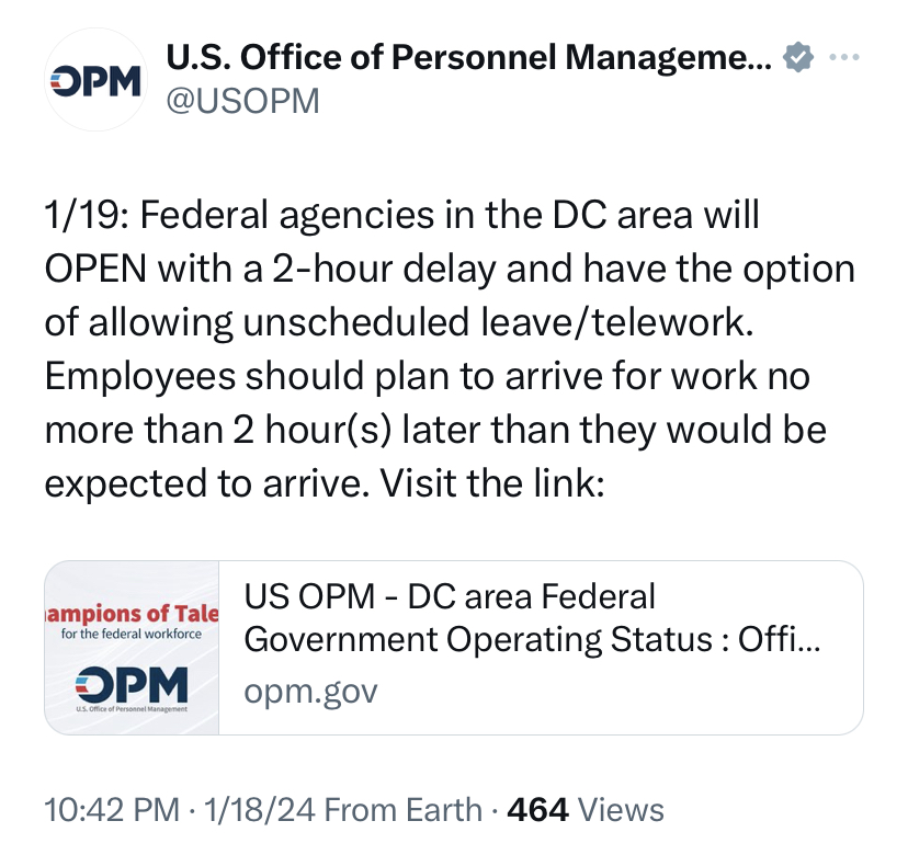
Fedcasting that OPM orders max telework tomorrow due to anticipated conditions during the morning commute period.
-
5 minutes ago, Maestrobjwa said:
Don't you mean the Kuchera thickens?

when the kuchera thicc

-
 2
2
-
-
-
3.2" storm total thus far in Reston near Tall Oaks.
-
 1
1
-
-
Live from L'Enfant...
31.8/30.5 -SN
Last of the snow showers is pulling on out. Received about 3.5". City streets are wet.
Signing off for this storm!
-
Live from L'Enfant...
32.2/30.9 SN
Untreated paved surfaces have crashed and are coated.
-
Live from L'Enfant...
33.3/27.7 SN
Hard surfaces still just wet. Snow has transitioned from a graupel texture to regular flakes.
-
1
-
-
Live from L'Enfant...
35.1/25.7 SN
Snow has a bit of a graupel feel to it. Nice little easterly breeze, too.
-
Final SPOTREP for the overnight until my alarm at 3pm...
33.1/32.6, dialed back from +SN to SN for the moment with accumulations continuing on cars and grassy surfaces 12 stories below, and I'm looking forward to waking up this afternoon to a winter wonderland.
Good night, and good snow!
-
3 minutes ago, yoda said:
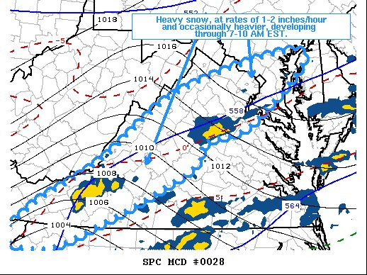
   Mesoscale Discussion 0028
   NWS Storm Prediction Center Norman OK
   0413 AM CST Mon Jan 03 2022

   Areas affected...Parts of southwest through northern Virginia and
   central Maryland

   Concerning...Heavy snow

   Valid 031013Z - 031415Z

   SUMMARY...Heavy snow rates around 1-2 inches per hour and
   occasionally greater appear increasingly possible along and to the
   east of the Virginia Blue Ridge Mountains, into the Greater
   Washington D.C. and Baltimore Metropolitan areas, through 7-10 AM
   EST.

   DISCUSSION...Precipitation rates have increased along a frontal zone
   north through north-northeast of a deepening surface cyclone center
   across the South Carolina Piedmont.  Although temperatures near the
   surface and in layers aloft are generally still warm to the east of
   the Appalachians, across much of the southern Mid Atlantic, a
   combination of strengthening mid/upper forcing for ascent and
   gradual low-level cold advection on northerly surface flow is likely
   to contribute to profiles increasingly conducive to snow.

   Surface temperatures are already approaching freezing across much of
   the Greater Baltimore and Washington D.C. metro areas into the
   immediate lee of the Blue Ridge, where strengthening mid-level
   frontogenetic forcing for ascent appears likely to become focused,
   beneath an intensifying divergent flow field between coupled upper
   jets.  Forecast soundings suggest that lift will become increasingly
   maximized within the dendritic growth layer through 12-15Z, in the
   presence of seasonably high moisture content (including precipitable
   water on the order of .75-1.0 inches) supportive of 1-2 inch per
   hour snow rates, and perhaps occasionally heavier.

   ..Kerr.. 01/03/2022

   ...Please see www.spc.noaa.gov for graphic product...

   ATTN...WFO...PHI...AKQ...LWX...RNK...MRX...
I love it when SPC talks nerdy to me.

-
1
-
-
-
First signs of clear accumulation on grassy surfaces. Still +SN.
33.6/32.1
-
1
-
-
Bordering on +SN based on downtown landmarks...
33.6/32.1
-
2
-
-
1 minute ago, EHoffman said:
It's white rain. Not sticking anywhere
It is on parked cars. Grass and roads will be soon enough.
-
33.8/32.3 SN
Visibility now well under a mile based on downtown landmarks.
-
1
-
-
-
34.7/32.9
Temperatures continuing to crash and visibility is well under 1.5 miles, as the Washington Monument – or even its lighting scheme – is no longer visible from my vantage point.
-
We're crashing as the transition has taken hold...
35.4/33.3
-
Finally, definitive evidence of flakes in NoMA...
36.3/34.2
-
1 minute ago, snjókoma said:
08z HRRR shifts the axis of heaviest precipitation a bit southeast.

-
 1
1
-
-
Getting hard to decipher with the darkness, but it appears to still be all rain in NoMA... 36.7/34.3 at the moment.
-
39.2/35.4 in NoMA
All rain as the first truck heads down North Capitol with the plow down.
-
1
-
-
ALL of the kids (and kids at heart) sledding down Capitol Hill tomorrow.

-
1
-

Jan 19th Storm OBS Thread
in Mid Atlantic
Posted
Ripping in Reston.
4.5" of new snow as of 11am.