
Not me in VT
-
Posts
76 -
Joined
-
Last visited
Content Type
Profiles
Blogs
Forums
American Weather
Media Demo
Store
Gallery
Posts posted by Not me in VT
-
-
As always, any Generator Questions/electrical Question shoot me a message.
-
 5
5
-
-
47 minutes ago, Hoth said:
Sadly I'm not qualified to answer your question. Just chiming in to ask what storm that is in your avatar.
96 hours leading up to the Groundhog Day 2015
-
 1
1
-
-
The Irene comparisons I seeing; Even a chance of verifying? Do I pull my crews working in The Mount Snow region? Thanks guys and you all rock! Even Kev lol.
-
3
-
1
-
-
1 minute ago, wx_observer said:
didn’t realize the winds were expected to be this high this far inland.  That, plus 12-18” sounds like generator territory.

URGENT - WINTER WEATHER MESSAGE
National Weather Service Boston/Norton MA
335 PM EDT Sun Mar 12 2023

MAZ002>004-008-009-026-130845-
/O.UPG.KBOX.WS.A.0005.230314T0000Z-230315T1200Z/
/O.NEW.KBOX.WS.W.0004.230314T0000Z-230315T1200Z/
Western Franklin MA-Eastern Franklin MA-Northern Worcester MA-
Western Hampshire MA-Western Hampden MA-Northern Middlesex MA-
Including the cities of Charlemont, Greenfield, Orange, Barre,
Fitchburg, Chesterfield, Blandford, and Ayer
335 PM EDT Sun Mar 12 2023

...WINTER STORM WARNING IN EFFECT FROM 8 PM MONDAY TO 8 AM EDT
WEDNESDAY...

* WHAT...Heavy wet snow expected. Total snow accumulations of 12
  to 18 inches. Winds gusting as high as 55 mph.

* WHERE...the high terrain of western and central Massachusetts.

* WHEN...From 8 PM Monday to 8 AM EDT Wednesday.

* IMPACTS...Travel could be very difficult to impossible, with
  snow covered roads and near zero visibility at times. Gusty
  winds could bring down tree branches.

* ADDITIONAL DETAILS...heavy wet snow combined with gusty winds
  will increase the risk for power outages. This will be a high
  impactful winter storm.

PRECAUTIONARY/PREPAREDNESS ACTIONS...

If you must travel, keep an extra flashlight, food, and water in
your vehicle in case of an emergency.
Any one with Generator questions shoot me a message.
-
2
-
-
Just now, JC-CT said:
Is the concern really just with the outlet?
No, The electronics and the ignition coil would be the concern.
-
1
-
-
4 hours ago, SJonesWX said:
portable generator, does it need to be covered when outside?
It's helpful but not required unless you have extreme driving rain and wind.
-
4 hours ago, JC-CT said:
Can you come to my house and install a switch for me? Follow up question, when will you be here?
I'll be right over, what's for dinner?
-
1
-
-
Good morning all, generator technician and master electrician here. Any questions I can help.
-
2
-
2
-
-
Overdone?

-
2
-
-
Anyone here have Generator ?s /problem, feel free to DM. Might be a busy night.
-
1
-
-
Does anybody know if the IBM or a similar power outage models are available to the public?
-
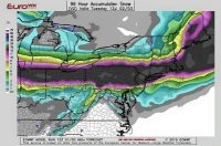
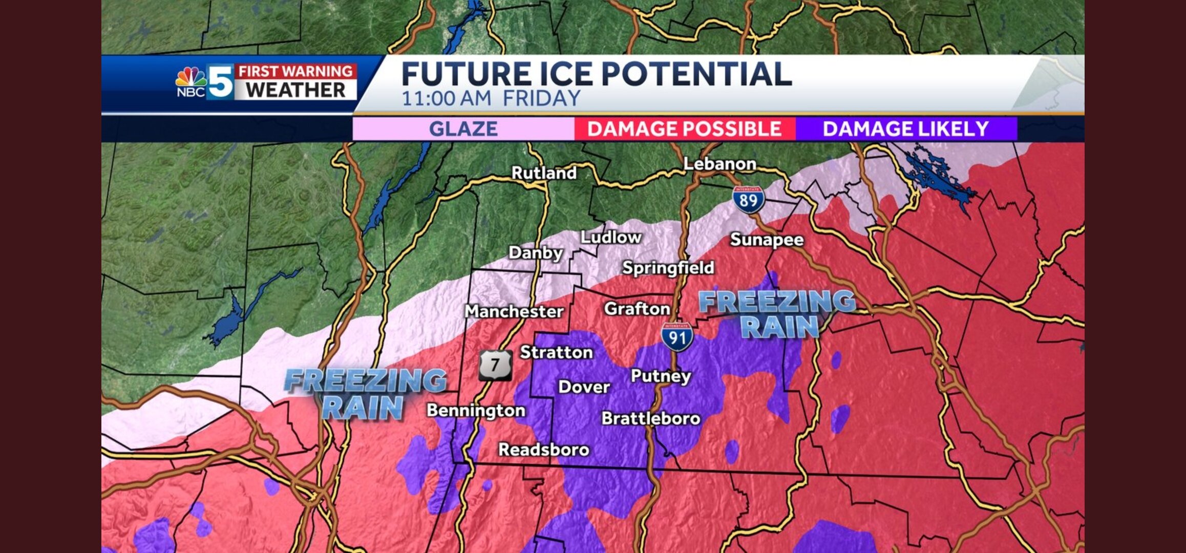
SVT ice? I'm thinking more of sleet for the West River valley. Overdone like usual or it's a real ZR signal this time.
-
Not really sure where to start, also not sure what I was just reading. Perhaps some type of doctoral study or professional counseling services? This thread is gold! Dying over here. Ribs hurt.
-
1
-
 2
2
-
-
1 hour ago, HoarfrostHubb said:
Pivotal ice

Guess my generator business would be in "trouble". SVT looks prime on this run, we all know what happens this far out.
-
13 minutes ago, LongBeachSurfFreak said:
Light snow has started here west Townsend SVT 1000’ expecting 18” here.
5 miles up the road from me. Small world.
-
6 minutes ago, Ginx snewx said:
Man signal in Berks for some hellacious snow rates has improved all day.
I think we should do okay here in the southern greens even in the West River Valley..
-
00z GFS could be worse for SVT, I see some power issues, why do I feel like the last guy to go to sleep at a house party or who's sober when posting in here tonight, lol
-
1 hour ago, moneypitmike said:
Perhaps, but I'd drive to Camden rather than Brattleboro.
Come on up this way! Had to Brattleboro and head up route 30.
-
18 minutes ago, backedgeapproaching said:
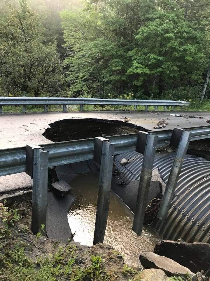
I think most of those DEC 20 40+" reports were just ruler in the ground reports, there really wasn't enough time for any clearing, it was all in like 9-10 hours. One clear would have been the max, if it was even done. Im not sure how much the total would have increased from that one clear anyway--maybe in the absolute max spot could have been near uppper 40s to 50". No one had 50"+ on the ground, but pretty damn close. There are pics of 42-44" OTG. I measured 33-34" OTG a full 30 hours after it stopped in that prime zone just north of me, obviously it was pure fluff so it was settling quickly, showing it was certainly 40"+ OTG the day prior, but 50" probably a stretch.
Ludlow Vermont had 40", across from you here in Townshend we had 30"
-
Here in SVT growing quite interested in the ice potential.
-
2
-
-
Just now, 40/70 Benchmark said:
No need to sit in the dark corner and watch....come on out and play!
Will do!
-
12 years lurking in here, feel like I know all the major players, hahaha, are we going to run out of time with this west/more amped trend?
-
1
-
-
Here is SVT they fly in your eyes, up your nose and under your clothing as of late. July's 18" here helped hatch upland mosquito eggs which can lay dormant for 7 years.
-
2
-
 1
1
-
-
16" in Townshend VT for July, 3.5 of which fell last night in a short time.

-
1
-
1
-

1/13/24 Sultan Slicer #2 - Heavy rain, snow, wind?
in New England
Posted
Type n mortar followed by closed cell spray foam, $$$ or Plastic water membrane with French drain below. Lastly, spray Shotcrete. Good luck