

gtg947h
-
Posts
176 -
Joined
-
Last visited
Content Type
Profiles
Blogs
Forums
American Weather
Media Demo
Store
Gallery
Posts posted by gtg947h
-
-
1 minute ago, GaWx said:
You picked the perfect time to live on the coast as Jan of 2018 was the biggest SE coastal winter storm since Dec of 1989 for many!
Here, there was ~0.5” of ZR (probably the most in one storm in nearly 100 years…it stopped just before widespread outages were about to start) and 2” of a combo of sleet and snow. A good portion of that 2” hung on in shady areas for 4 days, a very rare feat! There being sleet in it combined with it being several degrees below freezing during most of the storm and very cold to follow allowed it to stick around for so long.Yep, distinctly remember that one (though my son doesn't; he was 22mo). The next day we drove to Atlanta for wife's first brain surgery and observation... and it proceeded to snow again (up there) the night before we came home! I think we used up our quota for the decade...
-
 1
1
-
-
6 hours ago, GaWx said:
I'm thankful but also amazed at the comparison.
Any thoughts from anyone about this comparison?
I'm trying to remember Hermine... I think we got tornado warnings for that one too, but overnight. I can't recall how strong it seemed but I do vaguely remember it just being longer with more rain and wind.
The buildup to Idalia definitely seemed more dire--after all we expected a full Cat 1 to pass right over my house (the track kept jumping to either side of us). At least out here it was almost a non-event--just a couple trash cans and basketball goals tipped over and some small twigs and pine needles on the ground. Our power never even flickered.
But yeah, very interesting observations!
-
1
-
-
Downgraded to a tropical storm now (1700 EDT advisory)
-
 1
1
-
-
2 hours ago, GaWx said:
Compared to the 5AM NHC forecast, it has weakened quite a bit more quickly than forecasted then. The 5AM had Idalia still with winds of 100 mph as of 2PM. But as of 1PM, winds were already down to 80.
The 11AM had adjusted for this quicker weakening because it was already down to 90 then. This updated forecast had it weakening from 90 at 11AM to 75 at 8PM. But with it already down to 80 at 1PM, it appears that it is weakening even more quickly than the 11AM NHC forecast.
Let's hope that trend continues....
-
1
-
-
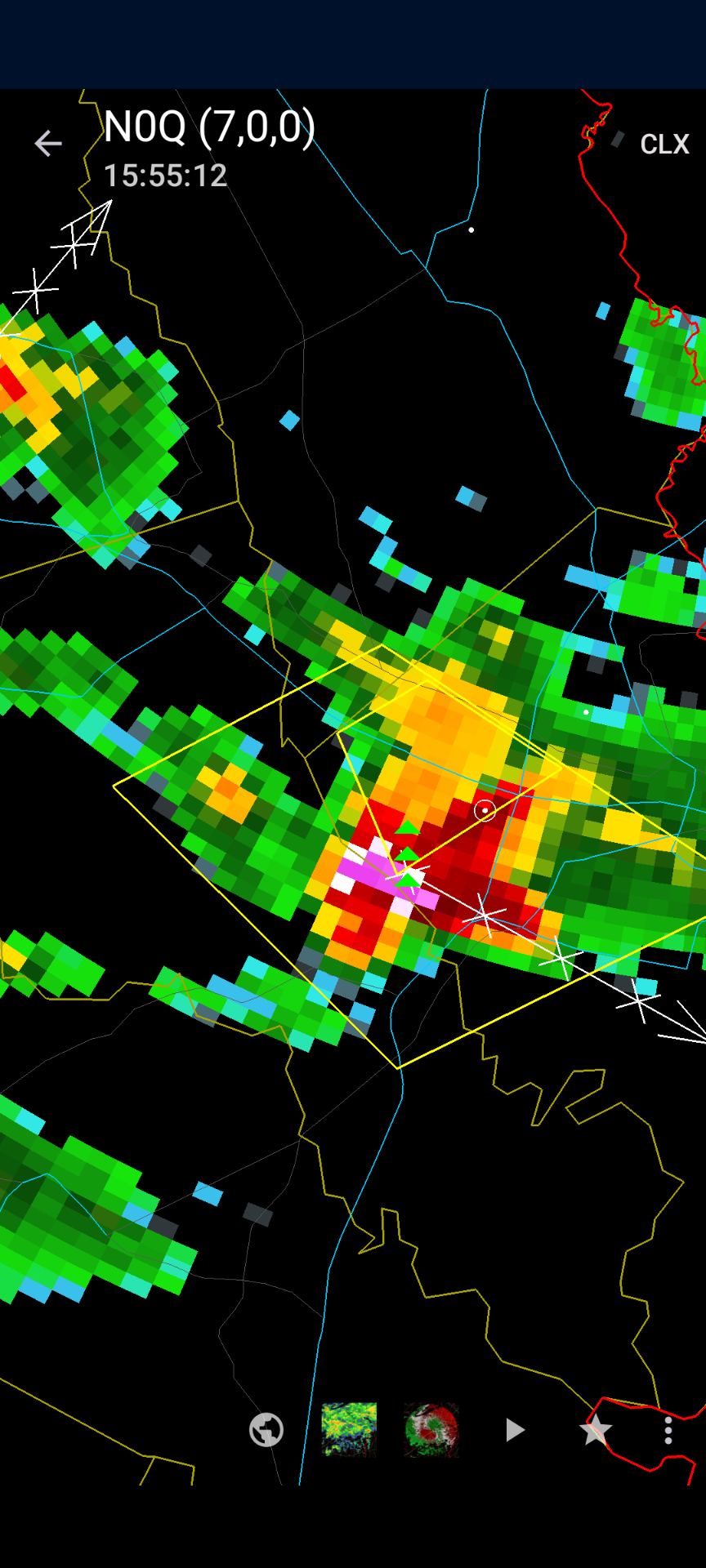
Tornado warning southwest of Savannah, and I'm right on the edge...
-
I deove through the last wave heading west from downtown Savannah last night. Really heavy rain and some intense lightning for a bit. And too many people driving with hazard lights on...
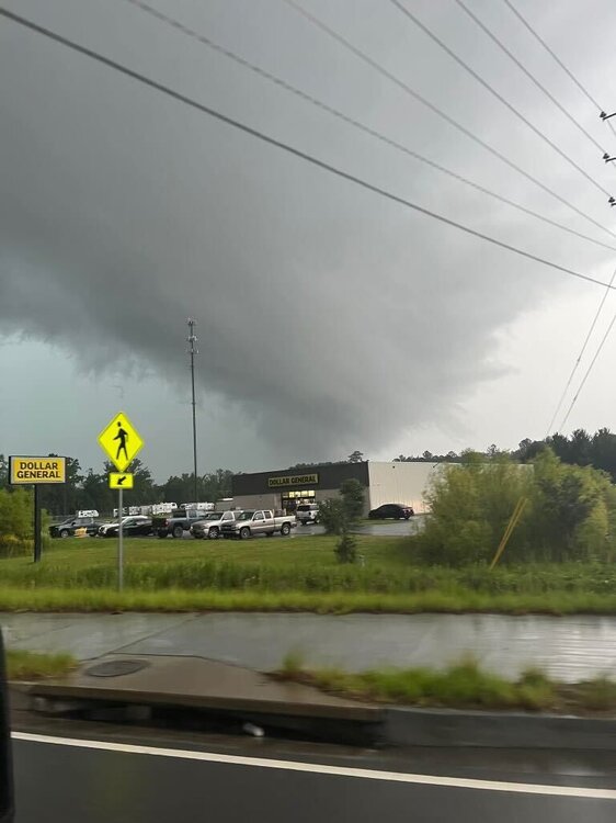
A friend took this picture of the tornado-warned storm in Effingham.
-
2
-
1
-
-
Dang, we got hail again! Just pea sized this time but still... Three times in less than two months. We almost never get hail here.
And it's still raining, and our backyard is flooded...
-
Got a little bit of ~3/8" hail last night... it's a little weird getting hail twice in a couple months, since we rarely see it at all.
-
2 hours ago, GaWx said:
near the normal daily high for mid-winter!
Yeah, yesterday and the night before had a winter feel to them, and given time of year and recent warmer weather they even felt a little colder. It was remarkable, but honestly kinda miserable especially for the first week of summer vacation...
-
2
-
-
We had a pretty good storm today with 1/4in hail (and apparently bigger at my son's school--he came home saying "it was raining ice cubes!"
 )
)
But just to the south/southwest they got some nasty hail, and I haven't seen that much purple and white on a radar in a long time, if ever. It got worse after this picture...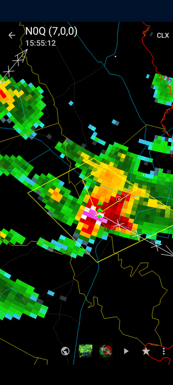
-
1
-
-
19 hours ago, GaWx said:
Are there more frosts and even freezes on the way for much of the SE within the first 10 or so days of April?
Ugh... the neighborhood pool opens 4/1 and I was hoping to make use of it...
-
32 minutes ago, IowaStorm05 said:
I’d like to complain about the change from 80s turned into 60s for daytime highs in Florida during this pattern. We’re having to use the heater again and it’s uncomfortably cool for my taste. We don’t get snow, so there’s no reason to champion chilly patterns here. It’s just uncomfortable and it’s unlikely many people on this sub are going to get real snow out of this.
We had like 2 weeks of 80s up until this week and I had been mistaken that we were home free from using the heater anymore
Agreed. I had to break out the winter workout clothing again

-
7 hours ago, GaWx said:
The 0Z GFS has a hard freeze in many inland areas and a light freeze all of the way to the SE coast and down to the FL/GA border on March 20th. Sone of these would be near record lows. This is the coldest night of the entire run.
I guess the one bright spot would be, maybe it would kill off some of these danged gnats...? I got eaten alive at my son's soccer practices this week...
-
1
-
-
It's absolutely glorious here, 84F at KSAV with a nice breeze and low humidity. I'll take two months of this, please...
-
It was absolutely beautiful outside today. Sunny and warm without a cloud in the sky most of the day. Unfortunately I had to work so I couldn't fully enjoy it

-
PDS tornado watch for LA and MS...
https://www.spc.noaa.gov/products/watch/ww0572.html
QuoteURGENT - IMMEDIATE BROADCAST REQUESTED Tornado Watch Number 572 NWS Storm Prediction Center Norman OK 1210 PM CST Tue Nov 29 2022 The NWS Storm Prediction Center has issued a * Tornado Watch for portions of Southeast Arkansas Northern and Central Louisiana Central Mississippi * Effective this Tuesday afternoon and evening from 1210 PM until 700 PM CST. ...THIS IS A PARTICULARLY DANGEROUS SITUATION... * Primary threats include... Numerous tornadoes expected with a few intense tornadoes likely Scattered large hail and isolated very large hail events to 2 inches in diameter likely Scattered damaging wind gusts to 70 mph likely SUMMARY...Supercells are expected to develop this afternoon and track northeastward across much of northeast Louisiana and central Mississippi. Parameters appear favorable for strong and long-tracked tornadoes this afternoon and early evening. The tornado watch area is approximately along and 80 statute miles north and south of a line from 25 miles north of Fort Polk LA to 55 miles south of Tupelo MS. For a complete depiction of the watch see the associated watch outline update (WOUS64 KWNS WOU2). PRECAUTIONARY/PREPAREDNESS ACTIONS... REMEMBER...A Tornado Watch means conditions are favorable for tornadoes and severe thunderstorms in and close to the watch area. Persons in these areas should be on the lookout for threatening weather conditions and listen for later statements and possible warnings. && AVIATION...Tornadoes and a few severe thunderstorms with hail surface and aloft to 2 inches. Extreme turbulence and surface wind gusts to 60 knots. A few cumulonimbi with maximum tops to 500. Mean storm motion vector 24035. ...Hart -
Latest NHC track nudged a tiny bit further east with a landfall on Edisto. Out of pure self-interest I continue to wish it further east...
Schools here are closed today and tomorrow, citing among other things "high winds... that will create dangerous conditions for the operation of school buses... and unsafe conditions for our walking students". My six year old is devastated. "But Daddy, I want to go to schoooooooool!!
 "
"
-
6 hours ago, GaWx said:
It is really amazing how much wetter this portion of the county has been in comparison to the western portion this summer!
And it's been pretty wet out here in the western half, at least in the last few weeks. If y'all have been getting so much more...
The two feet of water along the back fence finally drained on Wednesday. Was expecting it to come back but it hasn't rained hard out here so far today. Getting sick of clouds and rain and ready for some cooler fall days...
-
10 hours ago, GaWx said:
No rain the last 3 days. But today was pretty unique with what is Saharan Air Layer dust, which barely made it up here. The skies were milky and the sun was filtered along with PC skies. It had the look of smoke or thick summer haze. Interesting stuff!
....
Update at 8:10 PM: A strong outflow boundary has just arrived here around sunset from thunderstorms to the west making it suddenly quite windy. We have a shelf cloud of sorts overhead. Will we get rain from this? The radar for now shows only the dry outflow boundary.
Stepped outside of work to go home and saw the haze. First thought was that they must have been doing another burn at Ft. Stewart... now I know what it was!
Caught the eastern edge of that storm, good bit of wind and a little rain. Cooled things off nicely for a bit.
-
1
-
-
Now if only we could get some rain... but I gotta admit that the lower humidity has been welcome, too.
-
20 hours ago, GaWx said:
Welcome to summertime thunderstorms in the south!
I've lived in Georgia for 31 years, I'm used to it

Doesn't make it any less disappointing though...
-
I swear, those two heavier precip areas split right around my house and passed by either side. We had thunder all afternoon with nothing but a brief shower, then this leaves us out of most of the fun...
-
 1
1
-
-
On 4/5/2022 at 7:29 PM, Iceresistance said:
He's crazy!
One of my friends knows the guy (and it's in the Twitter thread too)... he had been golfing and couldn't get in the clubhouse because it was locked.
I was just out in Pembroke today with some friends helping clear trees from yards. We weren't working in the heaviest hit areas but more right around the start of the track, a block or two west of the courthouse. Even in the areas we went, there was considerable damage. No photos to add unless y'all just want to see some dudes carrying tree limbs and such.
-
It's not over yet... another Enhanced area for today covering most of Georgia, Alabama, and eastern Tennessee

April 2024 obs
in Southeastern States
Posted
We stole all your rain... our gauge said 4.36 when it was all said and done. And the back yard is flooded...