
CoolBreeze
-
Posts
235 -
Joined
-
Last visited
Content Type
Profiles
Blogs
Forums
American Weather
Media Demo
Store
Gallery
Posts posted by CoolBreeze
-
-
Still getting flurries, even though the radar shows nothing here.
-
Light snow falling here wtih that narrow band going by...
-
 1
1
-
-
The ground and roads are totally covered now here.
Flakes were small, now that are setting larger!
-
Light snow has started here, 10 miles south of Winston-Salem NC !!
-
5
-
-
Lightly snowing here now...
-
1
-
-
5 minutes ago, burgertime said:
For those still learning and getting confused on what to look for etc.. Euro/NAM is really exciting because it does a big phase which will typically create dynamic weather across a large portion of the southeast. 00z Euro and the NAM tonight really do something special. So what is a phase? Let's use the 00z Euro run tonight to paint the picture:
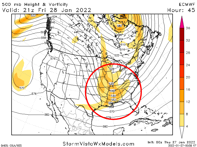
You can see on the map below there are three pieces of energy floating across the US. If these stay as they are essentially separate from each other you end up with small storms across small pockets of the states. What we want to see is these three pieces doing the magic dance and combing to form one big piece of energy like the second image.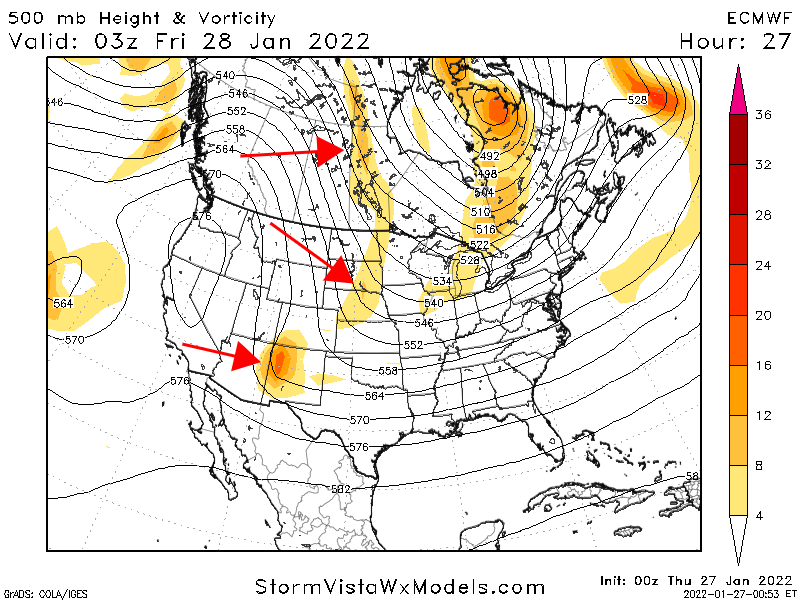
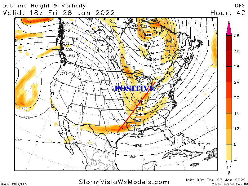
Past runs across models have shown this happening so, what's different? The problem is that previously this phase was staying positively tilted or neutral. When we say "positive tilt", "neutral tilt" and "negative tilt" what do we mean? This is the orientation of that energy. The Euro and NAM have it go neutral early vs. the GFS. This is an interesting song where if it goes neutral to negative just in time you can get a bomb. When a storm is positively tilted it can push moisture too far south. If it's negative it can pull moisture up.
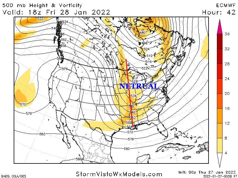
The Euro goes negative just in the nick of time. But what we want to see is for it to go negative just a tick earlier. You can see below all that deep orange and red below. That is a lot of energy which should create dynamics conducive for snow across NC.
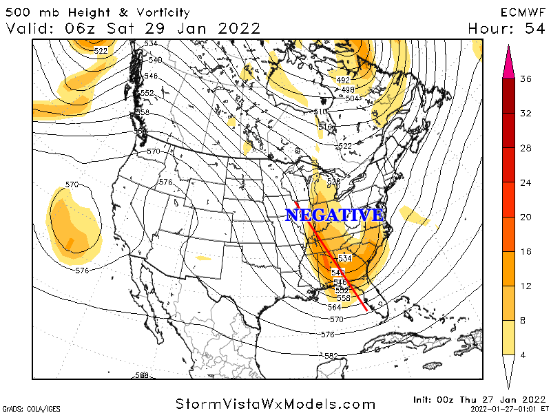
All and all this could be a big surprise if we keep seeing these trends. This has always been reliant on a perfect phase and it's pretty damn close.
Thank you for taking the time to explain these concepts, Burgertime. It is very helpful in understanding what we are look at and for!
-
8
-
-
53 minutes ago, WinstonSalemArlington said:
I was watching the live web cam at the NC State Belltower, and I saw something interesting. A man, alone, slowly walked up the steps to the belltower, turned around to face outward, then standing there he lifted both arms up and tilted his head up to gaze into the snowy sky. He stood like that for about a minute, not moving. Then he slowly lowered his arms, walked down the steps, and disappeared into that snowy scene.
I believe he experienced pure joy at that moment, watching the snow fall. I too know this feeling. I have fond memories of big snowfalls when I was a studnet at NC State long ago, when good snows were more common there. Im glad I was able to re-experience that joy again with him.... good times....
-
13
-
 1
1
-
-
How about a station in the Triad?
-
The ground is starting to turn white now, with heavier snow falling, big flakes!
-
1
-
-
All snow here for 40 minutes, 10 miles south of WInston-Salem. The ground has not started turning white...
-
2
-
-
Mostly sleet now, with some snow mixed in. Ground turning white...
-
Quarter-sized flakes here now, very little rain in it.
-
Snow (half-melted flakes) beginning to mix in with the rain here.
-
17 minutes ago, BornAgain13 said:
Anyone have any ground reports of snow near Winston or Greensboro? Just curious as it heads up this way
It's still just rain here.
-
1
-
-
5 minutes ago, Buddy1987 said:
Anyone have obs in Kannapolis/Hickory/Greensboro? Heavier echoes traversing through there.
Nothing falling here, 10 miles south of Winston-Salem NC, though clouds are getting thick.
-
Raining here, but half-melted snow flakes mixing in now.
I'm 10 mi. south of Winston-Salem NC.
-
Light snow started here about 10 minutes ago (10 mi south of Winston-Salem, NC).
-
Sleet mixed with snow started here, 10 miles south of Winston-Salem NC.
-
Moderate snow here, 31 degrees. Sticking to trees and ground. Starting to accumulate...
Correction - 34 degrees.
-
Light snow just started here (10 mi. south of Winston-Salem NC) , with temp at 41. No rain or sleet before it started.
-
1
-
February 19-20 Obs Thread
in Southeastern States
Posted
We were told to expect a dusting to maybe 1/2" of snow from this morning's snow. It overperformed.
We ended up with 2 inches! It ended with a lot of huge flakes, slowly falling like in a dream...