

ohleary
-
Posts
9,920 -
Joined
-
Last visited
Content Type
Profiles
Blogs
Forums
American Weather
Media Demo
Store
Gallery
Posts posted by ohleary
-
-
This was a lot of work. The current production suite doesn't fill half the system. We, the NWS and global model community are going to grow.
-
You can get into the NWS being other than a Meteorologist.
-
FORTRAN, varieties of C, shell scripting mainly Bash, Python for post processing, then the visualization softwares, NCL, GEMPAK, etc
-
Today!
-
On 11/26/2019 at 8:57 PM, tmagan said:
Apparently, I am seeing the unfortunate fact that EMWIN internet feed is being discontinued on 2 December.
This may help you out:
https://www.weather.gov/media/notification/scn19-88emwin_serv_end.pdf
-
Shocking and we all will miss him around the building.
-
On 10/9/2019 at 6:10 PM, ncskywarn said:
Not sure if this has been posted before but Interesting read.
https://observer.com/2019/08/weather-forecast-noaa-prediction-models-accuracy/
It's garbage in a lot of ways. This, in particular, is hogwash:
QuoteAnother more fundamental problem is NOAA’s reliance on older computer models, which Jacobs calls “legacy forecasting products” that persist in large part because whoever runs them has a direct line to a member of Congress, who then “calls and yells at me” for trying to abandon an obsolete product.
Whatever.
-
This is why they're cautious:
i.e. because people die.
-
On 11/14/2018 at 10:50 AM, Deck Pic said:
You know it is SOP to release an outlook. Whether me or someone else, CWG is always going to do one just like every media outfit. It’s low confidence every year. Which we state clearly. I’ve done one every winter since 04-05. I’d say my average is a C+. I think I’m better than a coin flip or magic 8-ball. But not by much
That's fair!
-
 1
1
-
-
On 11/14/2018 at 10:13 PM, Deck Pic said:
CWG has all my outlooks going back to 05-06. Feel free to look and judge.
Will do.
-
4 hours ago, Tenman Johnson said:
Three or four posters here have been doing this for 15+ years and have a confirmation rate of 65-70%
Show the stats. Would love to see it.
-
looks like sleet to a little mix at IAD for a few hours.
-
Gonna bookmark this for review in April.
I guess if people are asking for it, you have to give them something.
-
 1
1
-
-
On 10/22/2018 at 10:06 AM, jgf said:
In this image, you can clearly see the cold front that has passed over the east coast and moved out to sea.
you can also see the expected cloud development in the vicinity of the front - lot's of cumulus clouds right behind the front and pretty high tops at the front.
I am asking about the clouds that basically are forming right off the coast - they are pretty low, and aligned in a NNW-SSE direction - parallel to the low level winds.., and perpendicular to the cold front
when you watch an animation, the clouds are not really moving offshore - rather they are forming right offshore, and getting entrained in the winds.
so we have cold air moving over warmer water - why are the low level NNW -SSE clouds forming?
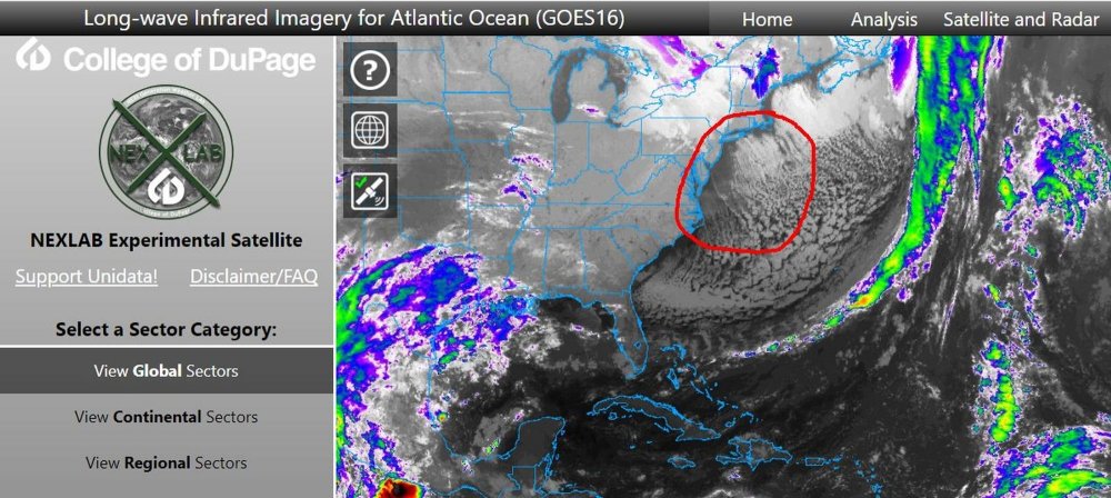
https://earthobservatory.nasa.gov/images/82800/cloud-streets-over-the-atlantic-and-pacific-oceans
-
On 8/21/2018 at 5:04 PM, weatherwiz said:
Not necessarily myself but a few people I'm associated with who are worlds better at computer programming (and have the brain for it unlike me) have dabbled in linux and other ways to extract model data and generate graphics and such. I know there are these links:
https://www.ncdc.noaa.gov/data-access/model-data/model-datasets/global-forcast-system-gfs
http://www.nco.ncep.noaa.gov/pmb/products/gfs/
Does anyone know any other sources where you can grab model data (more specifically for the GFS) and easily choose which parameters and data you specifically want?
Wiz,
NOMADS is exactly what you're looking for. The grib filter is what you use and you can cut any hours, paramaters and even specify your domain out of any of the models. Plus it can be scripted. Lemme know if you have questions.
http://nomads.ncep.noaa.gov/
-
1
-
-
I am seeing on discussion groups that the EMWIN Internet feed will be discontinued at the end of the year. Since some weather alert software programs use that feed, what will be around to replace it?
http://www.nws.noaa.gov/emwin/NWS_EMWIN_Stakeholder_Presentation_E.pdf
-
1
-
-
Sometimes i think the things that inhibit severe can be better to know; dry air, cap, stable marine LL BL, too much shear, lack of mid level lapse rates, no trigger/lift, no cold pool aloft, bad timing, no curved hodo signature, no favorable jet... some obviously already mentioned
Not sure "better" is accurate. Alot of these are just the opposite of features you assess for severe risk...so if you learn what causes severe wx, knowing these is a no-brainer.
We are taught to assess severe parameters and look for severe where they overlap, like on a severe composite map. Then once the threat area is outlined, you assess the features that would hinder it. At least, that's what I'd do.

For example, if you look at severe parameters and find an area where they all overlap, there likely won't be a stable marine layer/lack of ML lapse rates/lack of shear/lack of trigger/no favorable jet/lack of hodo sig/etc there in the first place. You initially found an environment where the opposite of all of these are present. Make sense?
-
CAPE is an acronym for Convective Available Potential Energy, and is used as a metric when identifying the potential for convection (thunderstorm activity). It must be stressed that CAPE is the end all for determining severe weather risk, but is certainly important. Remember that air must have buoyancy (ability to rise) and then condense to form clouds, rain, hail, etc and CAPE provides a measure of this buoyancy. The higher this buoyancy, the quicker air will rise and begin the formation of thunderstorms. The CAPE value is measured in Joules per kilogram (J/Kg) and, generally, you need a minimum of 1,000j/kg of CAPE to see severe weather (Blanchard, 1998). CAPE can reach values of up to 5,000J/Kg, but that is reserved for rare events, such as large scale severe weather outbreaks. Here in the Mid Atlantic a good day is when CAPE gets to ~2,000J/Kg. There are two other types of CAPE talked about in forecast discussions and severe weather outlooks: MLCAPE (Mixed Layer CAPE) and SBCAPE (Surface-Based CAPE). Unfortunately I am not adept at explaining these two terms, but if you were to Google: SPC + MLCAPE or SPC + SBCAPE there are several good snippets of information. Hope this helps!
Reference:
Blanchard, D. O. (1998). Assessing the Vertical distribution of Convective Available Potential Energy. American Meteorological Society, 13, 870 - 877.:
MLCAPE and SBCAPE are just two different ways of initially lifting the parcel. With MLCAPE you average the temp and dewpoint in the lowest 100mb and lift from where they intersect. With SBCAPE, you lift from the surface temp and dewpoint to get your parcel trajectory. For example, in Bob's post above, the parcel looks to be SBCAPE where the traces start at the surface temp/dewpoint. If you try lifting from the average of the lowest 100mb temp/dewpoint, it looks like you would get slightly less CAPE.
-
well you can't live off of 35K a year and support a family.
Engineering... Engineering... Engineering...
Everything else is pretty much toilet paper degree unless you get a masters.
Graduated last year in engineering making 60K a year straight outta the gate
Not true. I "only" have a BS in Meteorology/Mathematics (toilet paper degree) and make 100K+ as a Met. Congrats on your windfall but your statement is patently false.
-
Interesting thread. This thread will probably be responsible for me getting my M.S. in meteorology.

Question for NWS/NOAA employees, what route did you take to get your job? I know it's incredibly difficult to get a government job. But what things can you do increase your odds or to make your resume better?
I work for NOAA/NWS/NCEP, am not a forecaster like most of the folks looking for work on this board seem to want to be. I used to apply to all the intern jobs like everyone else but no dice. I turned down a forecasting job in the private sector right out of school, then got hired as a Support Scientist at the University of Northern Iowa. I am fairly certain that my internship (UCAR/COMET) was 75% responsible for me getting the first job, in addition to my grades, and being active in SCAMS. Alot of what I did at UNI was computer-related, I came out of there being an adept administrator of Windows/UNIX/Linux, shell scripting, GEMPAK, WRF/Workstation Eta modeling, web stuff. I then took a job in NC as an air quality meteorologist after 4 years in Iowa, then saw the announcement at NCEP/NCO. My experience at my job in Iowa pretty much got me my current position, because of my experience with shell scripting, computer administration and experience running numerical weather models. Plus always have stellar references.
For me it was hard work and alot of luck, one thing led to another, and the pieces all fit together. I couldn't get a forecasting job at a WFO now probably, but I think I'm past that now anyway. I don't know exactly what to tell you about getting a job with the NWS now, other get an internship in school and be amazing at it, so that you have sterling references from it. Don't overlook the private sector, right out of school, get experience doing anything at all, anything computer related, GIS, community outreach, etc. And when you are somewhere and have stopped building skills, move on to another position. Don't be afraid to move anywhere. At the beginning of your career you shouldn't stay anywhere long. Build a resume with varied experience, everyone and their brother has a Met degree. Looking back, I'm sure my Met degree didn't get me any jobs, it was all the extra stuff that did and learned along the way that tipped the scales.
-
There is something there, but hobbies generally don't pay the bills.
Let me say this. Every successful meteorologist, meaning every meteorologist that was happy with his/her career, that I have ever met, has known since they were young that they wanted to be a meteorologist.
If you're doing it because it's interesting, you probably don't love it enough to persist. I find it's a calling, if you think of it as a hobby, maybe keep it a hobby.
-
Yes, outside of the USA but no, not Siberia.
When looking for work after graduation I applied for a job way out in the middle of the Pacific, I think at the Kwajalein missile range. They called my references but I didn't get called. Would have taken it! I ended up in Iowa.

-
Yeah. You definately have to turn over some rocks to find the good jobs and be open to moving. I did that and the job I have now is ouside of the country.
Outside of which country? The US of A? Are you in one of those SiberiaFO positions?
-
We all know this is a difficult field to get into. I have been very fortunate though as I graduated last year and didn't get one, but two jobs!
What helped me get started was my internship at a television station. I wasn't sure I wanted to do tv, but I knew I did not want to do research because I was not good at the math. So I interned at a station in DC and then after searching for a tv jobs for 5 months after graduating, they offered me a job as a weather producer. I think much of it is luck, but I also worked very hard as an intern.
At the same time, I was offered a job as a weekend meteorologist in Salisbury where I work now so I work 6 days a week and sometimes 7 days a week. Yes, it is hard and a lot of traveling, but I enjoy doing both jobs most of the time. I just keep telling myself that this isn't going to be like this forever and it is temporary.
If you like it enough, you will find ways to make it work and again I think a lot of it has to do with being at the right place at the right time and having connections as well.
Don't give up if you have your heart set on it. Most of my friends that didn't decide to go to grad school have jobs now so there are jobs out there.
I think in alot of cases internships are key to getting a job after graduation. Partly because of on-the-job experience you can put on your resume, but partly because sometimes they turn into actual jobs. I and three of my classmates got internships at NCAR at about the same time, mine unfortunately didn't but two of theirs turned into full-time jobs after graduation. The other guy is now the Chief Met at Colorado Springs TV station. But, my internship directly got me my first job, after I had turned down one position in Houston. Of course this was in 2000 when the job market wasn't so depressed. But I think with great grades, strong computer skills (Unix, shell scripting, Perl, FORTRAN), and a strong internship and yes, luck, you will be a shoo-in for finding work after graduation. It helps too to not be picky and to be able to move anywhere.

Winter 2022/23 Banter Hangout
in Lakes/Ohio Valley
Posted
your power here is unimaginable. we all thank you for your mercy.
lol