

blue60007
-
Posts
890 -
Joined
-
Last visited
Content Type
Profiles
Blogs
Forums
American Weather
Media Demo
Store
Gallery
Posts posted by blue60007
-
-
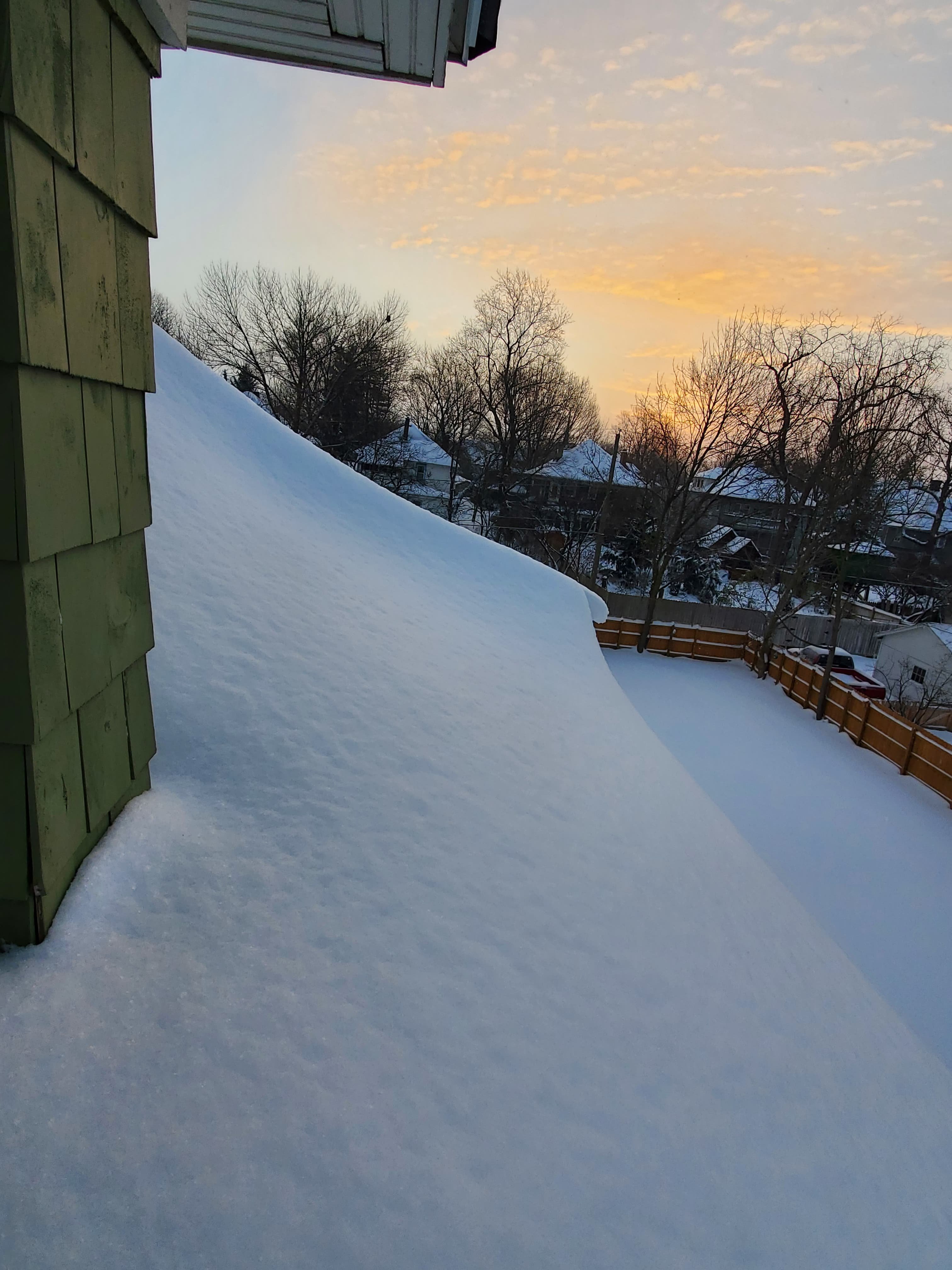
Leaned out the upstairs window. Good 3 foot drift on the edge of the roof. Really impressive.

-
 4
4
-
-
Just barely broke double digits here. Storm total 10.2 inches. Some drifts approaching 2 feet. Not bad at all.
-
1
-
-
Coming up on 8 inches here. Might just make double digits.
-
2
-
-
Flake size increasing here, on schedule, I believe.
-
4 inches here in IND and some pretty significant blowing and drifting, for the fairly dense/urban part I'm in. An hour to clear the sidewalk and driveway, and had near an inch covering where I started by the time I finished. Some nice weenie bands forming now down by EVV which should be fun later.
-
Already ripping here, a bit ahead of schedule.
-
Impressive
(sorry, not sure why it made the image so massive)

-
2
-
-
2 minutes ago, Chicago WX said:
Sh*tty government model version 16

Lookin' solid here.
-
1
-
-
4 minutes ago, Snownado said:
Will there ever be a time when technology is so great that models can forecast the exact weather with 100% accuracy 7 days out ?
IMO the biggest challenge is getting the initial conditions correct. A 100x more powerful supercomputer can't take detailed in-situ upper air measurements over the pacific. This is why using ensembles are so important when forecasting more than a couple days out.
-
2
-
-
Just now, Frog Town said:
So why is everyone's forecast hedging towards the GFS operational in their AFD's??
At a minimum I doubt they can use an experimental/non-operational model in an operational forecast.
-
7 minutes ago, Jim Martin said:
If I recall correctly, the Kuchera takes into account the actual air temperatures.
It does, and it takes into account the entire thermal profile (not just air temps). That said, the weather bell implementation is totally wonky, or they are purposely inflated. Their maps are always bonkers. The pivotal ones are more true to form, and slightly more realistic.
-
3 minutes ago, Gino27 said:
Looks too good to be true given the way these had evolved over the past 5 years. There's always going to be a catch that shows up in the short range (dry air, mixing, shunt in track etc...)
I hear you. I'm trying to not even look at the follow up storm later in the week just yet.
-
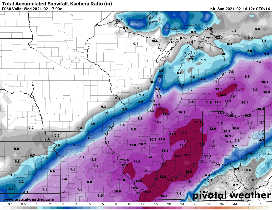
12z GFS with strong support from GEFS for a solid hit across much of IN and OH. GEFS seems a tad further NW of the op with the heaviest stripe. Looking solid for those of along and south of I-70. The extended range of the NAM supports a GFS solution as well.
-
1
-
-
1 hour ago, zinski1990 said:
I'll give it another day or so. If it doesn't trend back nw I'll give up.
Many of yesterday's 12z EPS members brought mix/ZR/rain up into central IN. The 0z and 6z EPS looks like a better track - very few mixing issues here, albeit drier. The GEFS is a similar situation. I like where we're at ATM, though do need to monitor any weaker/more sheared/drier trends today and tomorrow.
-
Nice banding showing up across KIND, snowing nicely here, clearly some good forcing overhead. Good flake size, and looks even heavier to the east. Wasn't expecting anything so soon.
-
Sleet and giant snowflakes here. Wind picking up.
-
The sleet fest continues here. More flakes starting to mix in.
-
Sleet here with a few flakes mixing in. Should be rain soon
-
The 6z EPS bumped back north and with tighter clustering. Many of the members look like the 6z parallel GFS. Ratios should be decent, so this wouldn't take much qpf to drop several inches.

-
1
-
 1
1
-
-
Haven't posted in a while but thought this was a good reason to... just had a loud clap of thunder about 5 minutes ago on the east side of Indy!!! I'm eyeballing about 4 inches on the ground here.
-
7
-
Feb 17-19th Potential Of Potential
in Lakes/Ohio Valley
Posted
Nice fluffer here. I haven't been out to measure, but eyeballing close to 2 inches. Looks like we might make a run at 3 based on radar.