

toller65
-
Posts
238 -
Joined
-
Last visited
Content Type
Profiles
Blogs
Forums
American Weather
Media Demo
Store
Gallery
Posts posted by toller65
-
-
Winter, meet Mr. Fork......The whole winter has.
Sent from my SM-G935V using Tapatalk
-
 1
1
-
-
You on Oh My Gosh corner? My camp is about half mile further up in Sugarloaf Village 2.Can see the top of the loaf this morning, Looks like they got 3” yesterday.

Sent from my SM-G935V using Tapatalk
-
 1
1
-
-
Pouring sleet in Yarmouth Maine...
Sent from my SM-G935V using Tapatalk -
Less than 12 hrs to go time in PWM area and we still do not have model consensus.... a range of 6" to 20" leaves me wanting for some clarity...
Sent from my SM-G935V using Tapatalk -
Could you give us a peek at ME/NH/VT? GraciasHere is the 12z EURO snowfall map with actual deformation zone encircled....this is where some 18-20" amounts may verify based on this run given H7 track.
Probably wouldn't be as much subby east of it, as there normally may be due to 850 inflow, but I would not want to be west of it, looking in from the CTRV....subsidence+deformation may equal some single digits.

Sent from my SM-G935V using Tapatalk
-
Agreed Tip, Casco Bay has been unusually calm these past two weeks...noticed others commenting on the sensible weather as of late ....
I can only add, I don't recall a January with wind this still. Specifically that one particular metric... In the last 10 days, I've seen two days where flags wobbled...as in, zephyrs all but unnoticeable ..otherwise, it's been almost calm the whole time.
( there may be an afternoon that I am forgetting but for all intents and purposes - )
That's getting extraordinary ... We are approaching the perennial windiest time of the year for Logon ...can't imagine that's not the case everywhere else around here just the same.. Here we are again, ...no wind. And frankly, the temperatures, general appeal, other than a couple few cloud afternoons as others have noted... these other aspects are remarkable fixed. We have also seen an exceptionally long duration of fair to sun sky. Although that's a different metric than wind - just sayn' pretty remarkably quiescent
Sent from my SM-G935V using Tapatalk
-
35/34 in Yarmouth, ME on the bay... changed to rain /snow mix at noonYeah I'm thinking our coastal areas up this way could do a rain-snow-rain-snow scenario.
Sent from my SM-G935V using Tapatalk
-
1
-
-
3 minutes ago, dryslot said:
H7 just to the SE of here
Some reason i was on the snow depth.
Even Casco Bay gets in on the action....
-
1
-
-
Could be the float is stuck, shut off the fuel valve and tap the float bowl on the bottom of the carburetor with a metal wrench a few times.Not looking forward to this...started up the generator today and it has a fuel leak. Wasn’t able to get it fixed. Hoping this one under delivers.
Sent from my SM-G900V using Tapatalk
-
My son is driving I-90 east at the NY/Mass border, says it is dumping snow, visibility a little over 50 yds
-
PWM to Keene is a coop crusher
-
Already approaching max 2-day GYX 10% probability forecast total for PWM of 4"
Sent from my SM-G900V using Tapatalk -
My bro-in-law owns Ayotte's and Annie's and my sons work for him during school vacationsSure do, Right next to Ayottes Store, It’s gone now, Empty lot but some wild times there. Lol
Sent from my SM-G900V using Tapatalk
-
2
-
-
Judson's and bartender Al Baine...those were some distorted eveningsDo you rememberJudson’s? Oh’ man!
All of NNE should do well this week.
Sent from my SM-G900V using Tapatalk
-
 1
1
-
-
QPF phail in Yarmouth ME1.5" here, Maybe we can squeak out another 1" or so.
Sent from my SM-G900V using Tapatalk
-
1
-
-
38 minutes ago, EastonSN+ said:
Speaking of Fairfield county. Per capita
who cares
-
1
-
-
32.0 F in Yarmouth, Maine on the water - sleet and rain mix
-
11 minutes ago, Baroclinic Zone said:
We take a 0.6 multiplier and that the realistic winds.
Curiosity: Is the 0.6 multiplier "calibrated" to winds over land? Put another way, do you think the 0.6 multiplier is valid for winds coming from the ESE on the Mass/NH/ME coast with significantly less friction over open water?
-
8 minutes ago, HIPPYVALLEY said:
That's an intense road at night. Even coming through Belgrade Lakes but yeah, the S curves between Kingfield and Carrabassett are no good in bad weather.
Last Friday night's drive from 8-11PM was a nightmare - sublimating snows reduced the visibility in fog to less than 50 feet in some places. If I go up it will be Thursday night before any precip starts.
-
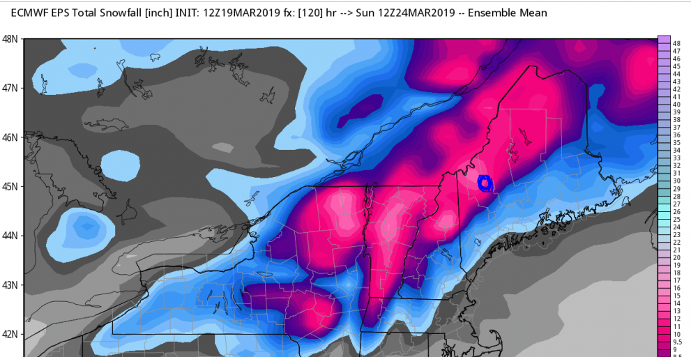
Okay folks, hate to do this to you, but if you took your best shot at crystal-balling the p-type at Sugarloaf elev. 4,297 ft (blue circle on map below) for the Thursday-Friday event, what would it be?
1) Moderately fluffy snow (10:1)
2) Heavy, wet snow (7-8:1)
3) Mix
Trying to plan the rest of my week in hopes of taking Friday off
")
-
1
-
-
I'm just hoping to get 6" at the Loaf to cover the ice after Sat/Sun re-freeze....
-
It's a good year at Sugarloaf, over 210"N greens are magic , nothing compares in east for totals . It’s a good year if someone in Maine or NH is within 100”.
Sent from my SM-G900V using Tapatalk
-
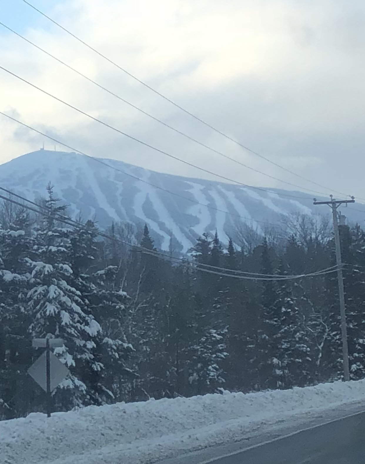
Sugarloaf ski resort reached 206" for the season on Sunday, may be some epic spring skiing
Sent from my SM-G900V using Tapatalk -
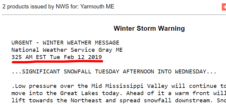
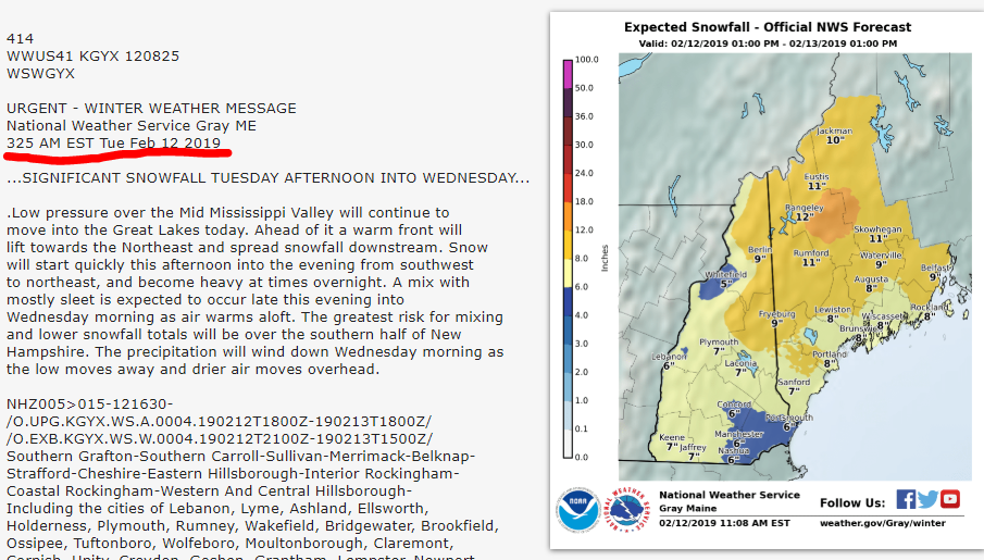
Here's an "observation"......GYX has not updated their WSW since 3:25AM this morning...hello?
March 2021 Weather Discussion
in New England
Posted
Sent from my SM-G935V using Tapatalk