

miller.b.time
-
Posts
155 -
Joined
-
Last visited
Content Type
Profiles
Blogs
Forums
American Weather
Media Demo
Store
Gallery
Posts posted by miller.b.time
-
-
Here are some photos I took of damage in Carmel. It’s pretty well confined as far as I can tell to a path of about a couple of hundred yards long, maybe a hundred yards wide. Hard to tell in the dark, obviously. But we were fortunate.
-
 2
2
-
-
-
1 hour ago, mimillman said:
Yea I don’t know where all of our Indy posters went but 2 years ago this thread would be bonkers
I’m too cautious to get overly excited lol
-
I have never clung to the Canadian more in my entire life lol
-
 2
2
-
 3
3
-
-
Funnel cloud reported on the storm in Hamilton Co. May be TOG.
-
IND decided to go with a madlibs AFD this afternoon, it appears. I think their glossary links aren’t rendering correctly lol.
Overnight through Wednesday...

Multiple rounds of  are expected late tonight through the
day Wednesday. Strong  and plentiful  will be present
throughout the day. Strong winds will be present not far off the
surface and will be able to be brought down. Thus, it will come down
to available  and  features created by
.

Believe there are at least a couple of potential scenarios for
Wednesday, similar to previous thoughts...

1) Strong to severe  will persist from the Ozarks into
central Indiana late tonight into early Wednesday morning. After
this, there will be a lull before more  develops along the
cold  by mid afternoon. Severity of the second line will depend
on how much  builds between the two rounds.

2)  from the Ozarks weakens before it arrives here and
dissipates across the area. Additional thunderstorms develop in
 mid morning to early afternoon. This  may be
severe if  is able to build enough. Additional
then forms along the  later in the afternoon, which may be
severe if  can recover.

In summary, enough ingredients are there so that some severe storms
are . Damaging winds will be the highest threat, but given the
amount of , potential boundaries from previous rounds of
, and at least a low threat of discrete cells, tornadoes
and large  are also certainly possible. Uncertainty is on when
and where the highest severe threat will be.

The aforementioned strong winds mixing down will bring wind gusts up
to 40-45 mph even outside of storms. Odds of widespread areas Wind
Advisory criteria are borderline, but would rather err on side of
caution, especially with some recovery efforts ongoing from last
Friday`s tornadoes. Will go with a Wind Advisory from 12Z-00Z.

Highs on Wednesday will be in the 70s, even with clouds and rounds
of storms.
-
1
-
-
This is just insane.
-
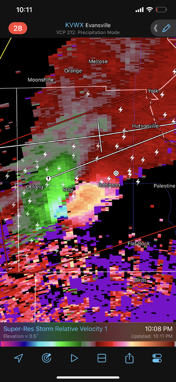
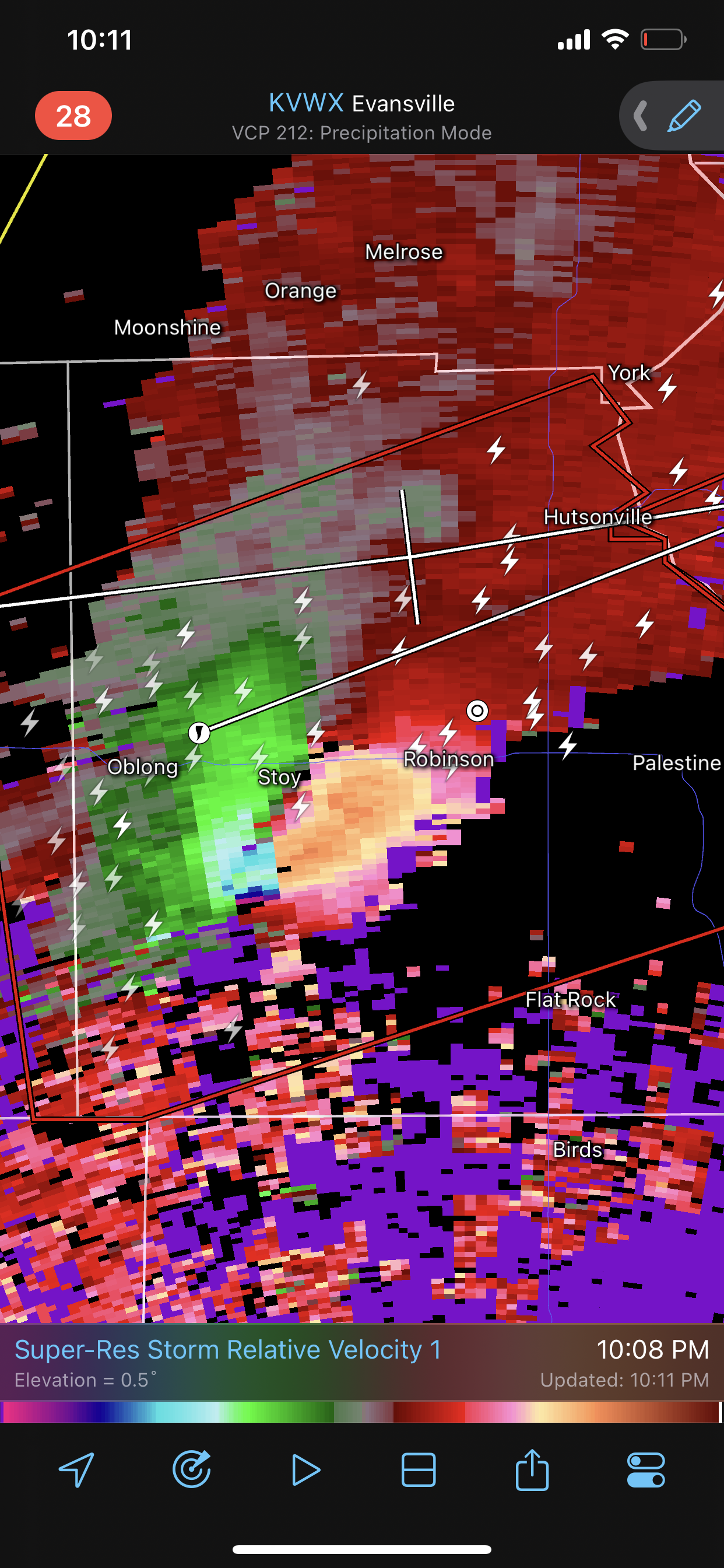
The National Weather Service in Lincoln has issued a * Tornado Warning for... Crawford County in east central Illinois... Southeastern Jasper County in southeastern Illinois... * Until 930 PM CDT. * At 858 PM CDT, a large and extremely dangerous tornado was located over Ste. Marie, or 10 miles east of Newton, moving northeast at 60 mph. This is a PARTICULARLY DANGEROUS SITUATION. TAKE COVER NOW! HAZARD...Damaging tornado. SOURCE...Radar indicated rotation. IMPACT...You are in a life-threatening situation. Flying debris may be deadly to those caught without shelter. Mobile homes will be destroyed. Considerable damage to homes, businesses, and vehicles is likely and complete destruction is possible. * The tornado will be near... Hardinville around 905 PM CDT. Robinson, New Hebron and Eaton around 910 PM CDT. Palestine and Hutsonville around 915 PM CDT. -
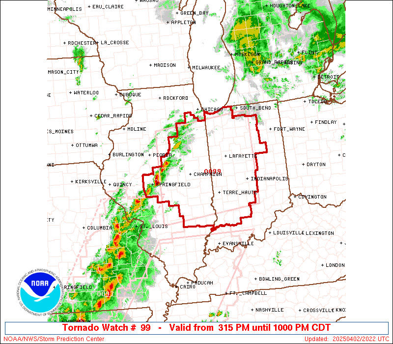
URGENT - IMMEDIATE BROADCAST REQUESTED Tornado Watch Number 98 NWS Storm Prediction Center Norman OK 700 PM CDT Fri Mar 31 2023 The NWS Storm Prediction Center has issued a * Tornado Watch for portions of East-central and southeastern Illinois Western and central Indiana Western and central Kentucky Extreme southwestern Lower Michigan Lake Michigan * Effective this Friday night and Saturday morning from 700 PM until 200 AM CDT. * Primary threats include... A few tornadoes likely with a couple intense tornadoes possible Widespread damaging winds and isolated significant gusts to 80 mph likely Scattered large hail and isolated very large hail events to 2 inches in diameter possible SUMMARY...Several clusters and lines of severe thunderstorms will sweep across the watch area through the evening, offering the full spectrum of severe hazards: tornadoes (a few strong), severe non-tornadic thunderstorm winds, and sporadic large hail. The tornado watch area is approximately along and 80 statute miles east and west of a line from 20 miles east of Fort Campbell KY to 10 miles northwest of Lafayette IN. For a complete depiction of the watch see the associated watch outline update (WOUS64 KWNS WOU8). PRECAUTIONARY/PREPAREDNESS ACTIONS... REMEMBER...A Tornado Watch means conditions are favorable for tornadoes and severe thunderstorms in and close to the watch area. Persons in these areas should be on the lookout for threatening weather conditions and listen for later statements and possible warnings. && OTHER WATCH INFORMATION...CONTINUE...WW 93...WW 94...WW 95...WW 96...WW 97... AVIATION...Tornadoes and a few severe thunderstorms with hail surface and aloft to 2 inches. Extreme turbulence and surface wind gusts to 70 knots. A few cumulonimbi with maximum tops to 500. Mean storm motion vector 24045. ...Edwards -
Looks like it’s finally on the verge of completely changing over we just N of Indy. Still a few pingers mixing in, but otherwise SN
-
1
-
-
Latest from IND:
.Mesoscale Update...
Issued at 543 PM EST Wed Feb 2 2022

Baroclinic zone continues to drift south this evening, currently
stretching from near Terre Haute northeast through Indy Metro to
Muncie, where temperatures continue to fall with the robust
northerly flow ushering in sinking cold air to the surface. The area
of 850mb frontogenetical forcing continues to be parked across
Northeast Missouri stretching northeast through Illinois into
Indiana. Last few hours this zone of FGEN hasnt moved much, and
current hi-res guidance continues to favor this stubborn movement
through this evening.

Precipitation footprint continues to be expansive across Central
Indiana, associated with the aforementioned FGEN zone is an area of
800-750 EPV lifting north along southern periphery, which will ride
along the isentropic surfaces and continue to create the unstable
layer. This should continue the precipitation footprint overnight,
but with thermal profiles steadily cooling expect the partially
melted hydrometeors stretched over the Avon/Brownsburg to switch
over to all dendritic form. Parcels will continue to be pushed
vertically through the dendritic growth zone and enhance the
snowfall rates through the evening hours from north to south.

This further complicates the evening commute home, likely causing a
longer commute for those that are encountering the sleet/snow
mixture. WIth the elevated instability causing the increased rates,
this should lead to some aggregation of dendrites from some marginal
warmth and further reduce visibilities. But expect with additional
loss of heat in the low-levels of atmosphere this will lead to drier
dendrites and thus begin to increase the SLR values.
-
3 minutes ago, Jackstraw said:
Think we finally flipped to SN for the foreseeable future hopefully. Waiting on that transition hurt as bad as stubbing your toe after getting up for a 3am pisser.

I’ve already started smoking a cigar in anticipation of the changeover here. When that happens, then it’s time for drinks.
-
1
-
-
Threat was fun while it lasted down here lol
-
1
-
-
Live look-in at IND’s current thinking:

-
1
-
6
-
-
-
Just now, mimillman said:
Can’t believe no one mentioned the ICON shifting northwest. We have the dream team on our side.
May be time to revamp the DGEX
What’s the MM5 up to these days?
-
2 minutes ago, Jonger said:
What's the verification rate on that model?
Sixty percent of the time it works every time.
-
 1
1
-
-
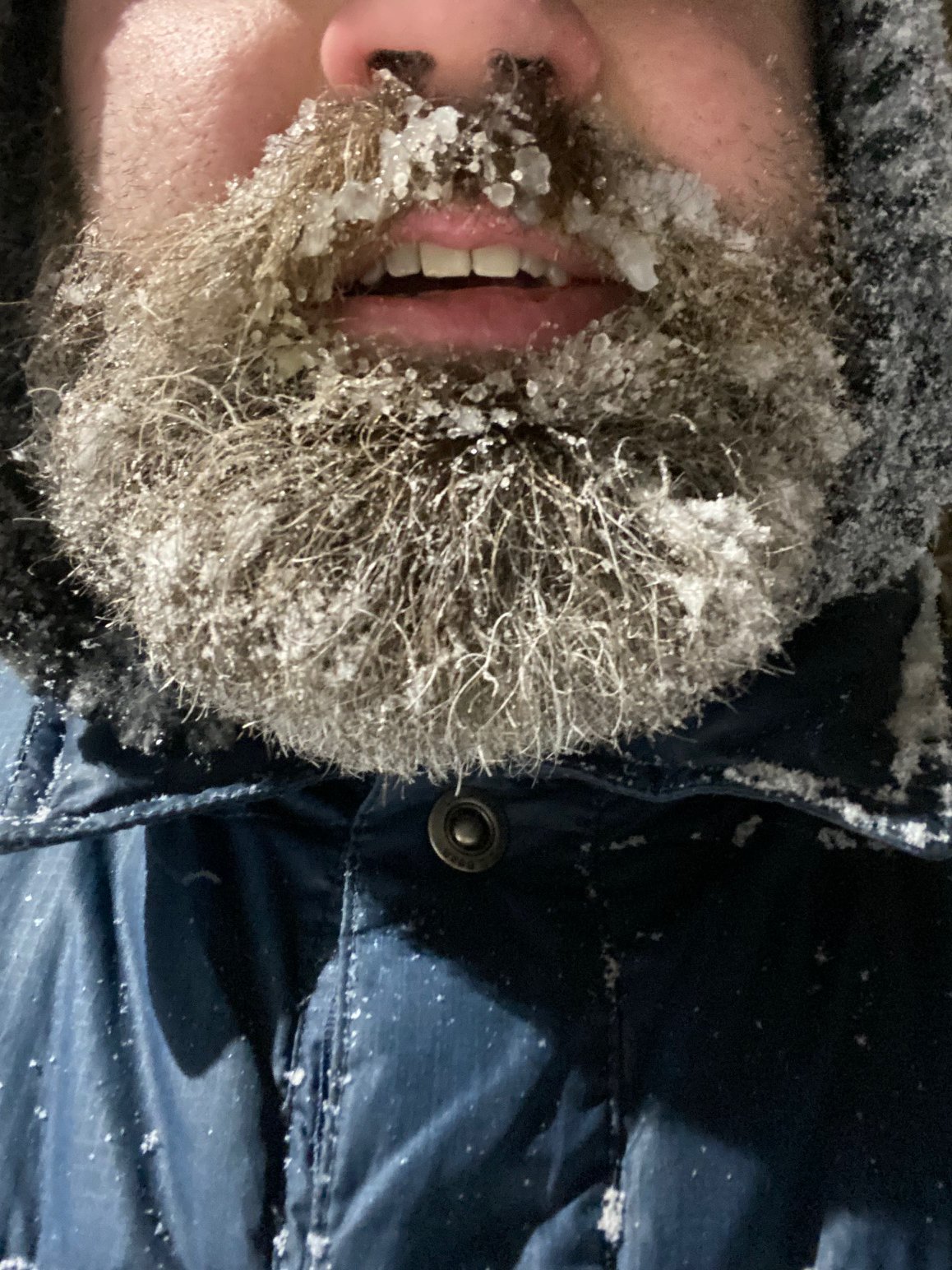
Always a good jebwalk when your beard looks like this at the end

-
9
-
1
-
-
1 minute ago, StormfanaticInd said:
Some of the heaviest snow yet!!! WHITEOUT
Send it up north just a little when you're done with it.
-
1
-
2
-
-
1 minute ago, Snownado said:
Is anyone here other than in Chicago getting snow ?
We boutta get back in them good (or at least decent) rates.

-
2
-
-
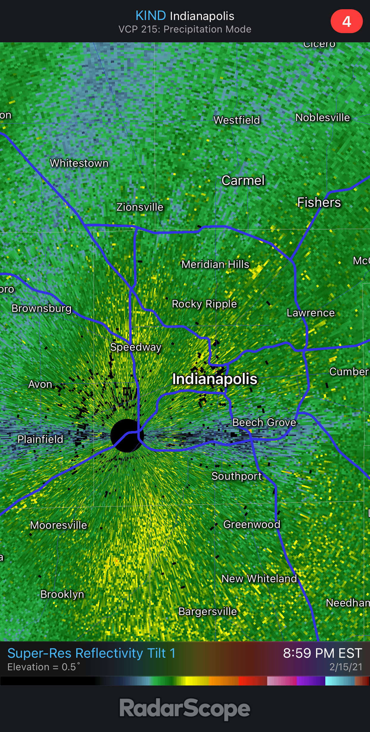
Latest IND mesoscale update:
Quote.NEAR TERM /619 PM EST MESOSCALE UPDATE/... Expansive area of moderate to heavy snowfall continues across central Indiana early this evening. Winds have steadily increased across the region with a progressively tighter surface pressure gradient as low pressure tracks into eastern Tennessee and the presence of stronger boundary layer winds aloft. Beginning to see gusts routinely exceed 30mph since about 21Z and expect that to persist into the evening. Forecast remains on point going into the evening and while snowfall has been very heavy already late this afternoon...several factors point to the most intense rates still set to come...likely in the 00-04Z timeframe. May see a very brief lull through about 00Z in some areas where snow rates relax ever so slightly. However...another surge of lift and a progressively deeper plume of moisture advecting into the region will match up with excellent mid and upper level diffluence over the Ohio Valley to enable heavier snowfall rates to reestablish across the forecast area for a good portion of the evening. Hints of a TROWAL feature lifting northeast across the southeast half of the region over the next 3-4 hours will aid in an intense burst of low level lift to run in tandem with the deformation axis which is set to align just northwest of the path of the 850mb low. At this point...that is likely to set up in a SW to NE direction bisecting the forecast area in the vicinity of a Bloomington-Indy Metro-Muncie line. This is where the most intense snowfall this evening should set up with 1-2 inch/hour rates easily being met for about a 3-4 hour window through 03- 04Z. Sweetening the pot is a piece of the low level jet getting pulled up and around the top of the 850mb low...and aligning directly back into the forecast area from the northeast for a couple hours this evening. This will only enhance snowfall rates further. There remains a component focused on conditional instability as well with higher PWAT air advecting into the southeast half of the region over the next few hours and interacting with the strong low level lift. Satellite imagery earlier in the afternoon was hinting at cloud congestion and weak but notable instability in play. Would not rule out a couple rumbles of thunder and lightning strikes in the vicinity of the most intense bands into the evening. The DGZ remains robust through the evening which also supports the continued threat for big dendrites within the heaviest bands and potential for accentuation of snow ratios above the 12 to 15-1 we have been seeing up to this point. At the same time...the colder air will be drawn in from the northwest as the surface wave passes through the eastern Tennessee Valley and should naturally bump up snow ratios through the evening in addition to the boost from any intense lift in the vicinity of the deformation axis. At a minimum...expect these higher ratio potential to coincide with the heavier snow fall for at least a few hours. So taking all of the above into account...several hours of accumulating snow remain for central Indiana. It appears that the 00-04Z timeframe will be the storm sweet spot for the forecast area for the heaviest and most efficient snowfall. An additional 4-8 inches above and beyond what has already fallen looks likely considering above thoughts with potential for locally higher amounts where mesoscale banding sets up in the vicinity of the deformation axis. Wind gusts routinely around 30mph will maintain significant blowing and drifting of snow through the evening and even well through the overnight once snow has diminished.
-
3
-
-
6 minutes ago, BigHoss said:
Talk me out of this busting HARD in IND
IND still seems very much to think that this is on track to verify as expected. We're not in the true heart of the event yet, which should begin in a couple of hours, if I'm not mistaken.
The 3:30 disco from IND is worth a read to put your mind at ease:
Quote.Mesoscale Update... Issued at 330 PM EST Mon Feb 15 2021 Satellite imagery continues to blossom over the Ohio Valley this afternoon, with water vapor indicating growing depth of atmospheric moisture. Visible satellite imagery indicates some convective layers across Western TN/KY, which is all steadily advecting north and expected to move across Central/Southern Indiana later this evening. Precipitable water at the sfc is also on the rise, with values ranging from .4 inches across the north to .6 inches across Southern Indiana. Radar reflectivity across the area continues to be on the rise in volume and intensity this afternoon. The next line of stronger snowfall is approaching Crawfordsville to Edinburgh to Rushville line. This area was steadily lifting north and expected to be in the Indy metro area by 4pm. Vertical lift in the lower levels will be robust this evening as well, which should aid in dendrite size growth and volume as the greater snowfall rates increase. Further compounding the complexity to the atmosphere is the layer of anomalous warm/moist air steadily advecting north, eluded to in the prior discussion in regards to the precipitable water. Thermal profiles indicate that dendrite size should increase marginally over the next few hours, coupled with the deeper moisture aloft. Unfortunately pressure change will become mixed to the surface, pushing gusts to between 20-30 mph, further exacerbating conditions bringing visibilities down to less than 1 mile frequently, due to the fine dendrite size. Cant rule out whiteout conditions periodically this evening as well. The main concern for this evening will be on the precise path of the 850mb low. Typically in more robust winter storms this indicates the location of the deformation axis, which is also the location of the heaviest snowfall due to the forcing and supportive atmospheric conditions. Timing for this feature still progged to be in the early/mid evening timeframe across Central Indiana.
-
1
-
-
Just now, Snownado said:
I'm in dead center of Carmel also !
Carmel partayyy lol
Does look like there's some 30+dbz stuff in Indy moving N as we speak.
-
1 minute ago, schoeppeya said:
It actually looks like they improved a little bit at my location (dead center Carmel) while we were talking about it.
Yeah, I'm starting to see some bigger ones mix in down on 106th, too.

4/2-4/3 Potential Major Severe WX Outbreak
in Lakes/Ohio Valley
Posted
Video of the tornado that hit Carmel: https://fixupx.com/topshotkief/status/1907620779577028913?s=46