

shadowsintherain
-
Posts
216 -
Joined
-
Last visited
Content Type
Profiles
Blogs
Forums
American Weather
Media Demo
Store
Gallery
Posts posted by shadowsintherain
-
-
1 minute ago, weatherlogix said:
NAM looks horrid....
You could be more... specific?
-
 1
1
-
-
Very light snow just east of route 110 here in Copiague. Just started.
-
Anyone know where the low is right now? Got a map?
-
Down to 30º here in Copiague. Wet bulb is at 24º.
-
Stronger high maybe can keep things a little more south
NEAR TERM /UNTIL 6 PM THIS EVENING/...
-- Changed Discussion --
Forecast is generally on track. Temperature are a bit cooler than previously forecasted, so lowered hourly and max temperatures today. Also, winds are higher, so increased wind speeds through the morning. This may be due to slightly higher pressure in southeastern Canada than the models were showing previously. High pressure will remain north of the region today. Meanwhile, a shortwave over the southern states will become negatively tilted, resulting in an area of low pressure to develop off the mid-Atlantic coast later this afternoon. This low will travel northward, parallel to the coast into late afternoon. In terms of weather in our local area, expect clouds to increase from the late morning through the afternoon. By late afternoon, we should start to see some light snowfall move into the area, mainly from southwest to northeast. It is possible that it won`t be until after 6pm, that portions of Southeast CT or Long Island see any precipitation. Temperatures today will range from the upper 20s to middle 30s.
-- End Changed Discussion --
From the looks of the radar I think we will be snowing by 2pm. Hmmm.
.-
2
-
-
2 minutes ago, MJO812 said:
I'm wondering if the models have the warmth wrong if heavy precip falls
One can only hope. I would imagine if a wall of snow starts to fall, the entire column should cool. But, I am not nearly experienced enough to know if that is indeed the case. The southerly winds off the water will be significant. Let's hope to low goes even further east tomorrow!
-
1
-
-
Yeah, not loving that 540 line above the city and island on both of those panes. Hmm... What a PITA this forecast must be for the pros. Good God! That being said. That's 2.0" liquid verbatim. Wow.
-
1
-
-
2 minutes ago, MJO812 said:
Low resolution maps
Its all snow
How is it all snow? According to those maps I'm seeing tons and tons of sleet on the south shore, no?
-
WWBB was before that or about the same time. Lotta years ago...
Ahh the good old days! Can’t believe I’ve been watching you folks that long! My God. Where does the time go???
.-
 1
1
-
-
WOW WRF NMM SLAMS US
Map?
. -
i spent many nights staying up late to see what the euro said. i should not have gotten suckered into a storm unless it was absolute certain it would be a big snowstorm for the city
When is anything absolutely certain in the weather? Lol
.-
2
-
-
12 minutes ago, MJO812 said:
Maybe
Agreed. We should all know that you can never take anything to the bank, even from less than 48hrs to go. Trends are important, but, they aren't gospel until the storm hits us and they actually verify. Keep the faith!
-
If this corrects south again tomorrow, it's gonna be bedlam in here! lol Good night all. Here's to the south trend returning at the last second!
-
2
-
-
We still have a full day's worth of model runs tomorrow. Don't commit suicide yet! (I know the trend is not our friend here.) But, we have seen this happen before where the models corrected again at the last minute. One can only hope.
-
Ahh, yes. The Pamela Anderson storm? ;-)
Sent from my iPad using Tapatalk
Actually wait, wasn’t that in March 2003?
Sent from my iPad using Tapatalk -
Lol to the Dec 2003 mention. That was a NE event. And Jan 2016 show distribution looks ZERO like this in NYS or central PA
I'll give you Feb 2003, but that was mid winter with very low temps. But not really an analog
Ahh, yes. The Pamela Anderson storm? ;-)
Sent from my iPad using Tapatalk -
How bad are the winds on this run?
Sent from my iPad using Tapatalk -
2 minutes ago, friedmators said:
Euro is pretty windy even with its tendency to over do it. Blizz warnings NE NJ?
I would think for the island, too, no? Things could get hairy pretty much everywhere. Unless the 3hr wind criteria won't be met?
-
So, how likely are we to get the B-word thrown around sometime soon? Are winds high enough and sustained for over 3 hours to accomplish that?
-
-
2 minutes ago, MJO812 said:


These panes show 2.00" potential liquid total for a LOT of the subforum. Wow.
-
2
-
-
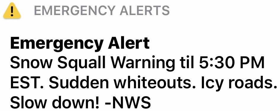
Anyone else get a snow squall warning on their phone???
-
Already below freezing at 31º in Copiague, Southwestern Suffolk.
-
There go the warnings!
.

Major Nor'easter snow storm (possible top 20) Noon Wednesday-Noon Thursday Dec 16-17, 2020
in New York City Metro
Posted
10-12" for the south shore? I'll take it!