

matt9697
-
Posts
132 -
Joined
-
Last visited
Content Type
Profiles
Blogs
Forums
American Weather
Media Demo
Store
Gallery
Posts posted by matt9697
-
-
So what are the chances we break the crap winter pattern we have been in the last few years next winter??
-
 2
2
-
-
Honestly think this is going to be a non event but could be wrong!
-
47 minutes ago, Carvers Gap said:
The 12z RGEM and 12z GFS both have an event west of the Plateau...that includes portions of middle TN and most of west TN. The RGEM is at range so TIFWIW. That would include multiple waves.
Well thats interesting
-
9 minutes ago, Carvers Gap said:
Looking like a western TN even this go round - on a positive note, glad to see regular moisture though as we head into Spring. Last Spring and Summer were too too dry in Middle TN
-
1
-
-
4 minutes ago, Carvers Gap said:
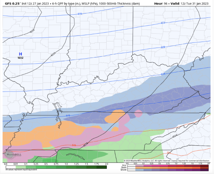
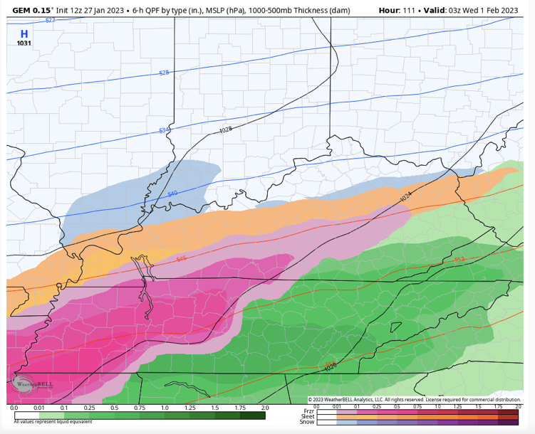
Nah. 12z update.... The CMC is a pretty bad ice event for middle and west. The GFS is a nice 2-4" slider for much of the state north of I-40. With so little agreement....I think we are all just chilling and waiting for some agreement. Here are a few snapshots. The models are consistent within their own runs but now with each other....
Yea, I had forgotten about the canadian which has been sounding the alarm all week
-
1
-
-
Judging by the activity in here I get the feeling that next weeks system is going poof
-
1
-
-
3 hours ago, Matthew70 said:
I will take a HARD PASS on any ice! The extreme cold temps already damaged many of the evergreens & shrubs. Sheesh last thing we all need is trees to be damaged also.
The latest Canadian is showing a west tn event hardly anything middle tn
-
1 minute ago, Carvers Gap said:
Euro had it at 12z. We are also talking the 105 hour....not day 7-8. But yeah, definitely don't share a foxhole w/ the GFS. We know how that turns out.
Nashville NWS is not impressed but typically it has to be snowing for them to call for snow so
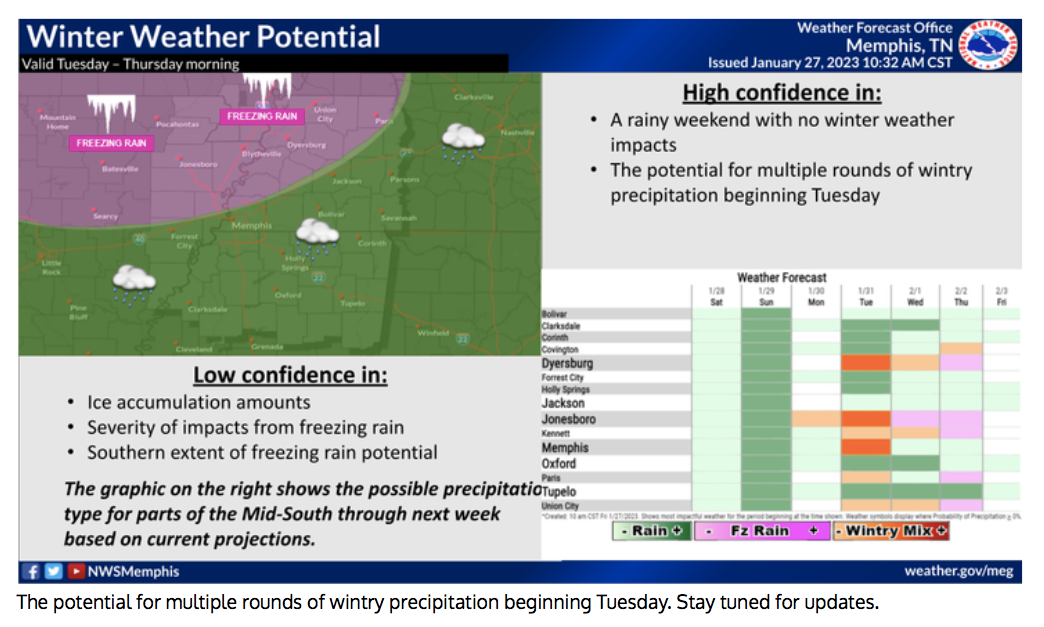
LONG TERM...
(Saturday through next Thursday)
Issued at 207 PM CST Thu Jan 26 2023

It stays dry into Saturday before the next rain systems comes in.
This will be a quick hitting system with rain leaving Sunday
night. Temperatures stay above freezing so it will just be rain.
Maybe a half inch give or take a bit. Dry Monday and then it looks
like the southern stream of the jet stream gets active. This will
mean several weather systems for our area. It predominately looks
like rain...however right now it looks like Wednesday night into
Thursday there could be some mixed precipitation...rain/snow/freezing...for
mainly locations along and north/west of I-40/65. This is many
days away so no reason to get excited. We will keep watching this
develop and the precipitation type and location will most
definitely waffle over the next couple of model runs.

It does look like it will be wet for the second half of the
extended forecast. Right now storm total QPF for Tuesday through
Thursday night is 1.5" to 3".
-
Just now, Carvers Gap said:
Yeah.....Happy hour is here.
Lets keep in mind that it is just one run out of many. So much more to life than to hang out hats on one run lol
-
33 minutes ago, Carvers Gap said:
I suspect we have at least one NWS poster on our forum. They are an excellent poster. And that is a great catch. I think that shows that what we talk about here isn't sunshine pumping or the like. That window is a legit window for winter weather. Where is the question? Nina winters often favor middle and west TN, and this potential overrunning event signal favors those areas, though I wouldn't rule out E TN by any means . Those crappy decades of winters Nashville had prior to this recent good run....chocked full of Nino winters from the early 90s onward. During the last decade, we have seen more Nina winters. Another good trend during the past couple of winters is the return of the -NAO. That helps. We have seen what January looks like w/out Atlantic blocking. Many Kocin storms have -NAOs as part of the equation.
All of that said, the trend overnight was to bring that frozen boundary from the Ohio River into Central KY. In some cases, the heaviest bands were brought completely to the KY/TN border, including SW Virginia. The Euro ended w/ an extensive Miller B hybrid. So great find and great disco by Nashville. I agree with all of that. We really want to see an aggressive trend southward so that the boundary gets south of us...so that the inevitable northward jog will still leave us w/ frozen precip. I am 50/50 on whether modeling is just sensing the cold, and pushes that boundary further southward.
The GFS is less aggressive(though 6z trended significantly colder) w/ the boundary pressing southward. The 0z CMC would bring most of TN into the mix north of I-40 in terms of ice. The 0z Euro is in between the two, and is a nice compromise for now. There is still plenty of time for this to move around(roughly 48 hours before this begins to lock in). The Euro late in the run has me intrigued as it has had a real tendency to trend west with storms(think inland runner which trended to Illinois). I think we want any storm on that model on the coast or just off the coast...at this range.
I have said it before but will say it again, do not wish ice on anyone anyplace! But the pattern next weeks looks just like what I recall from 1994. In addition, I would not want to be in the shoes of the NWS or local forecasters going into next week, just going to be a tough tough call likely two with a day or two of the event unfolding as to what to expect, where, and how much
-
4
-
-
Good discussion on the long range from the Nashville NWS - have they been trolling the weather forum? Sounds like what we have been discussing
LONG TERM...
(Friday Night through next Thursday)
Issued at 225 AM CST Thu Jan 26 2023

Our extremely active weather pattern will go into full throttle
over the weekend into next week as upper level winds become
southwesterly and an Arctic cold front stalls across the region
on Monday. Prior to then, another wave of low pressure is
forecast to develop across Texas on Saturday then race eastward
along the Gulf Coast into Sunday. After a mild and dry day on
Saturday with lows in the 30s and highs in the 50s, rain will
return to the midstate and continue most of Sunday before ending
Sunday night. Although this system will be weaker than the one we
saw yesterday, the longer duration of rain should allow most
locations to receive a half inch to an inch of rain.

A forecast nightmare begins Monday and continues the rest of next
week as an Arctic cold front moves across Middle Tennessee and
stalls. Front then looks to waffle back and forth near us for
many days as numerous shortwaves pass overhead. Models are not
surprisingly really struggling with this pattern and exactly
where the front will end up day to day, with each model run
showing drastic changes from the previous one. However, overall
this looks to be a very wet pattern for us with several inches of
rain possible. In addition, if the front pushes far enough to the
south of the midstate, colder air filtering in from the north
could lead to a wintry mix of rain, freezing rain, or snow -
especially across our northwest counties. Latest NBM keeps us
mild enough for just rain until Wednesday and Thursday when
freezing rain and snow probabilities increase in our northwest.
Due to the unusually high uncertainty in the extended forecast,
have kept temperatures, precip chances, and precip types near the
NBM, but it should be noted the forecast confidence next week is
very low.

&&
-
2
-
-
1 hour ago, Carvers Gap said:
Looks like some light snow showers or flurries will be moving along the TN/KY border this morning. One line is coming off the Plateau and one line is moving onto the eastern rim.
Yea went through a grapple shower on I-65 south just coming into Nashvegas this morning
-
4 hours ago, snowmaker said:
Can’t wait to see what that Canadian run produced. That 31st-2nd Period looked like a nasty looking winter storm for Tennessee on this run. 0z gfs is a colder run through the 2nd but most frozen looks to be in Kentucky most of the duration. But it did trend colder in that timeframe but warms up quite a bit as the run goes. It will be interesting to see the ensembles of all modeling tomorrow.
Produced a 1994 esq ice storm not good if you enjoy electricity.
-
2 minutes ago, Matthew70 said:
Unbelievable how the GFS is so bi polar.
The unbelievable part is that it is used by so many forecasters
-
2
-
-
10 minutes ago, Carvers Gap said:
I don't even know about trends at this point. I am just looking to see where the general track cone is, and that the storm signal is still there. I would think by Saturday, we will have a very good idea of where this is headed. I, and some others, follow a general rule that we have to get a threat inside 150 hours to really track it. Models are decently good enough now that sometimes we can track out to day7-9, but that has its pitfalls as we have all seen. This is tricky business where very cold air is trying to undercut a weak HP at 500mb. The axis is shifting hundreds of miles right now due to projections of the SER, the strength of the cold air, and number of short waves which drive the boundary. Pretty big cone right now. That cone decreases with each run. Kind of like March Madness, we want to survive and advance. For much of January, we have been in the NIT. This is a legit pattern right now, so we just want to stay in the game with each passing model suite until this narrows the cone.
Yea, there are so many players that make up any one storm it is amazing
-
1
-
-
2 minutes ago, Carvers Gap said:
So what is the difference between the control and deterministic runs?......The storms which are bigger appear to hold the energy back long enough for the cold to drive into the forum area. When they precip is quicker, it is more cold chasing rain. When that energy holds back, it gets nasty. It may also be that the cold front is stronger.
So we are still looking at general trends here, none of this set in stone until at least early next week
-
The icing depictions on various models are unnerving to say the least.
-
1
-
-
1 minute ago, John1122 said:
Here's how bad the GFS is with long range modeling.
00z last night we barely got above freezing from 144-300+. Tonight we don't get below freezing from 114 to 300+. The 1990 analog would be strong again if it's remotely right tonight, except this January will finish warmer than 1990.
Yea, its is a real head scratcher as to why we keep this piece of shi-.
-
1
-
-
36 minutes ago, snowmaker said:
12Gfs storms not there and temps are warmer around the first week of feb than before. Of course it will change. Maybe it will come back. Just hope the can kicking isn’t starting again. Looking for something to show up on modeling and stick. This storm to our northwest has been there for over a week and hasn’t hardly budged.
Never fear, the happy hour run will be different yet again!
-
Just now, TellicoWx said:
Nothing like 2" of freezing rain and a foot of snow...Goofy rides again
That is crazy! You know that will be all over social media lol
-
1
-
-
Is that another low coming out of the gulf? Wow the eye candy
-
2
-
-
4 minutes ago, Carvers Gap said:
18z GFS is a nice run so far to echo Silas.
Easily going negative - someone is getting hit next week
-
4
-
-
I think safe to say that something is going to happen next week!
-
2 minutes ago, Carvers Gap said:
IMHO, we are seeing the signal for an overrunning event. It could be the Ohio River. It could be the mid-shot from Jackson, MS, to Atlanta, GA(see 0z GFS)...or it could be this forum area. But a potential cold, Arctic boundary could be interesting w/ an active STJ. That is about all we know right now. It could all dump West, but modeling has been constantly pushing cold highs underneath that 500 SER, and you are right....that is the recipe for ice/snow in the upper south.
Well, been stated before in the forum but at least we have something to track this year, many years it is just one rain storm after another.
-
1
-
February 2023 Medium/Long Range Pattern Discussion Thread.....Torch or Tundra???
in Tennessee Valley
Posted
Yea i believe it