

matt9697
-
Posts
274 -
Joined
-
Last visited
Content Type
Profiles
Blogs
Forums
American Weather
Media Demo
Store
Gallery
Posts posted by matt9697
-
-
8 minutes ago, Holston_River_Rambler said:
12z NAM goes full on Miller B with bit of lp running up through the foothills of the Apps.
That looks convoluted to me and seems different from what other models are showing, snow to rain to snow for Middle TN area
-
30 minutes ago, jaxjagman said:
LONG TERM...
(Monday Night through next Sunday)
Issued at 111 AM CST Sun Feb 16 2025

For the long term, we shift our focus to the next system that will
likely bring some accumulating snowfall to middle TN Wednesday. The
current NBM probabilities of at least 2 inches or more of snow is
40% south of I-40, and between 60-80% north of I-40. The
probability of 4 inches or more is 50-70% north of I-40. Sampling
a few model soundings from both the NAM and the GFS, temperature
profiles are well below freezing with ample moisture in the
dendritic growth zone, so as of now, this looks to be an all snow
event. As the trough exits off to the east Thursday, bitterly cold
temperatures will settle in at the surface as high pressure
builds in from the midwest. We will remain dry through the
remainder of the forecast period, but again, it will be cold.
Current high temperature forecast has the majority of middle TN
aside from the far southern counties below freezing for 48+ hours
for Wednesday-Thursday. Some slight warming will occur Saturday
and Sunday as upper level ridging builds over the Ohio River
Valley with temperatures getting back into the 40s.
Not to jinx this but I think I am in a good place for this system.
-
36 minutes ago, Holston_River_Rambler said:
Here are most of the 6z accumulation maps:


Thank you; this should be coming into better focus the next couple of days; the mets on local TV in Nashville are including the threat of a plowable snowfall in their statements this am.
-
Where are the accumulation maps?
-
23 minutes ago, Carvers Gap said:
Brutal stuff given that we had record highs to start the month. Big flip. The difference between our max temp for the month and our min could be extreme. Some areas my flirt with 75-90 degree differences in those.
This winter has already been one for the records for my household - we may burn a full rick of wood for the season - end of last week I started on my fourth rick and looks like I will get into the fifth before the end of March
-
 2
2
-
-
Just now, Matthew70 said:
It appears the worse of the flooding is setting up right along I40 including Nashville. Very concerning the amount of rain coming down there. This could get very ugly & life threatening quickly if it stays over that area. Luckily here in Murfreesboro we are just on the edge of it.
Yes, it likely will, I am under a flood advisory; concerning is the red bow cell to the southwest of Sumner county moving this direction, that will likely put us in a flood warning.
-
 2
2
-
-
I am amazed at the level of cold projected next week, even without any snow. I was real close to pulling the Team Spring cord this week with all this rain.
-
2
-
-
We have already picked up .81" and it looks fairly solid back to the west; before sunrise, judging by what the creek sounds like near me, all of that .81" has run off no telling what things will look like by the end of the day. I would say we would be primed for power outages if we get any wind with the storms later this evening.
-
It appears to be a highly complex pattern for next week to say the least; could get very cold for those areas that put snow on the ground.
-
1
-
-
Just now, Carvers Gap said:
We don't want that push. We want a west-to-east confluence over our area w/ the STJ just ripping. The GFS is very cold at the end of its run. One cutter, and we could be well below zero.
Exactly, that is what concerns me, that boundary is just about in the right place for the forum area; realistically, this is one solution in what will be many, many more over the next 10 days but hoping we see this same solution on Feb 11~ give or take!
-
58 minutes ago, John1122 said:
The models are looking second half of February 2015ish right now. But the epic cold is looming to our NW and doesn't quite get all the way here.
That is so uncanny, I remember that February was planning a blow out party for my mothers 75th birthday and was concerned about travel for everyone; now I am planning her 85th and doing the same thing!
-
3
-
-
10 minutes ago, Carvers Gap said:
Boundary has been trending south on modeling. Reminds me a lot of the "no way it is gonna snow in Tallahassee" storm where it just kept sagging further and further south. Good trends. The CMC looked loaded for bear at the end of its run. That cold means business.
Seems like it but it doesnt look like it has the same "push" as the cold did earlier in the season. Either way that was a screensaver run of the GFS and it looked like it had another storm incoming at the end of the run.
-
3
-
-
8 hours ago, John1122 said:
Severe winter storm for a lot of the forum area on this GFS run. Epic freezing rain in my area. Heavy snow western areas and Kentucky.
Insane with 2.5+ inches of freezing rain Plateau, SE Kentucky and SW Virginia. 2 feet of snow in Eastern Kentucky. The model maxes out at 2.5 inches of freezing rain but it appears that 3+ qpf falls.
It's inside 10 days when it starts now. The boundary stalls and floods, then creeps south and give the incredible ice totals.
Then it loads up and does it again.
8-12 inches of snow in Western areas.
That freezing rain would be off the charts, glad to see that it was not as bad on the latest run but that would be catastrophic!
-
 1
1
-
-
After this week, alot of people, myself included, will have a real case of Spring fever!
-
3
-
-
1 hour ago, Holston_River_Rambler said:
0z AIFS looks good again as well. Might poke around ensemble member charts later.
Yea, it seems to echo the replenishment of ground water for sure, I would be surprised if we didnt sneak another snowfall or two out before mid March.
-
 1
1
-
-
1 hour ago, Holston_River_Rambler said:
0z Euro shows a possible way to score at the end of its run. Successive waves push the boundary further south. Something we've been talking about as well as seen before when the Pac is less than favorable.
I don't really even know what the 6z GFS was on. Looking at the precip panels I thought it must have been trying to build a big NAO, since systems tried to cut and got shunted SE:
There's sort of a consistent 50/50, but most of the big blocking is in the PAC
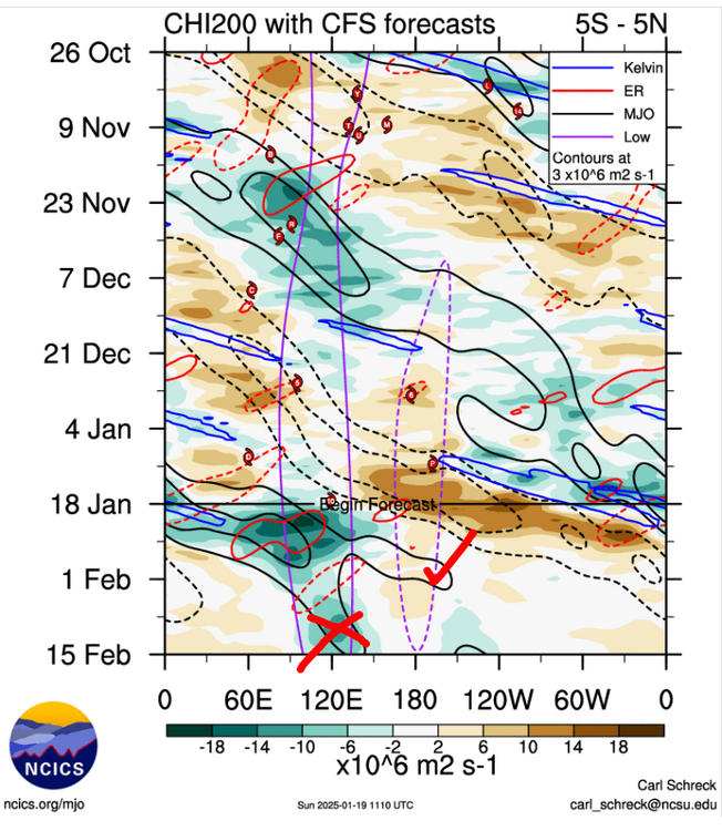
Further afield, the Indian Ocean is lit up. In fact everything from 3-6 in the RMM plots look healthy and I suspect that's why the RMM plots are killing the signal into the COD. Having so much in each section kind of balances everything out:

Might be good if that strong of a signal with convection on both sides of the equator can make it around for another pass into 8-1. I still think it is at least 3 weeks before what is no south of Sri Lanka makes it anywhere close to being favorable for us.
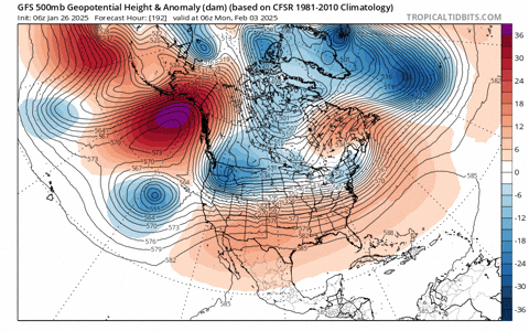
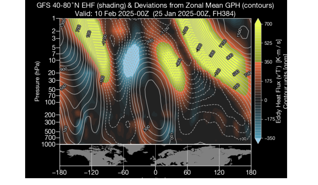
Up north, a lil split, a lil warming on the Euro:


GFS has more warming but nothing like the Euro's split above.
The old yin - yang pattern:

Not so much reflected in height anomalies:

Seems to have some connection to the blocking over the Aleutians:

Waaaayyyy out there, but something to watch. Sometimes in La Ninas lately we've seen MC convection enhance Central Pac blocking and help with a strat split/ warming. If we could get one around Feb 20 or so it might not screw us over too much, especially with a N hemisphere base state this winter that leans cold over N America.
Here's another visualization of the GFS temp anomalies above, paired with ye olden 200 mb divergent winds:
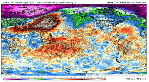
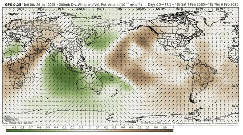
200 mb divergent winds show where there is upper level divergence and thus lift/ t-storms associated with the MJO. In fact and TBH, I don't really know what a CHI anomaly is, I just call the right hand chart above the MJO forecast chart.
While I'm trying to wake up let's see if we have any mountain torques too, cause why not. GFS tries to drop a Siberian high down into East China towards the end of its run, but ehhh that's about it.
Guess this means I am crazy but am I the only one that sees Munchs, The Scream here? Is that a harbinger of the upcoming pattern?


-
3
-
 11
11
-
-
Looks like the southern stream is getting more active in the long term, maybe we can start replenishing the ground water without having flooding!
-
1
-
-
One of the local mets just posted that this is the only time since 1977 that Nashville has recorded all the morning lows thus far in January at or below 35 and only the fourth time in Nashville weather records which date back to 1875; pretty remarkable.
-
6
-
 1
1
-
-
I still think we get another forum wide storm before winter is over; most years, at this point, we havent had anything to track and are looking to February, heck, we have all had at least some snow, so whatever we get in February is icing to me.
-
6
-
-
31 minutes ago, Jed33 said:
I will say that in Volume 1 there is a chapter dedicated to the South, but it is quite small compared to the Northeast and New England sections.
Probably because the South was sparsely populated compared to the Northeast and New England areas, fewer observations, would think our weather could have been similar
-
1
-
1
-
-
5 minutes ago, Jed33 said:
I found a copy of Ludlum’s Early American Winter’s Volume 1 last year on Amazon. It cost me about $100, and at the time they had 5 copies. I am truly amazed at what’s in it!
Oh wow, yea, it is out of print and hard to come by but it is amazing what those early settlers had to live through!
-
1
-
-
14 minutes ago, Save the itchy algae! said:
Springs have gotten cooler in my 10 years here the last few, there’s no doubt. But it’s a small sample size.
.It is interesting to me that in my location, we have had snow at some point during the last three Januarys, which, while none of them were really extreme, does stand out in my mind just because of the consecutive nature when not too long ago we would go multiple seasons without any measurable snow. The Earth is impacted more than we realize by the sun. During the tail end of what is known as the Maunder Minimum, things happened, such as the extreme winters of Valley Forge and the fact that just a few years later, early settlers of Donelson and Robertson led a group across the frozen Cumberland River to found what would become Nashville. Now, according to some, we are headed into another solar minimum. Is this the start, or is it just a fluke? Another great resource, if I could ever find some in print, would be the volumes pinned by David Ludlum, Early American Winters, where he chronicles early American Weather, but it is and likely will remain out of print.
https://pmc.ncbi.nlm.nih.gov/articles/PMC7575229/
https://www.nashville.gov/departments/parks/historic-sites/fort-nashborough
-
18 hours ago, jaxjagman said:
Why couldnt you?Think the MJO becomes murky right now where it actually could go in later days,probably any model could be right ATM into the extended period.I was looking at the CFS and it shows two camps in the upcoming days,,believe it should be more advanced.Seems to me the IO will play games with the signal from the Rossby wave trains and Kelvin,thats just my thoughts,no forecast and i certainly could be wrong
I am ready to break for Spring personally! I have had to have a fire for the past four weeks, I am tired of wood and cleaning the stove, but never tired of the heat, nothing heats like a good old fashioned wood stove!
-
3
-
-
10 minutes ago, Holston_River_Rambler said:
We need some obs from eastern KY folks. NWS Jackson is talking dirty about deformation zones, baroclinic leaves, and snow squalls. Might even hit BuCo
Yea that area looks covered up with darker banding, ours has totally lightened up at this time
-
1
-


Winter 2024/2025 February Thread
in Tennessee Valley
Posted
Although I wanted at least one significant snowfall in my backyard, I am not complaining. For the fourth year in the 2020s, we have had measurable snow, a far cry from the 2010s, when we would go multiple consecutive seasons without snow of any amount. Hopefully, the trend will continue for the next few years! I am ready for Spring; I have alot of things that need to be moved around regarding landscaping and would like to get started, but I want to be sure we are into Spring and not into false Spring!