

AChilders
-
Posts
48 -
Joined
-
Last visited
Content Type
Profiles
Blogs
Forums
American Weather
Media Demo
Store
Gallery
Posts posted by AChilders
-
-
18 minutes ago, Roger Smith said:
Just starting to cross the warmer core of Gulf stream, I would say Nicole reaches at least low end cat-2 at some point tonight, possibly mid-range cat-2, and also performs more of a curve north than model consensus, earlier was asking people what they thought of a grazing coastal track, possibly some inland movement now probable, but I think Nicole will try to stay over warm water as long as it can, could mean a landfall Jupiter to Melbourne. Never all that far inland, heads up NNW with enough of circulation over water to retain cat-1 intensity for quite a while, strong TS near Georgia coast in 36-42h. Long duration fetch means storm surge issues must be taken very seriously. This is now almost as strong as Sandy approaching NJ and Staten Island comes to mind. Were not the storm surge forecasts lowballed there? Or did people not take accurate warnings seriously? One or other as I recall.
While this isn't close to Sandy in size or strength, I do think with the duration and size of the wind field that the surge is being under forecasted. There could definitely be areas that see 6-8' of storm surge.
-
 1
1
-
-
Has anyone calculated the IKE for Nicole?
-
3 minutes ago, Ed, snow and hurricane fan said:
HWRF has landfall near the Space Coast as a 963 mb tropical storm.
How large is the TS wind field at that point?
-
I think due to the size of the wind field that the storm surge in NE FL is being underestimated, 4 days of fetch coming onshore through multiple tide cycles during a "Beaver Tide" will push more water up the St Johns than anticipated, I feel it will be as high or higher than Irma in 2017.
-
14 minutes ago, olafminesaw said:
The Euro seems to really broaden the wind-field, without increasing max wind speed. Has a massive area of 35-45 mph winds, but probably would be a 50 mph landfall
.thumb.png.2009958a205e2c50e92e8f2390a110ea.png)
-
991 Landfall at around Hobe Sound
-
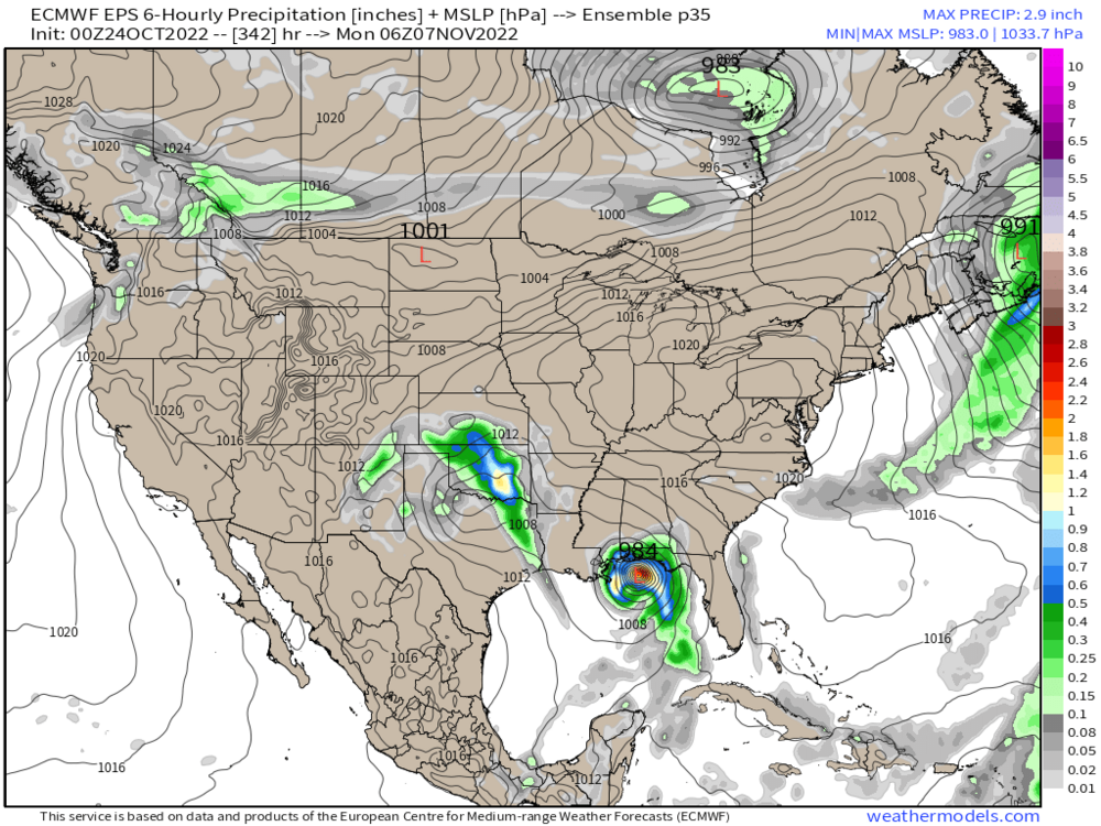
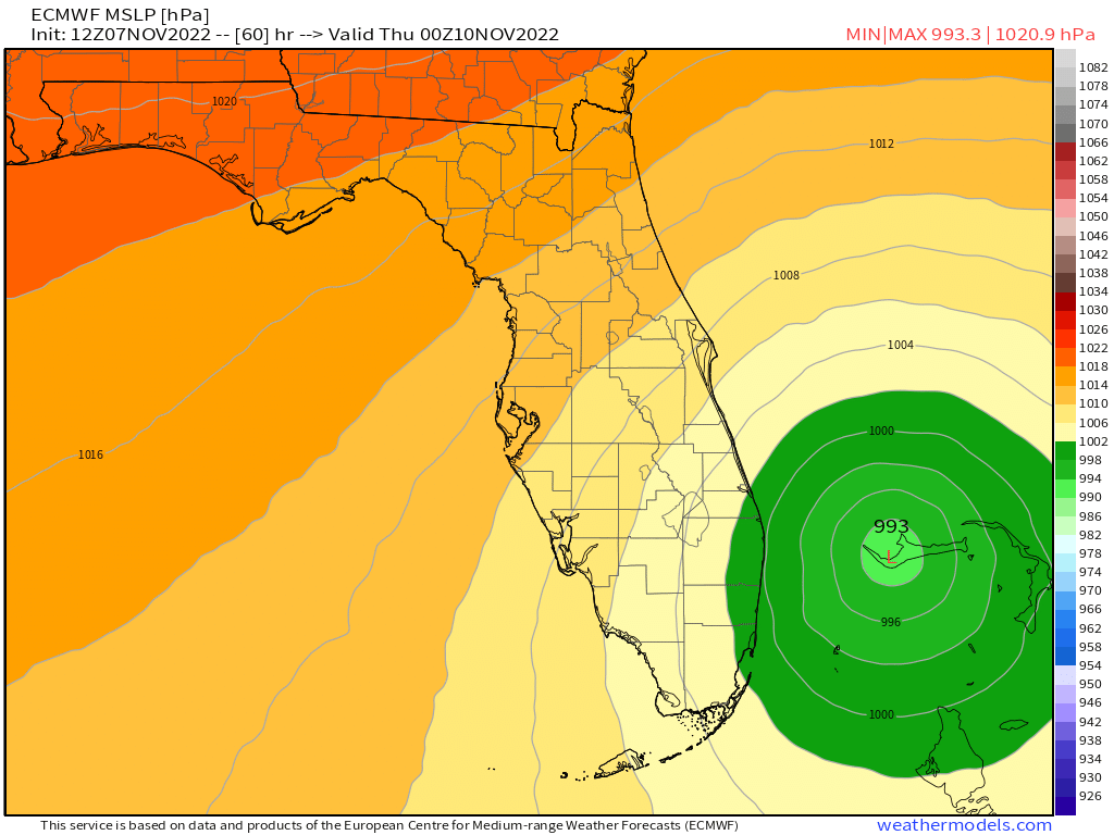
Euro coming in stronger, 995 at 48 hours
edit, 993 at 60

-
1
-
-
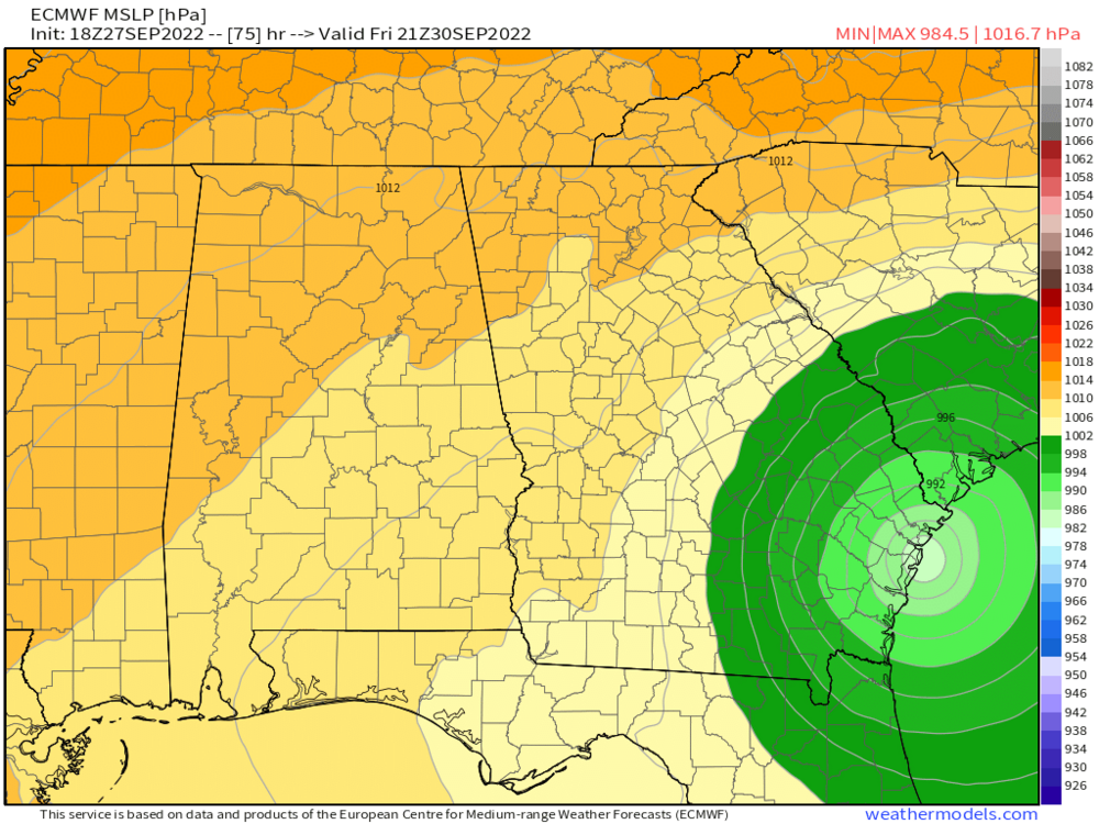
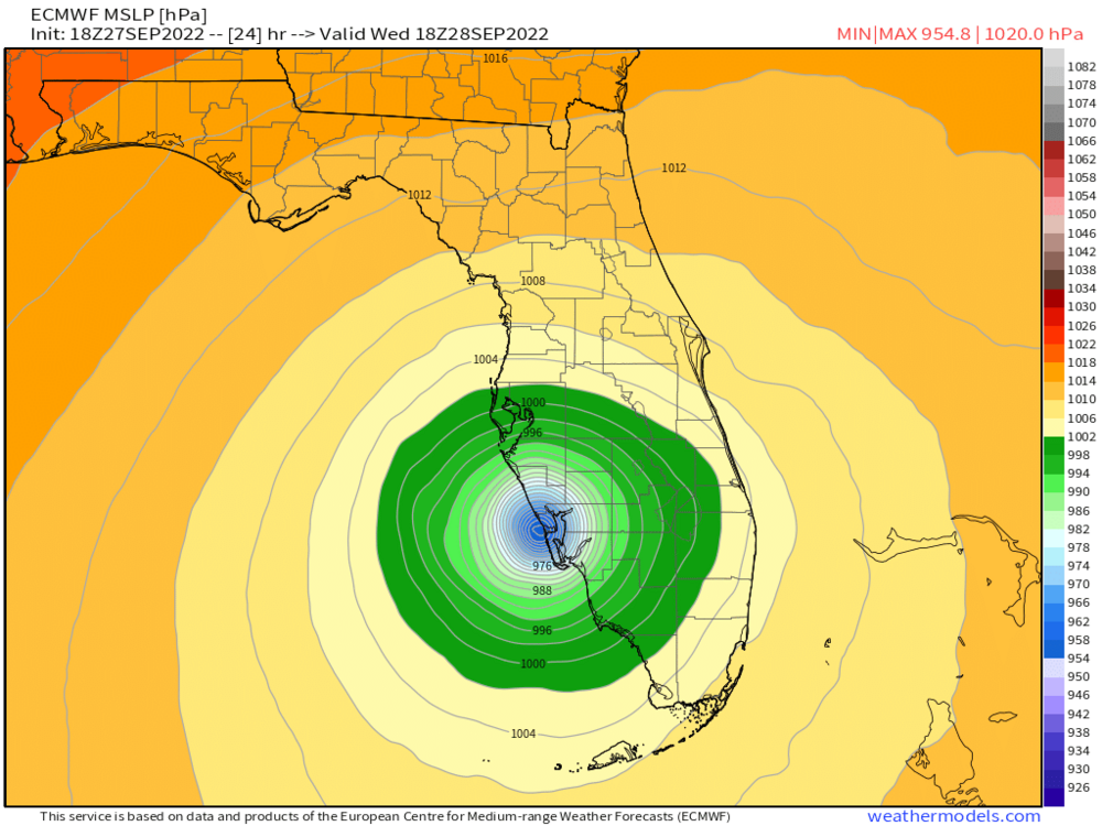
833
WTNT42 KNHC 071458
TCDAT2

Subtropical Storm Nicole Discussion Number   2
NWS National Hurricane Center Miami FL       AL172022
1100 AM AST Mon Nov 07 2022

The structure of Nicole this morning remains distinctly subtropical,
as the low-level circulation remains tangled up with an elongated
upper-level low. The wind-field also remains quite broad, with data
from the NOAA-P3 Hurricane Hunters this morning showing the highest
winds remaining displaced well away from the center. The initial
intensity is being held at 40 kt for this advisory which is
supported by the subtropical classification of ST2.5/35-40 kt from
TAFB, the earlier scatterometer data, and recent SFMR winds from the
NOAA-P3 aircraft in the 40-kt range.

Nicole might be starting to take a northwestward turn this morning,
with the estimated motion at 320/8 kt. A continued northwestward
motion is expected through the day, though there might be some
wobbles more north or west here and there as the low-level
circulation continues to interact with the decaying upper-level low.
After 24 hours, an anomalously strong mid-level ridge is expected to
amplify over the southeastern U.S. which is expected to steer Nicole
and result in the system turning westward or even west-southwestward
on Tuesday night into Wednesday. This ridging will then re-position
itself to the northeast of Nicole by Thursday and Friday which is
expected to allow the cyclone to begin gaining latitude after it
moves across the Florida Peninsula, though how quickly this occurs
is a source of track uncertainty in this time frame. Finally a broad
mid-latitude trough is forecast to eject out of the Rockies into the
Great Lakes region, further eroding the ridge and allowing Nicole to
recurve by the end of the forecast period. The track guidance is
fairly tightly clustered for the first 60 hours of the forecast,
though it has taken a noticeable shift southward this cycle, and the
NHC track forecast was shifted a bit southward due to this
adjustment, but still is a bit north of the HFIP Corrected Consensus
Approach (HCCA).

Intensity wise, Nicole may take some time to consolidate given its
large radius of maximum winds and currently meager central
convection due to nearby dry air related to the nearby upper-level
low. This feature should gradually decay and warm 27-28 C
sea-surface temperatures should enable more organized convection to
develop while the system remains in a low vertical wind shear
environment. Nicole is forecast to transition to a tropical storm
sometime in the 24-36 hour period as this convection helps to
contract the radius of maximum wind, with further intensification
expected thereafter. The intensity guidance was a bit higher this
cycle, and the latest forecast now takes Nicole to a 65-kt hurricane
in 60 hours, which is close to the latest HCCA, HMON, and SHIPS
guidance. After Nicole moves inland, weakening is anticipated, and
the region that Nicole is forecast to emerge off in the northern
Gulf of Mexico has cooler SSTs that likely would not support robust
reintensification. Regardless on the ultimate intensity of Nicole,
the storm's large size due to an enhanced pressure gradient north of
the storm will likely cause significant wind, storm surge, and
rainfall impacts over a large portion of the northwestern Bahamas,
Florida, and the southeastern coast of the United States during much
of the upcoming week.

Key Messages:

1. Hurricane conditions are possible across portions of the
northwestern Bahamas and southeast to east-central Florida
beginning Wednesday, where a Hurricane Watch has been issued.
Tropical storm conditions are possible in the Tropical Storm Watch
areas in Florida and Georgia beginning Wednesday.

2. A dangerous storm surge is possible across portions of the
northwestern Bahamas, much of the east coast of Florida and portions
of coastal Georgia.  A Storm Surge Watch has been issued for most of
the east coast of Florida and portions of coastal Georgia.

3. Do not focus on the exact track of Nicole since it is expected
to be a large storm with hazards extending well to the north of the
center, and outside of the cone, and affect much of the Florida
peninsula and portions of the southeast U.S.

4. Nicole will produce heavy rainfall by Wednesday night and
Thursday across the Florida Peninsula. Flash and urban flooding will
be possible across portions of the Florida Peninsula along with
river rises on portions of the St. Johns River.


FORECAST POSITIONS AND MAX WINDS

INIT  07/1500Z 26.2N  69.4W   40 KT  45 MPH...SUBTROPICAL STORM
 12H  08/0000Z 27.0N  70.5W   40 KT  45 MPH...SUBTROPICAL STORM
 24H  08/1200Z 27.7N  71.9W   45 KT  50 MPH...SUBTROPICAL STORM
 36H  09/0000Z 27.6N  74.1W   55 KT  65 MPH...TROPICAL STORM
 48H  09/1200Z 26.9N  76.5W   60 KT  70 MPH
 60H  10/0000Z 26.6N  78.7W   65 KT  75 MPH
 72H  10/1200Z 27.3N  81.2W   50 KT  60 MPH
 96H  11/1200Z 29.4N  83.9W   45 KT  50 MPH
120H  12/1200Z 33.3N  79.0W   45 KT  50 MPH...INLAND

$$
Forecaster Papin/Brown
-
NHC now predicting this to attain hurricane status
-
Average intensity seems down this morning across models, but also further south approach and swing into the gulf seem to be very plausible
-
1
-
-
Only 2 of the 50 Euro members have formation of any type in the Caribbean
-
11 hours ago, Floydbuster said:
Three runs in a row of the GFS model showing a monster hurricane near Puerto Rico first week of November, similar to Lenny 1999.
Make that 4 runs in a row
-
1
-
-
3 hours ago, Ed, snow and hurricane fan said:
After Allison 2001, FEMA was in my neighborhood (came to my house) and others, following the freshwater floods, and FEMA and Federal Flood Insurance offered some people money in lieu of further insurance, that is, they would not re-insure people who flooded many times before. They cleared entire subdivisions near the bayous, and I think they did the same in 2017. Saltwater flooding, if the risk is that high, FEMA and Federal Flood Insurance should buy the property and leave it undeveloped. Taxpayers shouldn't subsidize building in disaster prone areas.
Its the price you pay to live in paradise, people will not give up ocean front views (or gulf front), even if they do, real estate vultures will come in and buy it all.
-
2
-
-
1 hour ago, Whineminster said:
How was that, sad? Place is just gone.
It honestly gets a little worse every day right now, traffic is obscene getting on and off Estero Island. Typically takes 3 hours to go 15 miles from Fort Myers city to FMB and 2 hours to get back off the island, debris piles are high and until they are somehow able to open the east end bridge towards Bonita Beach, it will stay that way. I was there again yesterday.
-
 1
1
-
-
17 hours ago, Amped said:
I spoke with he and Jeff Evans yesterday at a property in Fort Myers Beach.
-
4 minutes ago, jm1220 said:
The slow movement might increase the impact of the winds but the fact so much property is a few feet above sea level is what’s going to be really devastating in these places. Entire towns are literally built around canals in these places, and they’ll be under 15 feet of water.
Nothing but canals and houses.
-
2
-
-
2 minutes ago, jm1220 said:
The slow movement might increase the impact of the winds but the fact so much property is a few feet above sea level is what’s going to be really devastating in these places. Entire towns are literally built around canals in these places, and they’ll be under 15 feet of water.
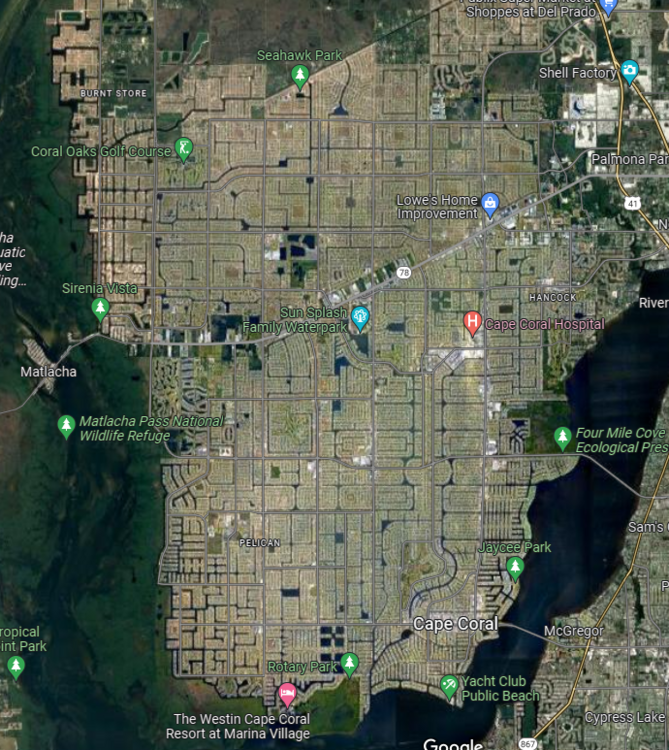
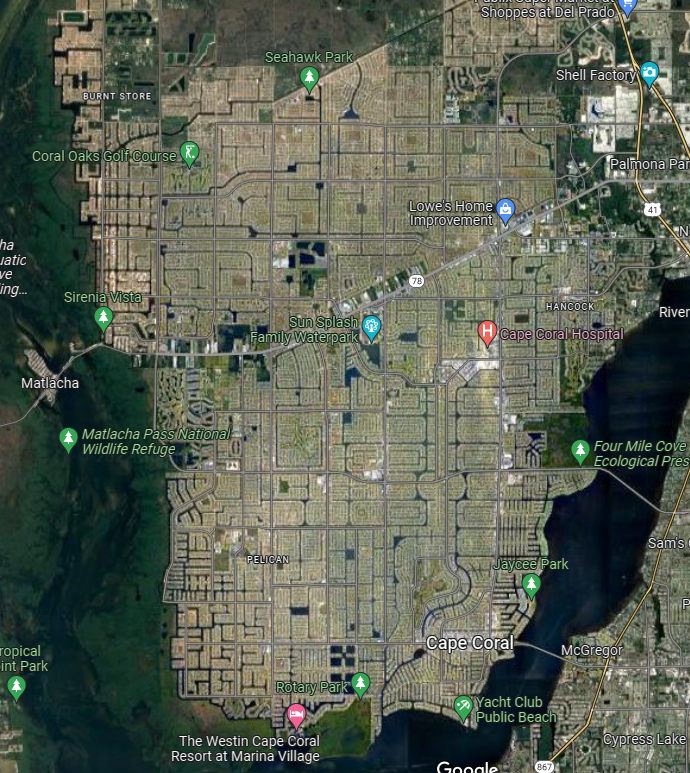
Cape Coral was designed this way, it is 3 feet above sea level.
-
1
-
-
5 minutes ago, STILL N OF PIKE said:
Anyone have the 18z euro , it should be out enough to show LF
FL and GA landfalls
-
1
-
 1
1
-
 1
1
-
-
9 minutes ago, Superstorm93 said:
Stupid amount of lightning in the northern eyewall
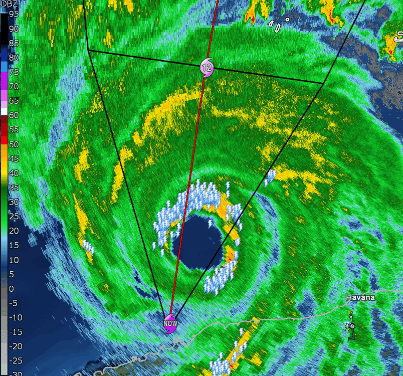
Looks like it it back on course with the NHC, just a little to the east after the earlier wobble
-
1
-
 1
1
-
-
36 minutes ago, MattPetrulli said:
That area between Sarasota and Cape Coral is a little more rural compared to the big west coast cities. Charley went that way and as we know damage was a little more limited because of that (still very costly). However, I think the wind field will be a lot bigger than Charley even though this won't come in as a 150 MPH hurricane. The lack of a big wind field led to a minimal surge with Charley (I believe around 6 feet which is crazy low for a category 4). The size of Charley was about the same as Ian is now,(according to 1 PM advisory August 13, 2004). So assuming the models are correct, the wind field SHOULD grow a lot more. That wind field can lead to really bad storm surge problems in Cape Coral and Ft Myers, which would be a difference vs Charley. So besides the hopeful Tampa miss to the west and the weakening solutions with tropical storm conditions etc, I think a potential best case scenario MAY be a landfall between those 2 cities, but either solution would be really bad. I could be a little ignorant to some aspects, so just from what I have gathered. Of course, others free to chip in.
Charley was a small diameter storm, 5 mile wide eye with a forward speed of 26 MPH, this isn't Charley,
-
1
-
-
Euro not wavering any

-
1
-
-
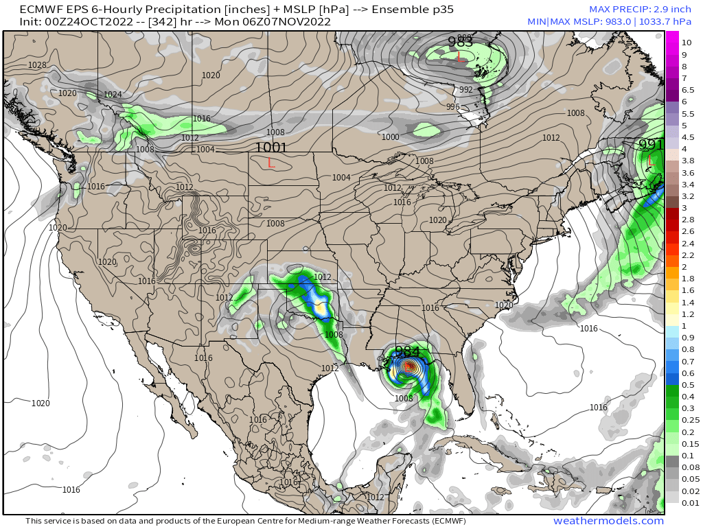
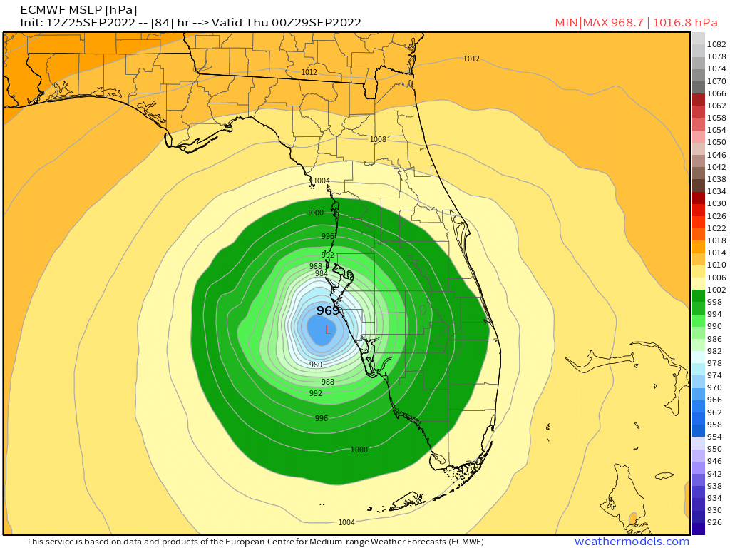
Pressure dropping on Euro at 144, high locked above, looks like its going for the 1-2 punch.
-
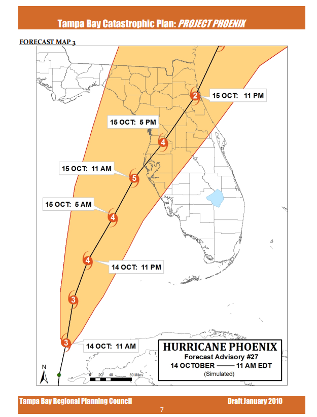
Has anyone else ever read over this before?
http://gtbacp.com/presentations/Project_Phoenix_Scenario_Info.pdf
-
1
-
-
 Was written in Jan 2010, but path looks similar.
-
1
-
.png.6f8117d2628c58240715574502f94f38.png)


Hurricane Nicole
in Tropical Headquarters
Posted
Anyone else noticing the NAM is dropping 16" of rain on the Appalachians in NC.
Tropical Depression Fred dropped a similar amount just last August on the same area.