

Double Action
-
Posts
27 -
Joined
-
Last visited
Content Type
Profiles
Blogs
Forums
American Weather
Media Demo
Store
Gallery
Posts posted by Double Action
-
-
The inner band is about to come over me here in pinellas. I’ll see what it brings. So far we have had some gusty wind nothing to write home about and the last hour heavy rain.
-
Tampa has an Indian burial ground that protects us. I have heard that and I now fully believe it.
-
 1
1
-
-
17 minutes ago, Prospero said:
Power is off!!
Hope I will be back...
Darn. I’m sure I’ll be next. BTW happy birthday. Iam new here but already feel like Iam home. Bridges are closed and police blocking travel to the beach strip as I tried to go. Still close to water and seeing some gusts. I too hope nobody gets hurt or any damage but these systems are exciting.
-
3
-
-
22 minutes ago, Dbullsfan22 said:
Outside of maybe the wind gust, could being closer to the center vs further to the East actually be a bit of a break for the TB area? Seems most of the strongest storms are further east
Unfortunately the strongest winds in this one are north in those two heavy bands around center and over water. 70 mph sustained and that’s going to hit Pinellas county and Tampa. Good news is it will be a East and SE direction so flooding less an issue but I see power outages and some damage a certainty. Dark night is coming.
-
1
-
-
Iam right on the coast next to belleair bridge. I’ll try and take some video if things get interesting.
-
1
-
 1
1
-
-
We could be seeing the enhancement going on as it interacts with that frontal boundary that was mentioned. Why do these things always hit at night.
-
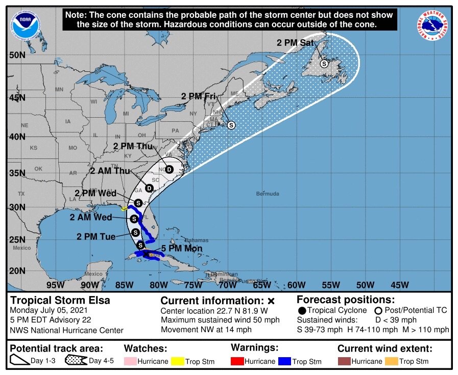
NHC nudged east. Anyone in Tampa wanting to see what a strong TS is like is going to get their wish. This one is coming closer to us than ETA and could be a direct hit.
-
1
-
-
47 minutes ago, olafminesaw said:
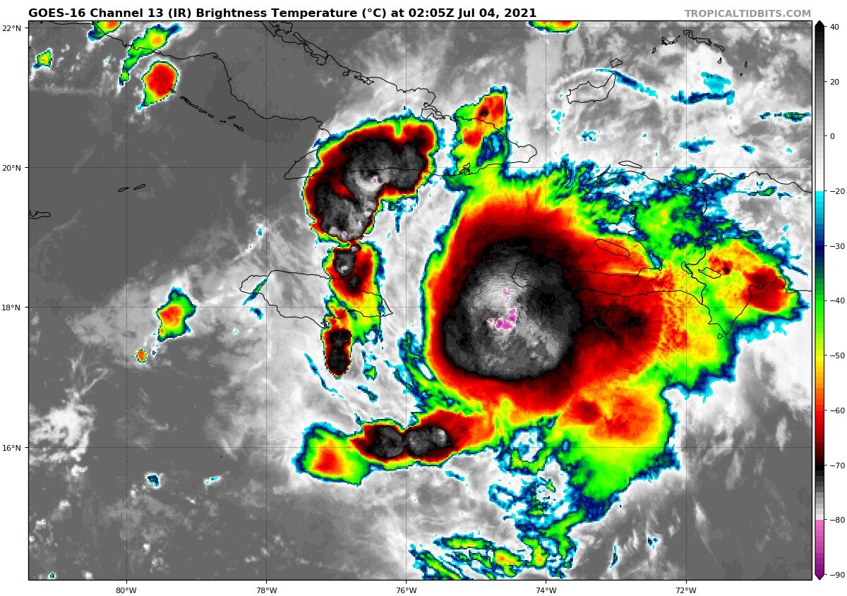
Is this the LLC?

It’s the upside down U on the left of your X
-
2
-
-
I lost power here 25 minutes ago from a lightening strike. Good news is I have a generator and it works. First real test.
-
The impact and last day of the track is going to mirror ETA. Unless of course it comes in stronger than ETA but right now looking pretty similar. There’s going to be a greater impact to south Florida though due to proximity as ETA came in from farther out.
-
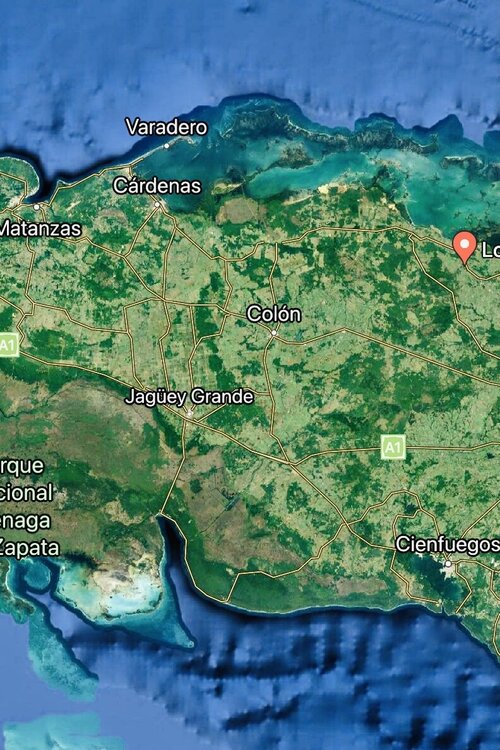
Made landfall in Cuba. Should be exiting in 4 hrs.
-
23 minutes ago, CampergirlFL said:
Eastern Hillsborough county here, between Tampa and Orlando (I-4 corridor), keeping a close eye. Trying to decide on the hurricane screens. What direction would the winds be coming from? My house faces North
.South then SE at the worst.
-
The GFS actually shows the worst possible approach to tampa. Would rather have it go right over my head. Even the NHC forecast puts us on the worst side.
-
1
-
-
Looks to be much better organized despite the westerly shear. Difference is it’s not plowing directly into it at breakneck speed. It also has picked a less hostile area to cross. The water stays exceptionally warm and deep right up to land and the mountains of Escambray are east of Cienfuegos. The only thing in the gulf to hold it back is going to be shear. Going to be interesting for sure.
-
1 hour ago, Prospero said:
I will say, over the past few years, with Tampa Bay in and out of cones now and then, I do not remember consistently being in the middle of any cone for a few days solid.
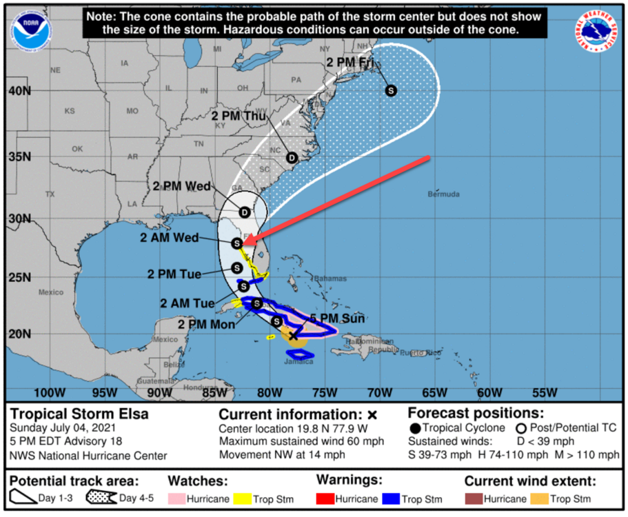
I know. I’m in Seminole and have watched these for 30 years and haven’t seen us dead aimed in the cone for this many days. Lucky this isn’t a cat3 or bigger. I would be freaking out. Even the Irma cone flip flopped but generally stayed east. Harvey freaked me out though that was the only one where the cone lasted about a day or two on us right to the end. I had the wood and screws ready but didn’t use them cause it kept nudging south on radar despite the cone not shifting.
-
1
-
-
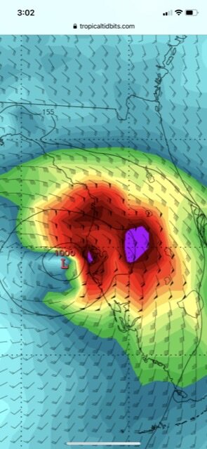
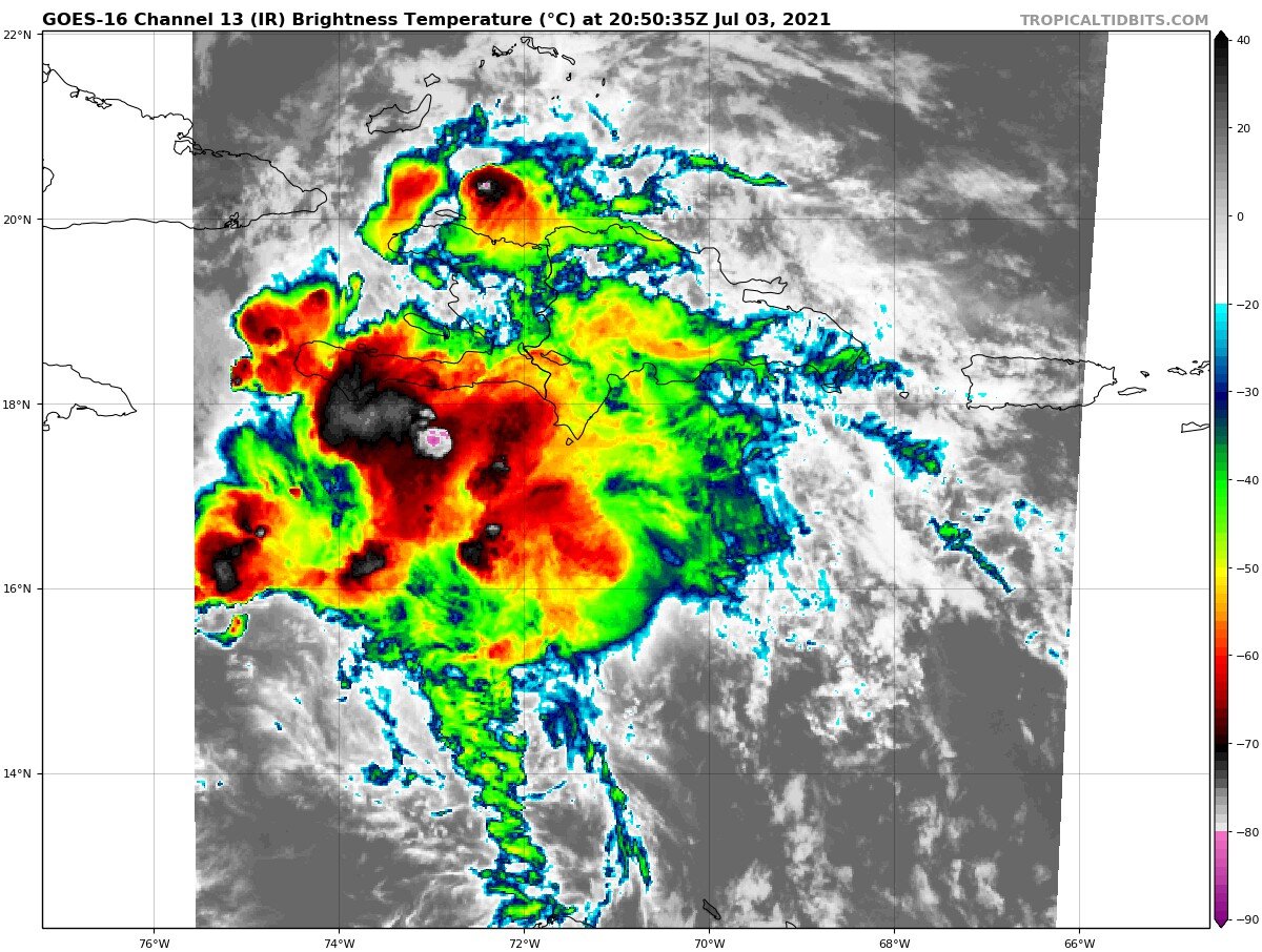
Sloppy looking tilted storm. This one couldn’t stack against the shear and would have been gone if it didn’t avoid land. The funny thing is the shear actually saved it by relocating those centers.
-
Weird that it has struggled. Plus that track was due west from where it was. Maybe it has kept relocating centers overnight. Has the shrimp look forming again.
-
18 minutes ago, Floydbuster said:
Excellent analysis. Thanks
-
My bad I didn’t see the discussion.
-
When’s the next recon? This thing is exploding right now.
-
Looks to have established an impressive outflow channel to the south now and the dry air to the west is mixing out with that new wall of convection forming. I think it closed itself off.

-
If this recent burst continues it will more likely strengthen coming into a diurnal period over deep warm water. It seems to have missed Hispaniola and looks to be slowing down some with a CDO forming.
-
That is the start of a CDO snorkel with the hot water stack on its east. Pretty cool. Question of course is this the result of less shear and maybe lessening speed. If it holds up I think the answer is yes

-
1
-
-
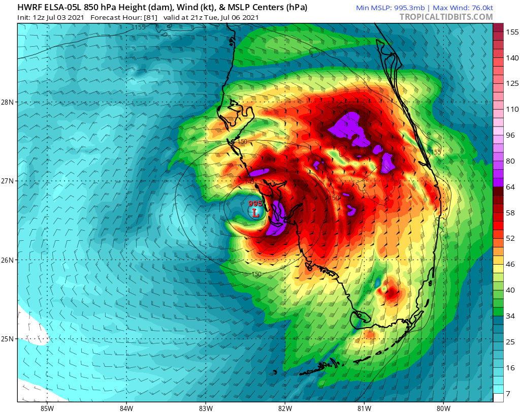
Latest model runs are in very close agreement now. HWRF came back to reality and is also on top of GFS and ECMWF. It looks like it is going to survive barely despite clipping Haiti and then traversing Cuba. Ft Myers to Tampa Bay will most likely get full tropical storm impacts. Rain for the rest of florida. I’am in Seminole fl and we have that trough on us right now with lots of rain so I expect adding this to the mix will lead to localized flooding.

-
1
-


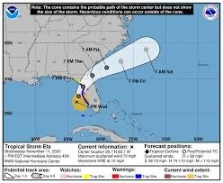
Hurricane Elsa
in Tropical Headquarters
Posted
Nothing much to report from my house. Lots of rain but that was expected. I hope people that are new to Florida don’t disregard any future warnings when a system comes in. They are all dangerous and unpredictable. We just got lucky this one succumbed to shear.