

Dick_LeBoof
-
Posts
44 -
Joined
-
Last visited
Content Type
Profiles
Blogs
Forums
American Weather
Media Demo
Store
Gallery
Everything posted by Dick_LeBoof
-

Richmond Metro/Hampton Roads Area Discussion
Dick_LeBoof replied to RIC Airport's topic in Mid Atlantic
Just following along with the radar, you can see the banding form in real time. What a treat. -
Richmond Metro/Hampton Roads Area Discussion
Dick_LeBoof replied to RIC Airport's topic in Mid Atlantic
Go clipper go! -
Richmond Metro/Hampton Roads Area Discussion
Dick_LeBoof replied to RIC Airport's topic in Mid Atlantic
some decent banding that ended up setting up here! Fun stuff. -
Richmond Metro/Hampton Roads Area Discussion
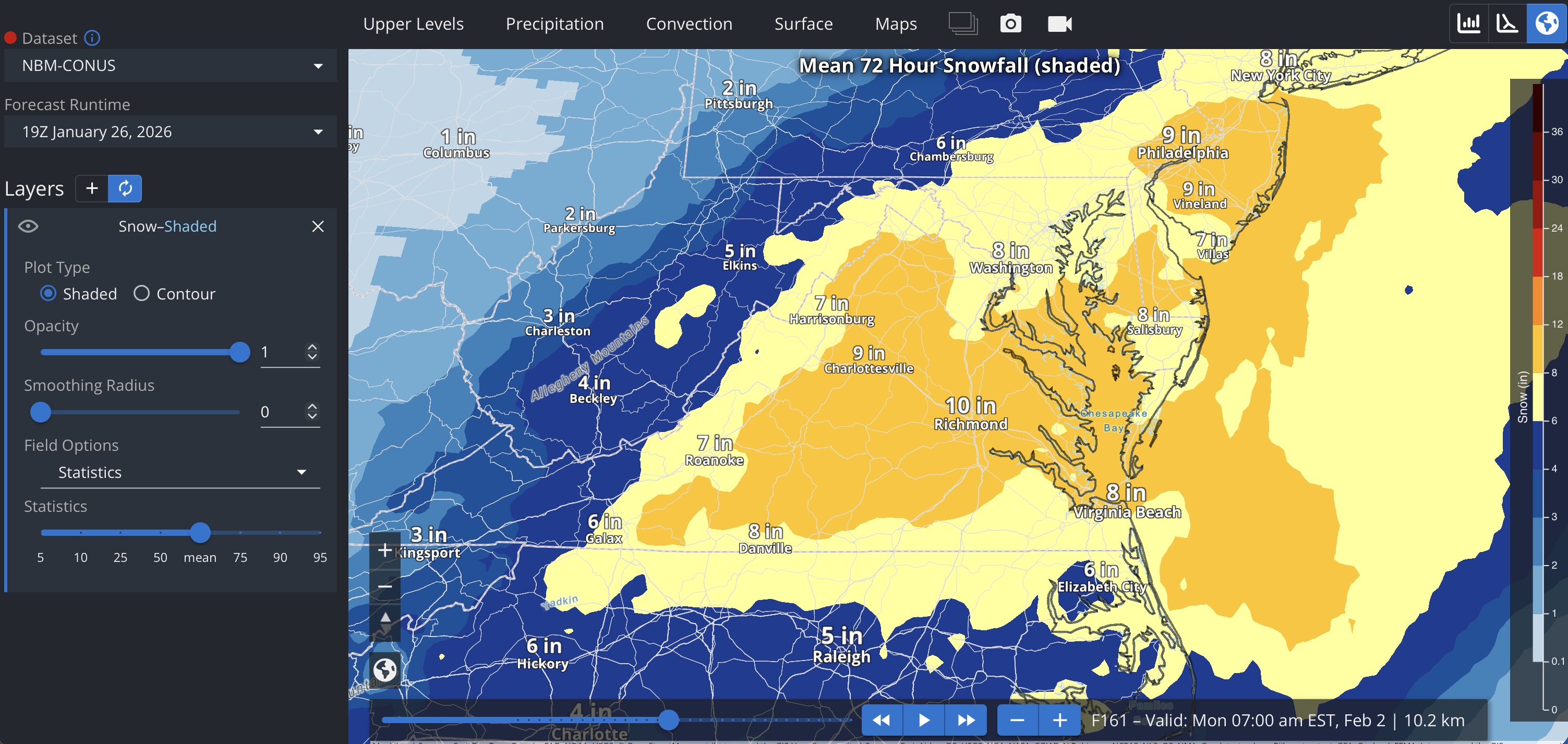
Dick_LeBoof replied to RIC Airport's topic in Mid Atlantic
Here is the observed snow total map from the Wakefield NWS office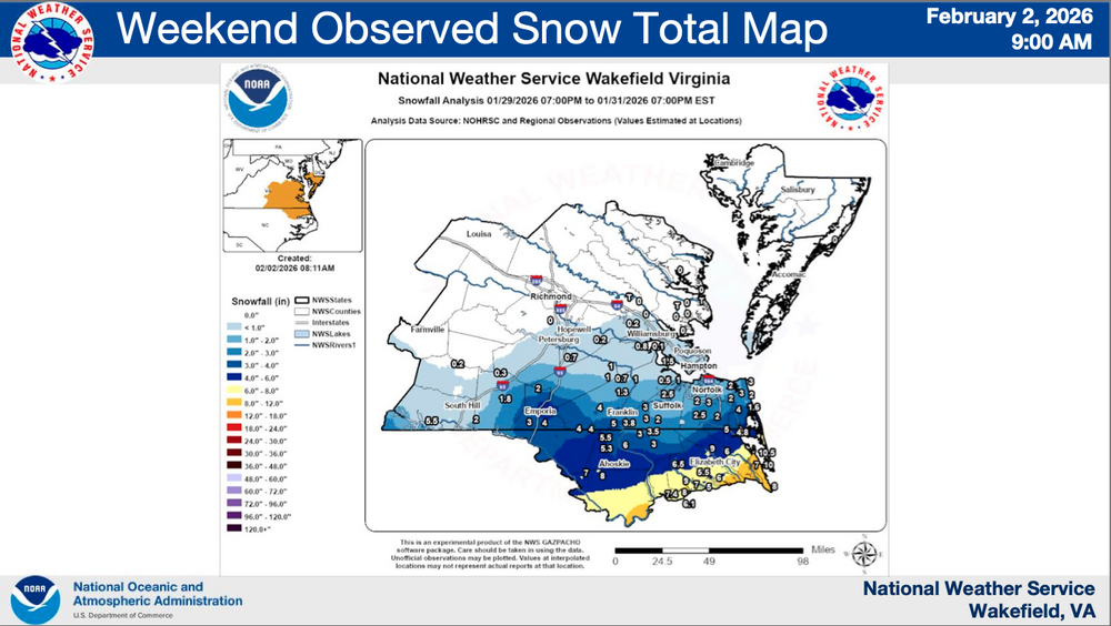
-
Richmond Metro/Hampton Roads Area Discussion
Dick_LeBoof replied to RIC Airport's topic in Mid Atlantic
"..impactful accumulations expected in areas like Richmond, VA ... " In addition to language that seems to indicate they believe the precipitation shield will be more widespread than the current suite of Global models that point to dry air intrusion suppressing snow totals. -
Richmond Metro/Hampton Roads Area Discussion
Dick_LeBoof replied to RIC Airport's topic in Mid Atlantic
Whoa that's a big update for Richmond! Is the WPC a national-level group? -
Richmond Metro/Hampton Roads Area Discussion
Dick_LeBoof replied to RIC Airport's topic in Mid Atlantic
I assume this doesn't take into account the latest 18Z euro run? -
Richmond Metro/Hampton Roads Area Discussion
Dick_LeBoof replied to RIC Airport's topic in Mid Atlantic
Something I've noticed with all the EPS (and GEFS) runs is that the individual members have been noticeably clustering towards the western edge of where the ULL forms
-
Richmond Metro/Hampton Roads Area Discussion
Dick_LeBoof replied to RIC Airport's topic in Mid Atlantic
I always feel a bit dirty looking at the Kuchera-ratio clown maps, but even the Wakefield NWS office posted expectations of "15:1 to 18:1" ratios in their most recent forecast discussion -
Richmond Metro/Hampton Roads Area Discussion
Dick_LeBoof replied to RIC Airport's topic in Mid Atlantic
We've been edging this whole damn winter. I can't edge anymore captain! -
Richmond Metro/Hampton Roads Area Discussion
Dick_LeBoof replied to RIC Airport's topic in Mid Atlantic
Everyone is obviously focused on the recent ECMWF 18z runs, but I'm going to throw in the 19Z NBM output anyway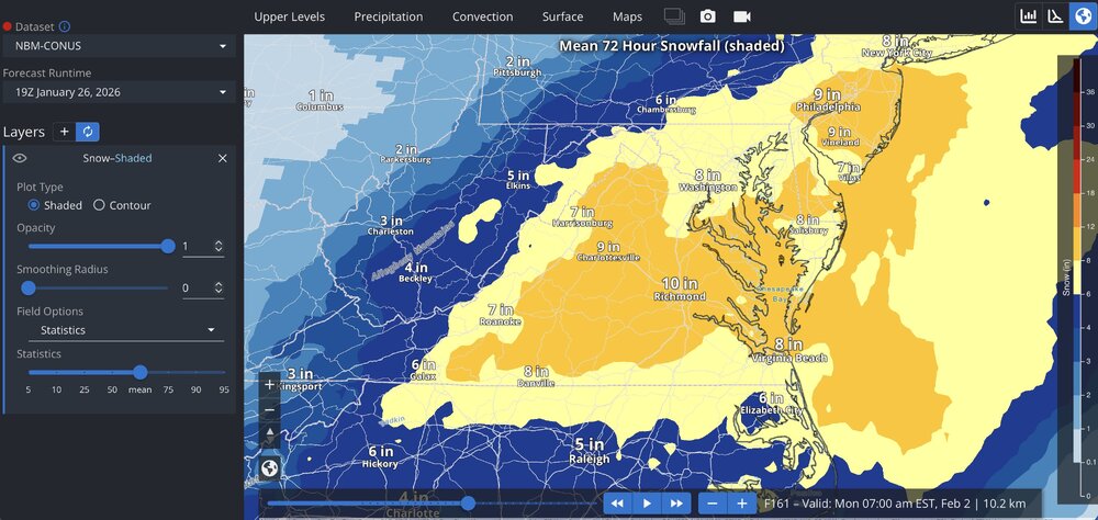
-
Richmond Metro/Hampton Roads Area Discussion
Dick_LeBoof replied to RIC Airport's topic in Mid Atlantic
The snow signature from the visible GOES band is really impressive. What a storm.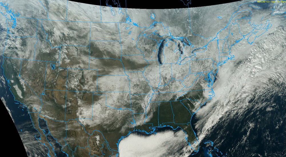
-
Richmond Metro/Hampton Roads Area Discussion
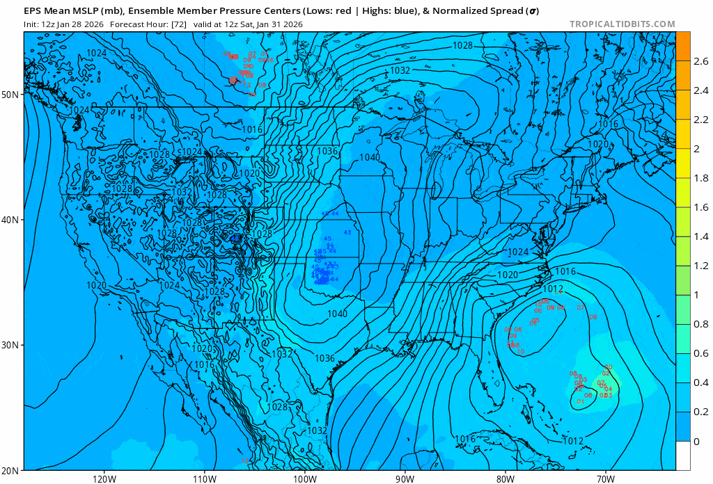
Dick_LeBoof replied to RIC Airport's topic in Mid Atlantic
Here's the EPS Ensemble pressure centers from last nights run (06Z). Will hopefully see the members tighten up around the coast in the next run.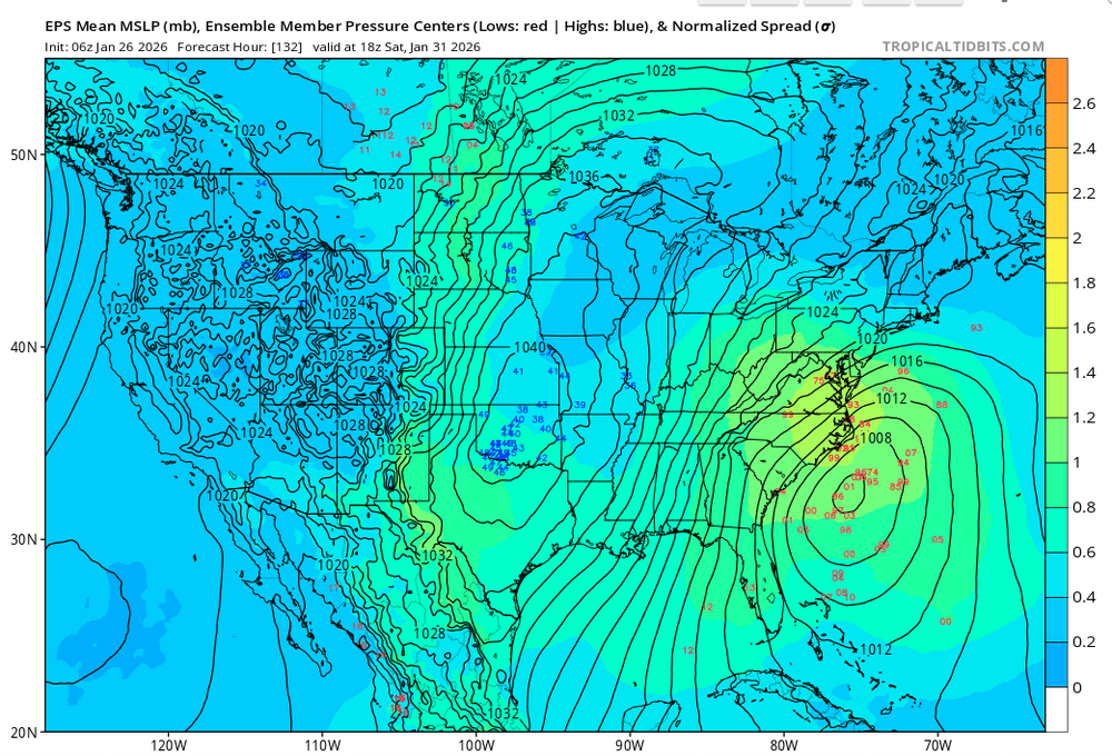
-
Richmond Metro/Hampton Roads Area Discussion
Dick_LeBoof replied to RIC Airport's topic in Mid Atlantic
How nice is this? It's the tiniest little clipper you can imagine on the radar right now haha. -
Richmond Metro/Hampton Roads Area Discussion
Dick_LeBoof replied to RIC Airport's topic in Mid Atlantic
We’ve got flakes coming down now in Church hill . -
Richmond Metro/Hampton Roads Area Discussion
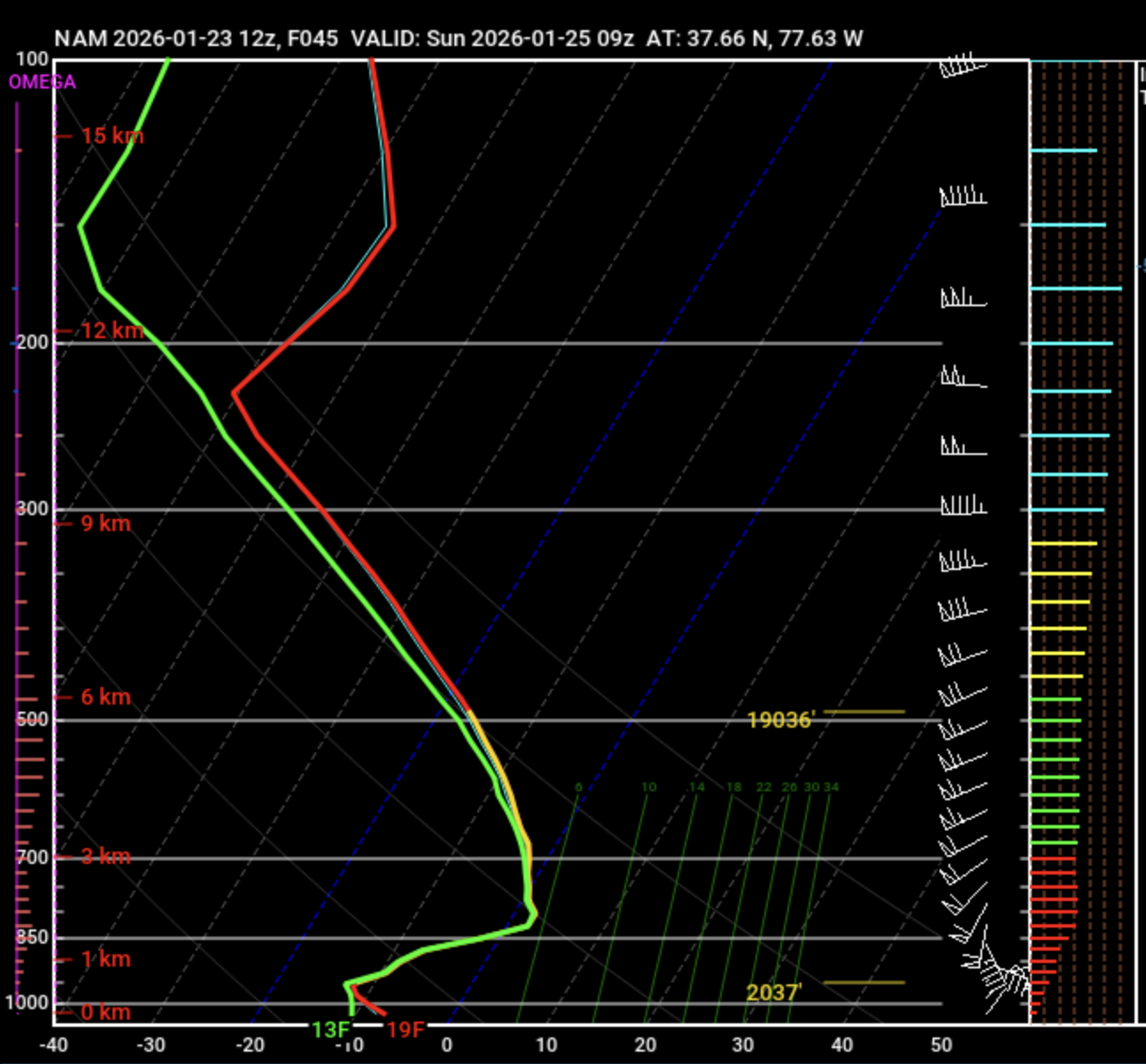
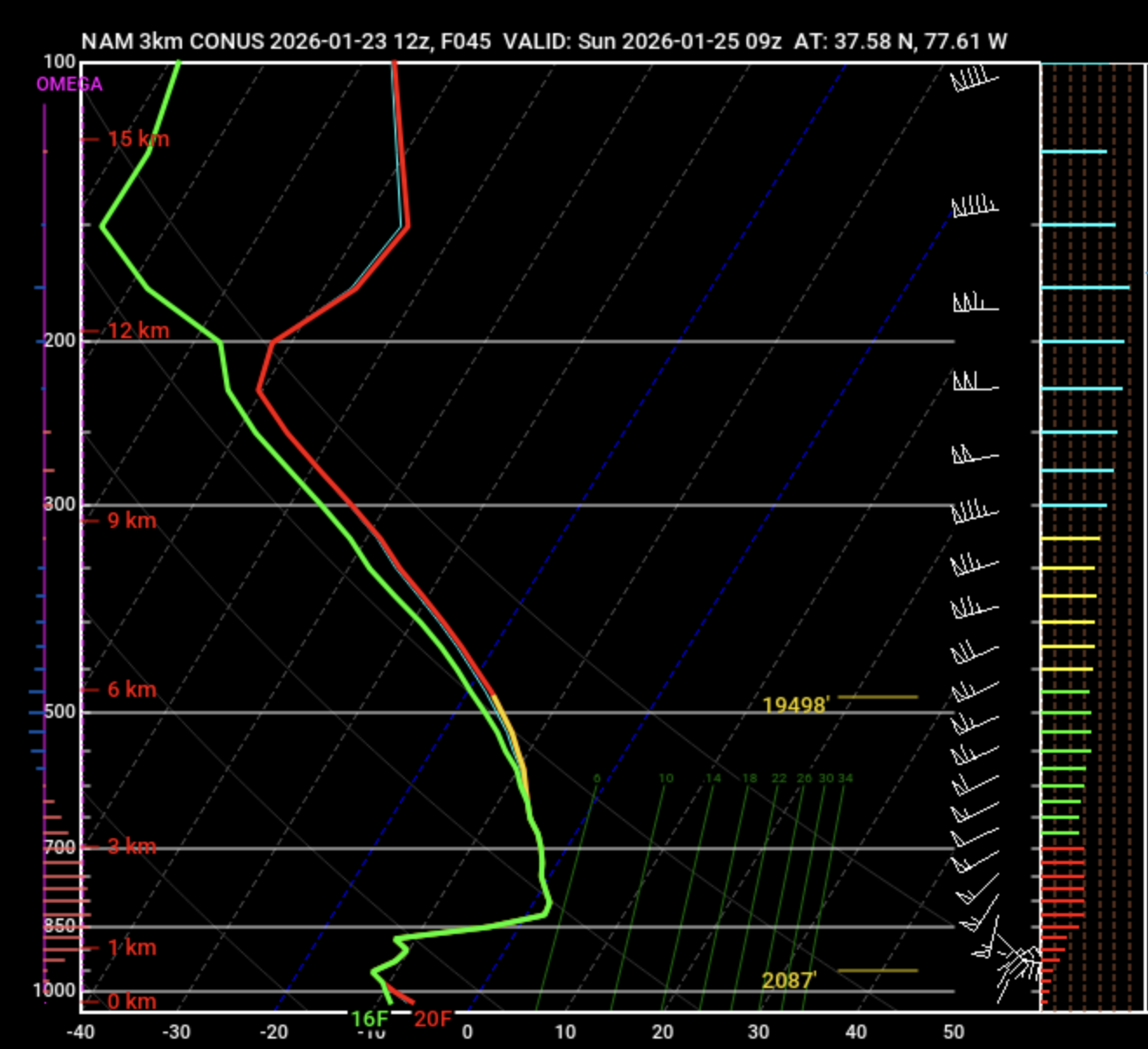
Dick_LeBoof replied to RIC Airport's topic in Mid Atlantic
So I'm taking a look at the NAM soundings for at Sunday 9z (when the sleet line crosses into our area) and based on my untrained eye, it seems REALLY close. No wonder the models are struggling with the mid-level thermals.

-
Richmond Metro/Hampton Roads Area Discussion
Dick_LeBoof replied to RIC Airport's topic in Mid Atlantic
Trends are looking much better for us in RVA. Seems like the bleeding has stopped for now. I'm excited to see how the NAM models the mid-level thermals. This seems to now be the primary focus for our totals now. -
Richmond Metro/Hampton Roads Area Discussion
Dick_LeBoof replied to RIC Airport's topic in Mid Atlantic
Anybody else thinking the models are underestimating the CAD? My thoughts are that the broader synoptic pattern is generally what we are used to seeing for snow events, but the current arctic air mass is more intense than we usually see. -
Richmond Metro/Hampton Roads Area Discussion
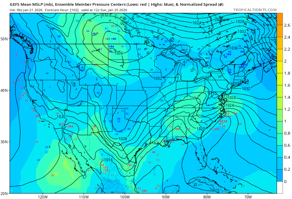
Dick_LeBoof replied to RIC Airport's topic in Mid Atlantic
06Z GEFS run. Looking like still a decent spread in possibilities of where the coastal low sets up. There's still a good amount of southern members, so I'm not panicking yet. My question is are the models underestimating the CAD that will be in-place by the time the system rolls in. The low-temp this morning in RVA was a few degrees colder than forecasted. Hoping the CAD will be deeper than the models are showing. GEFS Ensemble Pressure Centers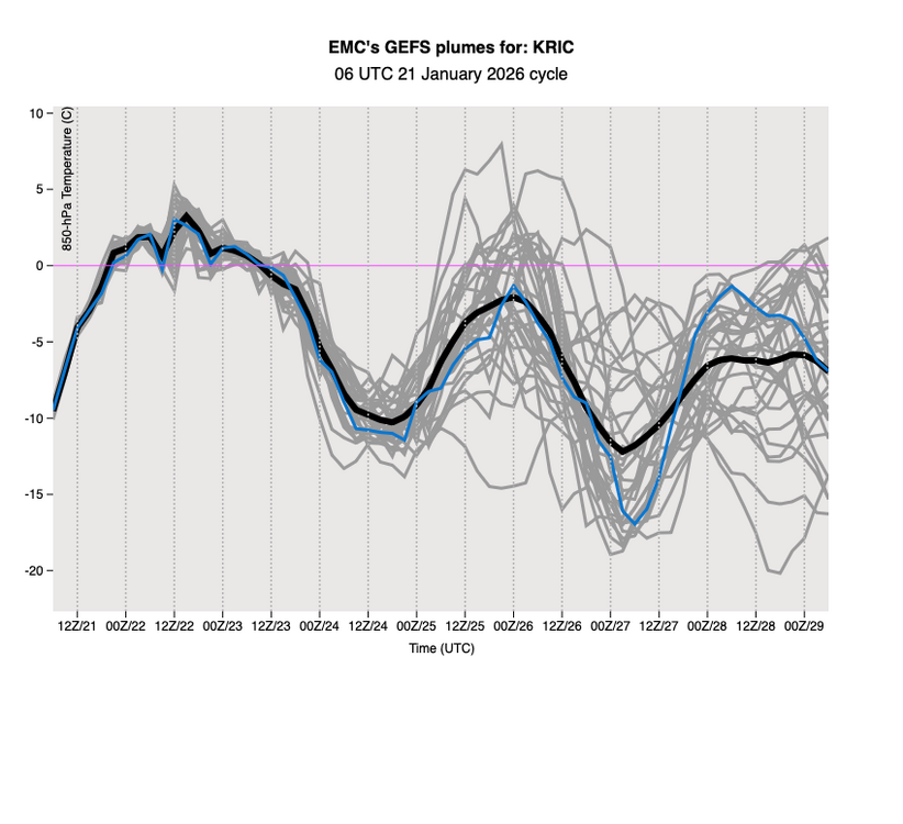

-
Richmond Metro/Hampton Roads Area Discussion
Dick_LeBoof replied to RIC Airport's topic in Mid Atlantic
Precipitation shield is really filling in nicely now from the south. Looks like the Richmond metro is about to get a heavy band. -
Richmond Metro/Hampton Roads Area Discussion
Dick_LeBoof replied to RIC Airport's topic in Mid Atlantic
Incredible trends for the Richmond Metro! Looks like the models are expecting a good initial thump via frontogenesis. -
Richmond Metro/Hampton Roads Area Discussion
Dick_LeBoof replied to RIC Airport's topic in Mid Atlantic
"WhY wOuLd ThE mOdEls Do ThIs To Me?!" -
Richmond Metro/Hampton Roads Area Discussion
Dick_LeBoof replied to RIC Airport's topic in Mid Atlantic
Radar is filling in that dry band now. I think the next 1.5 hours is our window. -
Richmond Metro/Hampton Roads Area Discussion
Dick_LeBoof replied to RIC Airport's topic in Mid Atlantic
Found a nifty visual showing the recent runs off the GFS/NAM/HRRR. 3 runs going back to the 06z.ForecastHourlyWeatherData.jpeg.thumb.png.df10b64458e5cf20420a286b7417038c.png)
-
Richmond Metro/Hampton Roads Area Discussion
Dick_LeBoof replied to RIC Airport's topic in Mid Atlantic
That's fair. The models have consolidated now, but it's within 12 hr of the first flakes falling. I guess I'm surprised with how much the globals swayed leading up.


ForecastHourlyWeatherData.jpeg.png.385d391463eab1b126a78f325f131d1b.png)