

MDRandy
-
Posts
26 -
Joined
-
Last visited
Content Type
Profiles
Blogs
Forums
American Weather
Media Demo
Store
Gallery
Posts posted by MDRandy
-
-
3 minutes ago, Interstate said:
31.3/29 light snow
Prigel?!
-
 1
1
-
-
33/31; light snow
-
1 minute ago, blueberryfaygo said:
I am just saying that the last several events have been inhibited by near freezing surface.. the COB output depicts these issues pretty well. I am sure hunt valley will be fine. I am in the City so I worry more about these things. I think that we are all going to be pleasantly surprised with this one.
I'm at 37/27 currently in the city.
-
41/25; Canton
-
39/24; already surpassed our forecast high
-
Just now, WinterWxLuvr said:
Maybe so but he will hug the hell out of the euro
Which usually works out long-range wise, not so much short-range.
-
1 minute ago, Wetbulbs88 said:
I’d be happy to lol. What’s his FB?
I appreciate his long-range forecasting, but his snow maps typically reflect his Richmond bias.
-
Is LWX going straight to advisories/warnings tomorrow?
-
I guess the Riverside neighborhood has its own microclimate

-
10 minutes ago, Baltimorewx said:
Im thinking that station is running a little high...but alrighty lol
It's down to 51 now, so I agree; seems like an unreliable station. Anywhere from 47-50 seems reasonable for downtown currently.
-
3 minutes ago, jayyy said:
That’s wild. It’s 40.5 here.
NW Baltimore is at 44; there's usually a 5-10 degree range between downtown and NW.
-
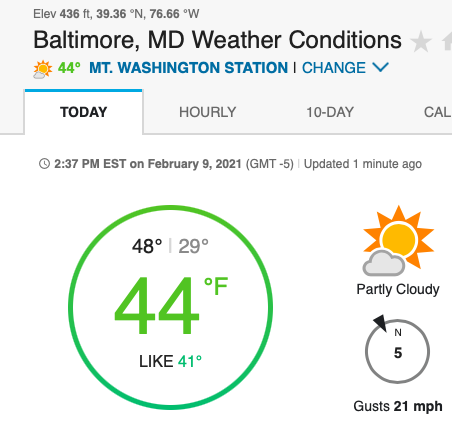
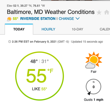
1 minute ago, Baltimorewx said:
55? Wheres your weather station, the top of the Legg Mason building ? lol
-
1 minute ago, ovechkin said:
50 already downtown. We blow by forecasted highs more than DC drivers blow stop signs.
55 and climbing in the tropics of downtown Baltimore.
-
5 minutes ago, Baltimorewx said:
It’s really pathetic. I mean even places that should be warmer in southern MD and the eastern shore are getting more snow than us
I will take responsibility for the Baltimore snow hole.
-
1
-
-
Another Sunday, another busted forecast for SE Bawlmore.
36/33 with a cold rain. Accumulated precipitation: rain puddles
Looks like ol Kooky Uncle Randy's fears about mixing along the 95 corridor were justified after all.
-
1
-
-
8 minutes ago, jayyy said:
Crazy. It’s 6 degrees colder in east HoCo (south of 70) and 8+ degrees colder up north (Carroll, north Baltimore, Frederick counties) . What a difference.
Yes sir. NW Baltimore (Mt Washington) is reporting 33; I'm SE (Canton) at 41. Downtown is 42.
-
Balmy 41/28 in Charm City
-
7 minutes ago, MD Snow said:
FWIW ICON has ticked the rain/snow line further west each of its last 4 runs. That run was mostly rain for many areas on the eastern shore. One more tick and we're talking mixing into the I95 corridor.
You're gonna have the weenie police all over you for that post.
-
10 minutes ago, nw baltimore wx said:
This is a completely different system. We don't have a low to our west driving north of our latitude with a transfer to the coast.
eta: Just saw your post, but my point, which you get, was that your not comparing apples to apples.
Do you think there will be enough blocking to prevent further NW trends? Just curious.
-
1 minute ago, MillvilleWx said:
This isn't even in the same stratosphere as the last system. Evolution and moisture transport are totally different. Upper levels are different. This will come down to rates and evap cooling of the lowest 3000' in the boundary layer. Baltimore still looks good, but areas west of I-83 need to watch for anymore NW trend.
Not saying the genesis of the storms are similar at all - just noting the similarities in trends.
-
Another win for the Euro by the way. The GFS has had as much success at long-range forecasting as the Buccaneers are going to have slowing down the Chiefs offense on Sunday.
-
1
-
-
Just now, North Balti Zen said:
The council has met. You are summarily banished from the realm.
I'm a meteorological prophet.
-
3 minutes ago, DCTeacherman said:
Of course you never can be certain and the favored climo areas usually do better, but I like where the 95 corridor sits for this one. We're about 36 hours from game time and most global models and mesos target our area or just SE with the heaviest stripe, with a little wiggle room for a late NW shift. Plus, this almost feels like a bonus event after 2 fifty degree days.
Just like last week when model consensus at this time consistently showed double digit totals up and down 95.
-
One more tick NW - probably tonight or tomorrow - and the 95 corridor is just a rain/snow mix. This looks like a 81 corridor special
-
 1
1
-
 1
1
-
 3
3
-
Feb 18/19 Disco/Obs
in Mid Atlantic
Posted
30/13 SE Charm City