

NJDevs29
-
Posts
31 -
Joined
-
Last visited
Content Type
Profiles
Blogs
Forums
American Weather
Media Demo
Store
Gallery
Posts posted by NJDevs29
-
-
4 minutes ago, Kevin Reilly said:
Looks like just along 95 north west sitting pretty good right now rain issues coast to about 35-40 miles inland for now.
That’s a little off, puking snow here just over the river from philly
-
13 minutes ago, Ralph Wiggum said:
Best banding definitely East over NJ. Congrats @The Iceman and others in Central NJ! Should easily see 5" lollis those parts.

Yeah I think closer to the coast you are the less accumulation you’ll see. I like the far left area of the circle tho lol
-
All snow here in maple shade
-
Looks like another 6-8 hours of light snow to go.. great storm
-
No bust here in maple shade! Have to be around a foot maybe more
-
2 minutes ago, Ralph Wiggum said:
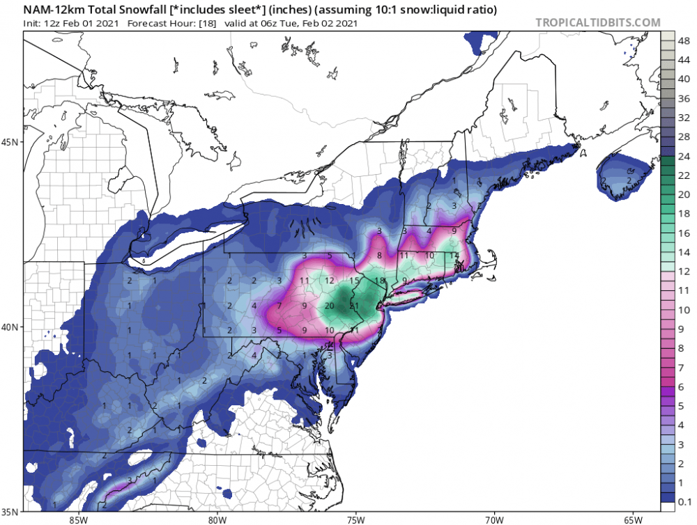
12k NAM for tonight and thru tomorrow evening. Still some light stuff over parts of Eastern PA occurring during this frame. I mean, those additional totals alone are a nice winter storm for most of us that we would be tracking for days. Most models like the additional accums. We take.

Matches hrrr well surprisingly
-
2 minutes ago, chrisl said:
I’m seeing 5-6 for the 130 corridor on the hrrr. A lot of the on air Mets seem to be just saying snow showers tomorrow but the banding on the hi res models looks very good for SNJ. Honestly think some people may be caught off guard tomorrow especially if there’s a lull early morning
Yupp, sign me up
-
 2
2
-
-
Hrrr still showing an additional 2-4” coming around the Philly metro area.. wow
-
1 minute ago, chrisl said:
Hoping we can push 12 but seems like a dry slot moving through Pemberton rn. Either way hi res models look good for banding tomorrow afternoon too
I like our Chances
-
1
-
-
Just now, chrisl said:
Yeah we've been under this nice band for a while from AC to our area. Hoping we can keep with this band for a few more hours. Had about 3.5 yesterday then the sleet but I'm not sure what we're at total now (I'd guess 8)
Yeah I measured 9 here!
-
1
-
-
Good rates in maple shade
-
Snowing here now!
-
1
-
-
Snow flakes becoming much more visible here now
-
3k nam also agrees
-
Just now, jrodd321 said:
Wow. Nam just wrecks us for the next 24 hours. Damn consistent now ever since jumping on at 00z. Buckle up guys this going to be a wild afternoon.
From Philly on north will do well
-
-
Just now, TheBigBlueBox said:
Yup. It’s just that I’m concerned we stay sleet or mix when the heaviest precipitation comes in a few hours. I know it will eventually change over but it needs to line up with the heaviest precipitation to get the big totals.
Can’t see how Philly area doesn’t pick up at least 8” or more
-
1 minute ago, TheBigBlueBox said:
No way anyone in the PHL area is getting a foot unless this sleet changes over soon. Been nothing but sleet for 12 hours here just outside of NE Philly. We might get a 6” of sleet lol.
You do know the storm doesn’t end until tomorrow, right?
-
2 minutes ago, hurricane1091 said:
I think this is panning out exactly how models dictated, namely the GFS. Mixing was always going to come right up into Philadelphia, it was so weird that many people and the local news ignored that. Anyways, maybe 3" total one mile from PHL, some sort of sleet precip falling. Some of the crazier numbers of 8-16 were never going to happen here, was kind of weird NWS would say that. Probably still a 4-8 or 5-10 situation which is still significant.
Sounds like a premature statement to me.. let it play out
-
Still a snow/sleet mix here in maple shade
-
Hearing rumors the 850mb low has setup further east than modeled
-
Just now, TheBigBlueBox said:
What is it doing now in Maple Shade?
Snow/sleet mix, winds have noticeably picked up
-
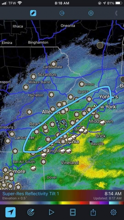
Radar is really starting to fill in now, best of luck all
-
2
-
-
9 minutes ago, kickingupastorm said:
Well this has been a major let down
This was literally forecasted to happen.. have some patience
-
 1
1
-


Feb 7th discussion/obs
in Philadelphia Region
Posted
Right along 95 might be the spot to be