

Snowmadness
-
Posts
125 -
Joined
-
Last visited
Content Type
Profiles
Blogs
Forums
American Weather
Media Demo
Store
Gallery
Posts posted by Snowmadness
-
-
I’m still learning here but seems the two pieces that have yet to line up this winter is a -NAO and +PNA at the same time. Plus the pacific jet has been relentless. Part of December, we had all indexes favorable except PNA.
-
On 1/22/2023 at 12:59 PM, CAPE said:
Ten+ days out and this is only a 6 hour panel. You get the general idea.

Will Take P-4 or P13 !! Let’s Go!! lol
-
3 minutes ago, psuhoffman said:
Euro and GGEM are keying on a different SW than the "threat" the other day. I didn't like the angle of the other threat, amplifying too far east, I've seen how that ends multiple times the last few years. This one has more space to work with and is amplifying far enough west for me to think it has a shot. In the end temps are more likely to be the problem here not track.
Hopefully the MJO index will help with cold if forecast verifies w/ a move into 8/1
-
 1
1
-
-
41 minutes ago, Sandstorm94 said:
0z so far:
GFS: improved
ICON: improved
CMC: improved
Sent from my SM-S102DL using Tapatalk
Still learning here and not experienced like many but over the past three GFS runs the trough has been shifting eastward
-
6 minutes ago, TSSN+ said:
Slight push east on gfs. Also secondary pops. Backside snows.
Yeah I saw that. Maybe it’s a new east trend…
-
I know we want the snowiest output but which model handles the upper levels better. GFS or euro?
-
Digging further west this run
-
1
-
-
29 minutes ago, WinterWxLuvr said:
Short Pump?
I live in Short Pump….lol. Western Henrico. (Basically suburb of Richmond) Nice area, lots of commercial development. Housing costs a little pricey.
-
 1
1
-
-
Santa, All I want for Xmas is the 12z to verify!!!
-
10 minutes ago, Weather Will said:
I don’t understand why we can’t have it snow on the 23rd as well as the 26th… big hits on the individual WB 12Z members.


Will take E 47!
-
1
-
-
Don’t post much but check out WX South post on FB. Seems pretty excited about the upcoming pattern. I can’t post it here, file too large.
-
12z NAM north this run, takes IAN into Myrtle Beach
-
6z RGEM looks good for rain totals here
-
Seems on Satellite passes, Ian is heading NE (Not NNE) and Should exit off Florida at a lower latitude then what models are forecasting. If so, that could have implications in our area possibly taking storm further out in Atlantic before the “left bend” takes place.
-
1
-
 1
1
-
-
Heard 18z EURO was north of other guidance. Anyone have a link to view?
-
That’s the 2nd NAM run to show this. The other hurricane models at 18z are also shifting tracks more east into central/southern SC. Could be a trend….
-
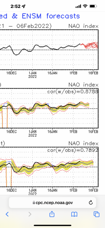
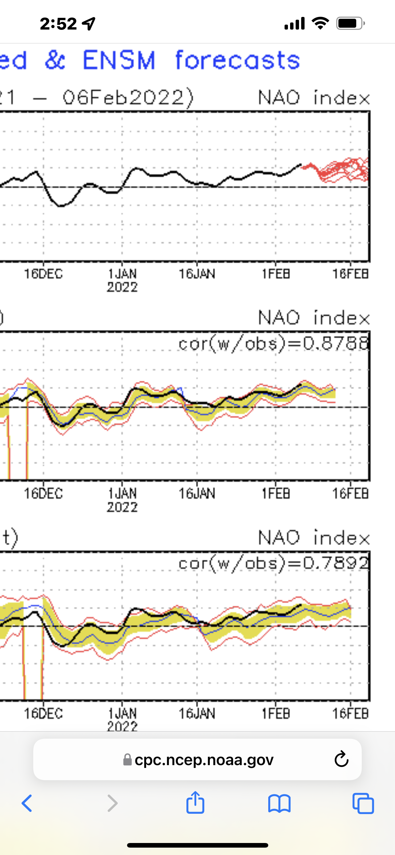
NAO is relentlessly positive
-
1
-
-
52 minutes ago, cbmclean said:
You are not mistaken. We also had -NAO for a good part of this past December. Unfortunately in both cases it was largely rendered moot by Pac Puke.
I agree with the PAC puke but we had a marginal negative NAO for maybe 3 decent days this December then for a day or so later in December. was not prolonged or sustained to help us much.
-
(Speaking from Richmond) For last two winters, the NAO has never gone negative for more then a day or two the entire winter. It is frequently negative rest of the months but for some reason, from early December to Mid March it is always strongly positive for slightly above neutral. Zero Blocking. This winter is especially bad. Guessing La Nina has a lot to do with it. I really don’t understand the science behind what drives the patterns other then how the indexes show favorable or unfavorable patterns. Now, the only favorable index this winter, the PNA is forecasted to go negative and MJO entering warmer phases. Maybe we may get lucky mid March if pattern can flip back, -NAO blocking and MJO can cycle back around to 8-1. Until then, it seems we need absolute perfection and timing of cold fronts and low positions to give us a good winter storm. Super low odds with all the vortexes flying around. I think we have had like 6 inches (RVA) total between all the storms. North, South, East and West of us have a foot plus. Sorry to rant. Just a frustrating winter for us. If this happens again next winter, I will seriously storm chase the next big snow even if I have to fly to Maine or Canada….lol …Sorry to rant.
-
2
-
For last two winters, the NAO has never gone negative for more then a day or two the entire winter. It is frequently negative rest of the months but for some darn reason from early December to Mid March is always strongly positive for slightly above neutral. Zero Blocking. This winter is especially bad. Guessing La Nina has a lot to do with it. I really don’t understand the science behind it. Now, the only favorable index this winter, the PNA is forecasted to go negative and MJO entering warmer phases. Maybe we may get lucky in mid March if pattern can flip back, -NAO blocking and MJO can cycle back around to 8-1. Until then, it will take absolute perfection and timing of cold fronts and coastal low positions to give us a good snow here in RVA. Super low odds with all the vortexes flying around. I think we have had like 6 inches total between all the storms. North, South, East and West of us have a foot plus. Sorry to rant. Just a frustrating winter for us. If this happens next winter, I will storm chase the next big snow even if I have to fly to Maine or Canada….lol
-
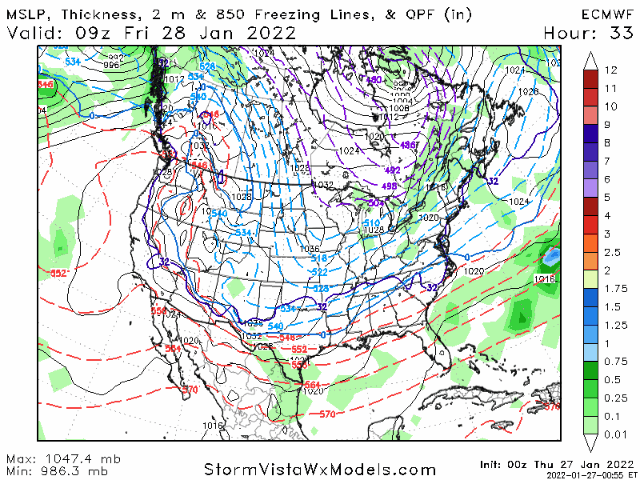
12z Euro has the storm as well
-
2/6 Storm
-
1
-
-
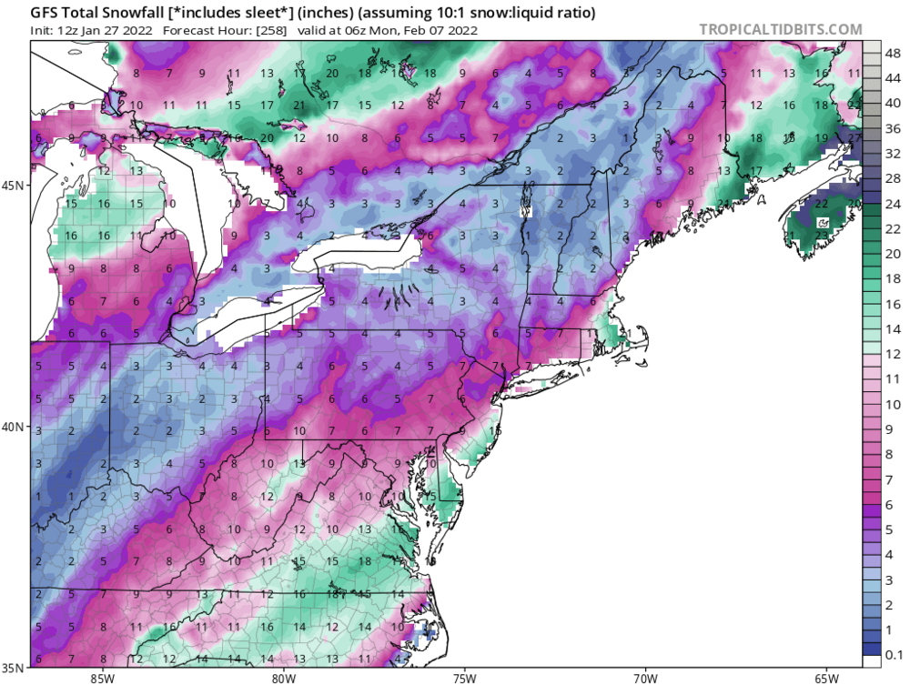
Yeah 1-3. maybe 4 inches. There is a much bigger storm showing up again on GFS for 2/6.
-
Euro def still in the west camp. Wasn’t as great as short range models but not like the GFS.
-
1
-


January/February Mid/Long Range Disco IV: A New Hope
in Mid Atlantic
Posted
P16 will keep everyone happy..lol…seems like we really need a -NAO and +PNA to occur at the same time.