

coastal front
-
Posts
29 -
Joined
-
Last visited
Content Type
Profiles
Blogs
Forums
American Weather
Media Demo
Store
Gallery
Posts posted by coastal front
-
-
22 minutes ago, CAPE said:
Not gonna lie, I really want the 5-6th window to work out. Been tracking it for ages it seems, and it is still almost 10 days away lol. How great would it be to get a moderate event leading into what looks like the period with the most upside this winter.
Can we get another cape storm??
-
 1
1
-
-
Euro with a day 9 BOMB
-
2
-
-
1 minute ago, Heisy said:
One of wildest H5 runs I’ve seen in a while


.I’m assuming the euro kicks out that diving clipper a bit quicker than the gfs to allow for some amplification?
-
Upgraded to a warning overnight just inland from Atlantic City. Already with an inch and we should rock later on. Now let’s watch that radar fill in nicely.
-
3
-
-
Just now, stormtracker said:
Fucking South/Central Jersey. Fuck those guys.
woahh as a south jersey resident I usually look at you guys as my home thread because for the most part my climo is more similar to dc rather then NYC and that Philly thread is dead. Good pbp!

-
1
-
-
About to enter a thicker rope here just outside of Atlantic City. Winds have been roaring for the last couple hours
-
3
-
-
Man Franklin has had some of the most intense convective bursts I’ve ever seen.
-
1
-
-
20 minutes ago, Weather Will said:
Suppressed track continues on 6Z GFS.
That’s exactly where we want it. I think this suppression fear is way over blown considering not 1 storm this year hit south of us.
-
1
-
 1
1
-
-
1 minute ago, jayyy said:
It’s snowed in late march before. Over a foot in DC actually. And my area can certainly get crushed in late march. Not everyone lives where you live bud.I second this. Around 6 years ago in south jersey we got around 5-6 inches in early April
-
2
-
-
I’m Honestly surprised how quick this ewrc has been progressing.
-
1
-
-

18z eps-
2
-
-
Over analyzing IR is not going to give you all the answers. Intensification is not linear She’s already spitting out hot towers getting ready to rotate on the north side. Everything seems on schedule unfortunately.
-
6
-
-
Ian is starting to tighten up and with d max should see some explosive rotating hot towers overnight to really set the stage for RI.
-
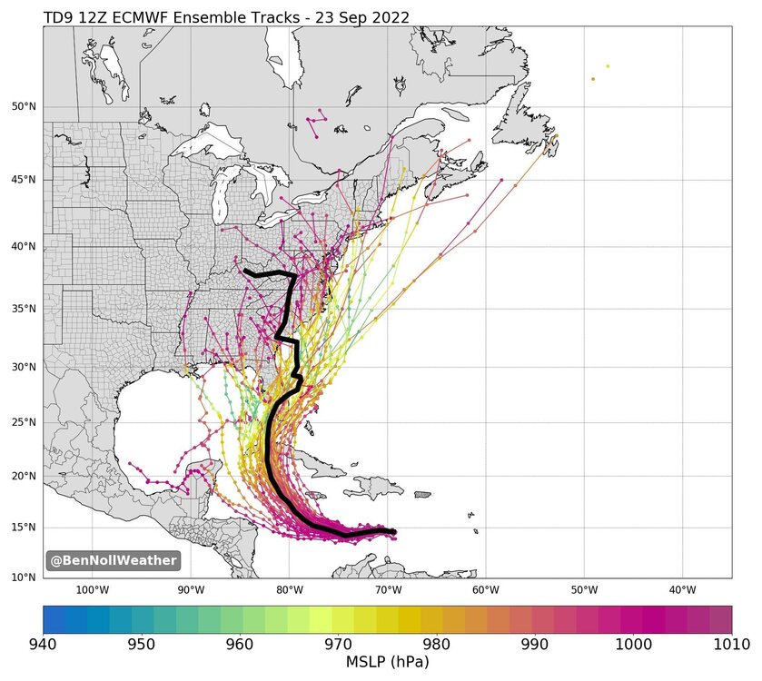 12z eps has even more members flirting with the east coast.
-
4
-
2
-
-
Euro still has a signal and that’s all we could ask for at this point.

-
18 minutes ago, dseagull said:
One of my favorite storms on barnegat bay. Had 3" an hour on the bay for 2 hours under deform band... 18.9 inches storm total. 8.5 miles inland at my deer stand had 8.1 inches. We had verified gusts to 71mph at several nearby stations. I lost mine to my patio furniture.
Lived out in ocean City New Jersey for that storm. Incredible getting 16 inches of cold powder considering how quick of a mover it was. Still to this day it had the strongest winds I’ve ever experienced in a snowstorm.
-
3
-
-
29 minutes ago, SnowDeac said:
Trending towards almost all ZR. I'm guessing about a half inch, which will be pretty devastating. Though, honestly, I also won't be surprised to turn over to plain rain eventually which will limit our issues big time. Might get a quick inch or two of snow/sleet before the changeover. Going to be depressing as always watching the correlation coefficient radar FLY up from SC through NC.
Thanks man I appreciate it. Stay safe down there and we all will get our snowstorm next weekend!
-
23 minutes ago, SnowDeac said:
Yep, I was in the same boat. GSP had Charlotte proper getting 9-11 inches. We got like 2.1 inches of pure slop. There was a similar mid-December bust with almost the exact same setup/output around that time as well.
How’s Charlotte looking for this storm? I live up in south Jersey and even we are getting all rain up here but my brother lives in Charlotte and has been asking me about it but I’m just super unfamiliar with how storms play out down there.
-
The tornado outbreak in east pa/ central Jersey with that massive EF3 a couple weeks back had very little if any sun to destabilize.
-
2
-
-
Yeah I think we literally just kicked off an explosive episode of deepening. Hopefully recon will hang out there for a bit during this process.
-
5 minutes ago, FLweather said:
But probable
Just like everyone saying it's heading to New Orleans.
Models can only do so much. Especially during the fact that you have a TC strengthening.
I can tell you that the current center fix with a strengthening center is already too far east and curving to make landfall in New Orleans.
It's going to be east.
Is this turtle’s burner account?
-
 13
13
-
-
She will close that eye wall off relatively soon and it’s all systems go after that.
-
18 minutes ago, dizzy9479 said:
Admittedly a bit jealous. Being from southern New Jersey, we don't get this kind of weather often. I'll be in Gulfport for work next week at this time - a week too late, haha. Hoping you all experience minimal disruption and damage but get to see some nice gusts!
South Jersey represent! I’m out in Atlantic county man and I feel the same way you do. Would love to truly witness a hurricane at one point and not an extra tropical Hybrid decaying mess. Don’t get me wrong I do understand the impact storms like this can have on lives and wish everyone the best but as a weather nut you can’t help but want in on the action
-
2
-
-
2 minutes ago, RedSky said:
They got the beach! The beach is where snow turns to rain, thunderstorms go to die and warm spring days turn to mist and fog. Don’t get me wrong the beach is great but super disappointing from a weather perspective


The Weekend Rule? Saturday 2/17 - The Icon Storm
in Mid Atlantic
Posted
Not tonight chuck