

howrdcounty snow
-
Posts
49 -
Joined
-
Last visited
Content Type
Profiles
Blogs
Forums
American Weather
Media Demo
Store
Gallery
Posts posted by howrdcounty snow
-
-
Oh, and as long as the streams stay somewhat split with cyclones breaking near north america, it can redevelop more nao blips. Since this is a function of cyclone development, models can easily lose signal in extended range. Something to keep an eye on. AAM /Pacific is hostile.
-
very good read
Friday Funny: nature makes a mockery of month-ahead model forecasts.
-
 1
1
-
-
MJO phase diagram
Current Phase:Archive:
-
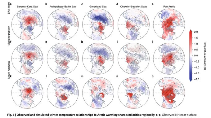
Arctic heating near the Barents-Kara Seas is related to a cold Asia, heating in the Chukchi Sea is related to cold North America but heating near Greenland brings equal opportunity cold to Asia, Europe & North America, consistent with latest GFS forecast: https://rdcu.be/bZAqO
-
1
-
-
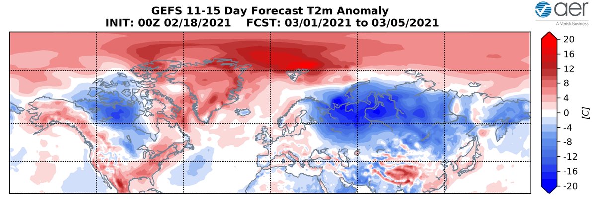
"March, in like a lion out like a lamb." GFS predicting the first part should be correct as blocking shifts from Europe closer to Greenland allowing relatively colder temperatures to return to both Europe & the Eastern US. Still just a forecast but impressive expanse of cold air!
-
2
-
-
FROM LARRY COSGROVE
This is a formula for entrenched, low-latitude cold and cases of heavy snow and ice. But given that the first piece of energy in the series will be further north, the scenario I have constructed is for a Colorado cyclone to progress eastward into Virginia, then curl up along the coastline of the Mid-Atlantic, New England and Maritime Province. Timing is uncertain, but using the ECMWF ensemble package, between February 25-28 should fit.I do not think we get out of the rest of calendar winter without yet another major weather event. If the next two in the series, acting with a motherlode in the Great Lakes region like we have currently, an area from the Great Plains to the Eastern Seaboard (probably minus the Deep South, but you never know....) could be hit with major snow and mixed precipitation potential. Given that the 10MB circumpolar vortex is again unified and deepening, I think that we start to see meaningful warm-ups below 40 N Latitude in the last week of March. With thunderstorm threats.
But it's going to take some time, this time! -
1 -4 in snowstorm then 3 ice storms, great md weather, with blocking, reminds me of the winter of 94, Siberian express and nothing but freezing rain for the whole winter, closed down the pentagon for a week it was so cold. Now who knows what's next!!!
-
FROM LARRY COSGROVE a long winter still ahead FWIW
Even though there are model forecasts that suggest the stratospheric warming event will collapse in the first week of March, lower layer translation of the 10MB features is usually not seen until perhaps three weeks later. Personally, I believe the analog forecast thats says we will have to wait until the first week of April before our current colder pattern breaks down. The analog system scored very well in December and January, and pointed out the recent tendency for pronounced -NAO ridging and European cold. And also showed the split storm track pattern, though not as strong as what actually transpired through the southern and eastern U.S. last month.
-
1
-
-
7 minutes ago, IronTy said:
I'm getting a bad feeling about this.
gfs-euro 5 days out fantasy
gfs -euro 48 hrs out reality
basis 62 years of following the weather
-
1
-
-
what woman did her dr thesis on the NAO and east coast storms
-
10 minutes ago, Hurricanegiants said:
It’s funny. Back on January 24, 2000 we had the surprise snowstorm—- it was supposed to be south—a fish storm. And it wasn’t until after 9:00 pm—-hours before the onslaught that the NWS issued the last minute warnings. This storm has neither the L or the coastal power, however, the waffling that it’s creating is reminiscent of that storm. There just seems to be similar intangibles (VA Beach, suppression, maybe 1-2–probably rain/freezing etc...). Shall be interesting.
blizzard of 66 was the very same way
-
I remember the last great over running event , my mother died the next morning, got almost 2 ft
-
 3
3
-
-
1 minute ago, BristowWx said:
South East Ridge. Our arch nemesis....sometimes
2 minutes ago, BristowWx said:South East Ridge. Our arch nemesis....sometimes
thanks, I don't post very much so I appreciate your comments
-
3 minutes ago, BristowWx said:
Pretty sure the PAC will make sure we cross that worry off our list. We’ll be tracking the western trough and SER. Let’s see what 6z GFS shits out.
aw I don't consider it a worry, more like a joyous event considering how much snow we have had so far, I don't know what a SER is, there is always something wrong to us getting snow, but WTH
-
well son of a gun, now we have a ku to possibly track
-
17 minutes ago, Ralph Wiggum said:
Nevermind, spoke too soon

thanks saved me from looking
-
22 minutes ago, Ralph Wiggum said:
Just waking up here. Are we still on track for epicness beginning the 15th then epicness with epic cold starting the 20th? Trying to plan ahead. Thanks.
are you talking about epic cold like 77,, or 93 I believe?? the bay froze in 77 and 93 also
-
46 minutes ago, psuhoffman said:
It was a little odd how it didn’t phase the initial wave and instead had it wash out in favor of the wave behind. But the h5 evolution of that second wave was just classic. It was a nice ending to a very good night. Cheers.
what is the precipice type for the 2nd storm??
-
after all the posts of 500 mb driving factors lining up to give us a chance of snow, there is mostly 1 or 2 factors that don't and we end up with little or nothing. That is the story of winter in the MA. And that doesn't count the storms we get that aren't forecast correctly, like the blizzard of 66 the for 5 days, wasn't going to affect us
-
1 minute ago, WhiteoutMD said:
Not showing at the surface but with that pass the precip would be more north and west I would imagine I like it at this point
that is an understatement!!!
-
1
-
-
2 minutes ago, mdhokie said:
yea but then you are stuck in harrisburg the other 350 days it doesnt snow.
he has lived there for 50 years and he has no complaints
-
15 minutes ago, JakkelWx said:
rainstorm after rainstorm. when will this shit end?
my friend , who loves snow, moved to Harrisburg and is quite content.
-
19 minutes ago, Wentzadelphia said:
EPS looks fine to me. There could be a relaxation, but pac improves. Rememver our pattern change wasn’t until after this potential event. This would just be icing on the cake. Still forever to go. I’d favor maybe the southeast and mid Atlantic right now. Think euro OP didn’t have a ton of support who knows

and the rest of the GFS run is rain-an inland runner and a cold front.- and that takes us to the 18th. I'm realistic about our snow chances regardless.
-
1
-
-
curious
Replying toThe SSW is far-reaching and affects every other thing you hear about in medium range forecasting. It's, again, like the ENSO of subseasonal forecasting. It reshapes the playing field in which the synoptic scale features evolve within.were all hoping that, as a result of SSW, cold and snow will be the end result of this paradigm going on in our atmosphere, except.....dec30 2020


March Long Range Discussion
in Mid Atlantic
Posted