

Oliviajames
-
Posts
35 -
Joined
-
Last visited
Content Type
Profiles
Blogs
Forums
American Weather
Media Demo
Store
Gallery
Posts posted by Oliviajames
-
-
Has anyone heard from Isotherm? Not trying to ruffle any features just curious if anyone heard from him. I loved his calls
-
 1
1
-
-
28 minutes ago, WestBabylonWeather said:
I’m not familiar with the MJO.
I decided to read up on it a bit
seems record snows and higher chances of snow occurs during phases 7 and 8 here in the northeast. Why is that?
Also to add the convection (thunderstorms) cause ridging in certain areas and then troughs in certain areas.
-
 1
1
-
-
1 hour ago, forkyfork said:
the 90s outside of two great years were garbage
Memories of those years cloud the bad years for many. We have been spoiled the past twenty years.
-
1
-
-
5 minutes ago, LibertyBell said:
there were way less snowstorms back then....think about how few double digit snowstorms we had.....two in 1978 and that was it for the 70s and two in the 80s and that was it for that decade.
We went a decade without a really big storm 83-93
-
2
-
-
It looks like rates could approach .5 - .75 an hour for a few hours. If models don’t back down on the intensity I think NW of Philly could be 2-4
-
2
-
-
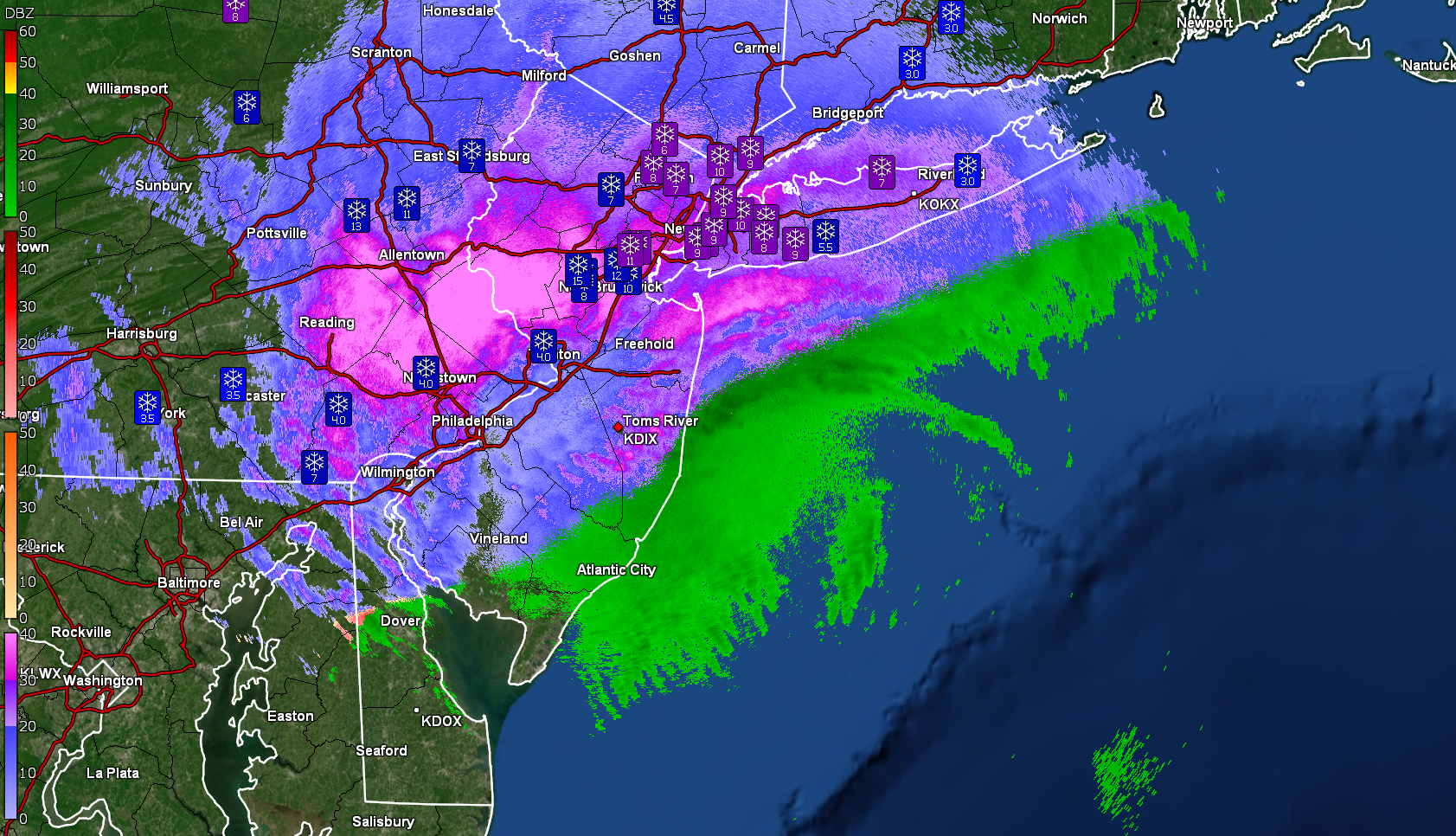
23 minutes ago, Moderately Unstable said:
My current call for the city is 4-7", including a fair amount of sleet, and .1-.2" of ice. This is based on a blend of the RPM and other model guidance (and history of model performance this season wrt mid level warmth). I don't buy all snow. RPM does show a consistent change to sleet and then FZRA on every run. How much the snow total ends up being hinges on how fast mid level warm air comes in...but we will enjoy at least a couple hours of good rates. And I will abs take that.
What are you thoughts for Berks?
-
 1
1
-
-
1 minute ago, Newman said:
Most of the individual HREF short range models paint at least 0.5" of ice across Berks and the Lehigh Valley. Remember, the freezing rain accretion maps are almost always overdone. But 0.25-0.5" of ice seems likely IMO
Berks only need .25 for a Ice Storm Warning while Lehigh need .50. I still think if anything NWS will go with Winter Storm Watch/Warning if warranted. Or if they think less likely Advisories
-
I think there is only three weeks in winter where people don’t bring up the sun angle . It is mid February people. Sun angle is limited
-
Anyone know a good storm total map for epa. Berks county mostly? I would guess I am over a foot son singing spring but could be more?
-
1 hour ago, Hurricane Agnes said:
Still have a snow/sleet/FZRA mix with temp hanging at 29. Some places are getting walloped though!

The King at 12z drops 14 on Berks County
-
1
-
-
2 minutes ago, Newman said:
HRRR is pretty dang impressive too

Berks might have a chance bud. Let’s do it
-
1
-
-
41 minutes ago, Newman said:
6" storm total thus far, sleeting as of now. My concerns are 1.) Does the CCB get out this far west? 2.) How quickly can we crash the warm layer currently in place? Regardless, it's gonna be interesting here in a bit...
You in Berks or Lancaster?
-
1 hour ago, penndotguy said:
By the Elementary school
I live in Green Valley
-
3 hours ago, penndotguy said:
Balmy 75F in Western Berks
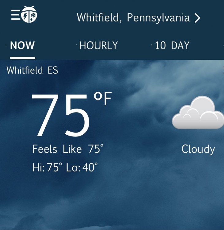
Where do you live in Whitfield?
-
12 hours ago, Ralph Wiggum said:
I'm slightly above avg snowfall to date here. Sure, we have been lacking the big monster coastal storms the past 4 years, but this feels like it will be an avg winter at the very least for us here. I will take that in a Niña for sure.
Was thinking that today on my way home from work. I got a 10 inch snow/sleet storm in December. Temperatures have been mostly in the 35-45 degree range up until this point. If we get a storm or two during our favorable period in January and possibly a quick hit of arctic air we will be about average. Maybe we can time another event in February or March to keep us happy. It would be as close to normal a winter that I can think of. This wasn’t going to be a snowy winter. I think just average/normal is a win. Let’s get it
-
2
-
-
6 minutes ago, NEG NAO said:
dry or stormy cold ?
Give me cold any day and I will take my chances with snow. Never afraid of dry and cold.
-
 1
1
-
-
12 minutes ago, wdrag said:
Hi... I see some posts on the 12z EPS.All these op model members are part of the entire group. I want to think that the 12z EC op for the northeast is a lower end member.
Checking the 12z/12 EPS ens... the qpf is just about as robust as the GEFS and basically close to the WPC 1750z solution. Snow maps (10 to 1 ratios), about the same or an inch higher than the 00z/12 cycle and both cycles are higher than yesterdays 12z. Very steady.
So, banding, IF a 700MB closed low is across LI or passing by 44025 will make up for lower qpf I84 region.
In essence, I want to see the following cycles not decrease too much.
The 850 low on the EPS is quite quite nice (see the 06z and 12z projections with excellent near 50 knot ensemble inflow). Because of 40s sst, have to think sleet rain mixed at times LI/I80 or I78 southward, (during lower precip rates) after the probable initial burst (1/2S) of snow Wed afternoon I95 corridor. Also, if it does go over... that spells trouble on further snow accumulations rates til the column cools significantly.
Attached successive cycles of the EPS storm snow, plus the 850 MB wind 06z and 12z/17, plus the 850 anomaly gradient near LI and finally the NORMAL 850 temps for OKX. To me the suggestion is 850 zero is very close to the south shore of LI.
None of this is gospel...just brings up things I try to remember to consider. I don't haven an answer but do have cautions I80 south but rossi could be right.


Thanks Walt. I am a PA northwest of Philly guy but always come to NY forum to hear your thoughts. Hoping for a blizzard.
-
1
-
1
-
-
It is not easy to get snow in the coastal mid Atlantic. There is a reason why we don’t have a lot of big snows in early December. It is just too early most times. January we will get a taste of the white stuff
-
Just now, Allsnow said:
Happy hour euro trying to make wave two a thing

This is our best chance
-
2
-
-
2 minutes ago, Allsnow said:
Important tweet for the second half of December. The mjo wave in the Niña phases can’t gain strength because of the standing wave in IO
Isn't that what happened last year when MJO looked to go into the colder octants?
-
Could not judge wind gusts but they were impressive. I would say 50mph. Lightning and thunder also.
-
1
-
-
Walt Reading is at 65 degrees. Much higher than the 59 you wanted yesterday. Squall line approaching and should be here in the next 30 minutes.
-
2
-
-
19 minutes ago, wdrag said:
NOT the entire area: This downward transfer of momentum will most easily occur where the temperature reaches near 59F which I think will be the NJ coast, across LI/CT. It's also where modeling has constantly cyclically emphasized strongest wind. I may be ~1 hour too fast on on the event but want to recheck tomorrow. I am pretty sure the squall line will be moving east at about 60-70MPH so the strongest gusts should be for a ~30 minute period (at most?) followed by a 1 hour lull then an opportunity for a westerly wind gust 40-50 MPH for an hour two, and then 3 hours after cap, winds should settle a bit, but still fairly windy Monday.
No guarantees on 60 MPH but I think with some trees (oaks etc) still leaved (extra capturing sail), somewhat softer ground due to recent rains, I think there is a pretty good chance of pockets of tree uproots/limbs down, power outages. Modeling so far is not tamping down the risk. Maybe tomorrow morning we'll lose 5 knots on the gusts?
Even so, I think it's wise to prepare for a few minutes of chaotic winds, rainfall "rates" of 1.5"/hr and possible interruptions of electric - internet service in CT/LI and I'm thinking now back to the nearest 5 miles of the NJ coast as well. Additionally ridge tops in nw NJ/se NYS/ne PA may also experience this, but am a little less convinced there.
Let's check again tomorrow and see if the forecast needs downward adjusting.
I am pretty sure a few of us will be reporting some damage-power outages Sunday evening, mainly between 6P-10P. Not...last Augusts Isais massive outages but for some, there should be interruptions.
Walt why is 59 degrees the magic number. I know in the summer convective temp that you reach for storms to initiate but not for winds in the fall with a squall line?
-
3 hours ago, wdrag said:
Good morning,
Memory jogger April 5-7 1982... ??? That was a big one from WI to NYC north... 10"NYC Northeast Snowstorms Vol II (kodis-Uccellini)
Walt I am from Reading PA and we missed out mostly on the April 82 storm. Some areas did fine with it but I don't remember that one too much. I remember a 10 inch storm probably around 87-89. I was playing outside in the snow and the only time of my life I witnessed thundersnow. I remember the flash of lightning and then the loud clap of thunder. I often try and remember what year that storm was so I can look it up. My best guess is I was in 3rd grade which would have been about 87.
-
2
-
1
-


December 2021
in New York City Metro
Posted
I remember those southern sliders in mid/late March and we had a high of 19 degrees in Reading PA. Frigid! One of my favorite things about weather is when you don’t think it is possible and it happens to show it was possible. The blizzard of 82 (April) is one that tops my list. Next day highs in the mid 20’s. I was four so I don’t remember that well but it was talked about as I grew up