

phil882
-
Posts
4,676 -
Joined
-
Last visited
Content Type
Profiles
Blogs
Forums
American Weather
Media Demo
Store
Gallery
Posts posted by phil882
-
-
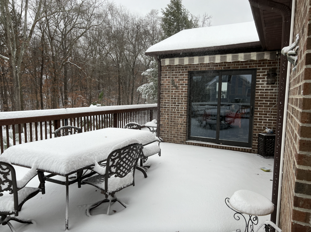
Wow I can say the back end is overpreforming by a significant margin here in Greenville. Under a very impressive band with 35-40 DBz and I can confirm we are back to moderate snow here. Waiting for this band to move out to measure again, but I suspect I've picked up another 1.5" or so from when I last measured this morning.
Temp: 28.0 F (for the event low was 24.4 F at around 930am and high was 29.5 F at around 330pm).
Dewpoint: 27.5 F
-
 4
4
-
-
Picked up around 4.5" here of snow/sleet. Changeover happened right around 7am and we have been mostly sleet with blowing snow as winds have continued to increase.
Big story is also the temp which continues to fall. Not sure how low we will bottom out before the wedge begins to be scoured out as the sfc low pivots through. Needless to say road conditions aren't likely to improve much today as we remain well below freezing.
Temp: 24.4 F Dewpoint: 23.7 F
-
5
-
-
Moderate to Heavy Snow here now... this band is quite impressive with large dendritic aggregates galore. Accumulation wise we are at nearly an inch and counting... its starting to pile up fast!
Temp: 30.9 F
Dewpoint: 30.6 F
-
3
-
-
7 minutes ago, strongwxnc said:
yeah. Bouncing but looks like around 10 -20 miles S of I-85
I'd be a happy guy if we can keep the mixing line there there until daybreak. The earlier mixing issues made me a bit worried we were going to flip over sooner than expected but now that the line seems to have settled south of I-85 we are looking pretty good for a few inches of snow over the next several hours.
-
8 minutes ago, phil882 said:
Looks like we have gone back to mostly snow, but you can tell the flakes are still partially melted and are very crusty without very well defined dendrites. I suppose beggars can't be choosers though.

Of course right after I say that we flipped back to much better quality flakes in this nice band. Snowing probably the hardest it has so far for this event.
Just slipped below freezing too. Temp 31.8 F Dewpoint 31.3 F
-
Looks like we have gone back to mostly snow, but you can tell the flakes are still partially melted and are very crusty without very well defined dendrites. I suppose beggars can't be choosers though.
-
2
-
 2
2
-
-
6 minutes ago, SharonA said:
Hey @phil882Where is "here"? Not Doral, Florida if you're getting snow
") You'd mentioned Five Forks near 85, is that Five Forks in Lilburn Georgia or one of the other Five Forks that comes up on a websearch?
You'd mentioned Five Forks near 85, is that Five Forks in Lilburn Georgia or one of the other Five Forks that comes up on a websearch?
I updated my location haha... right now I'm in Greenville, SC near the interaction of Hwy 14 & Woodruff road. Sorry I wasn't more specific earlier.
-
2
-
 1
1
-
-
2 minutes ago, burrel2 said:
a little sleet mixing here and it's evident on CC radar. Ugh... looks like the line is crashing back south though. Models show this line pushing back south of 85 and hanging out there for 2-3 hours before moving north again. Fingers crossed!
Yeah looks like we may be battling the sleet/snow line for quite a bit this morning before we flip over entirely to sleet. Hope snow winds out more times than sleet though, as this current mix is pretty rapid for ratios

Temp down to 32.0 F Dewpoint 31.5 F
-
1
-
-
Uh oh, already starting to mix again with some sleet while we are in a lull between bands. Hopefully will be able to flip back over to snow once the heavier band moves overhead.
Temp: 32.2 F
Dewpoint: 31.6 F
-
1
-
-
Coming down good here too. Temp continues to fall. Snow beginning to be measurable on the deck.
Temp: 32.4 F
Dewpoint: 30.6 F
-
2
-
-
Snowing picking up here as well and temperature is crashing. Already a coating beginning to show up on the deck.
Temp: 34.0 F
Dewpoint: 29.7F
-
3
-
-
We have changed over to all snow here but still fairly light about 1 mile SE of I-85 near the Five Forks area.
Temp: 35.6 F
Dewpoint: 29.1 F
-
2
-
-
Hey all (long time no see!) I happen to be at home this weekend visiting family so might as well post some obs while i'm here for the storm! Been such a long time since I got to contribute in a SE obs thread!
Light Sleet/Snow mix just started here. Will be interesting to see if we have a decent period of snow tonight.
Temp 38.1F
Dewpoint: 28.0
-
6
-
-
12 hours ago, burgertime said:
Nailbiter as always because that tends to be an on the ground issue. We need @phil882 on the case!
Ask and you shall receive!
Haven't been here in a while, but I wouldn’t miss a chance to check in with my old friends here. I’m out now on the west coast in a location (Monterey, CA) that never gets snow so now I get to live vicariously through you all.
To keep things on topic, one thing I’d lookout for is the front end precipitation rates (now-midnight). Have a feeling those in the WNC mountains will over preform with snow accumulation in the early going for this system, as the frontogenesis on the front end band is probably being a bit underforecasted given the impressive 40-45 dBz band seen on radar upstream.

For upstate SC, it will depend if the precip rates get high enough to bring the entire 800-sfc column to isothermal. We still have a ways to go for those still in the 40F range, but there is already plenty of mixing for those in the 35-37F range, so once the stronger band moves in, we should see most of the northern upstate (North of I-85) flip over to wet snow before the warm nose comes in.
-
8
-
1
-
-
This is what happened as I recall, the times may not be correct and it may not have completely happened how I remember it but this is what I remember.
We are very used to having tornado warnings in Joplin. The first instinct of everyone when they hear the sirens is to jump up and go outside to look for it. It's even a joke between me and Wx24/7 that once a storm enters the Springfield, MO CWA, they'll issue a tornado warning for it no matter what.
I had been watching the HRRR all day Sunday and noticed that it was developing the very last storm over Joplin but nothing farther south. The helicity was scary crazy as well. I thought this was maybe just the HRRR being flaky until I saw the storm develop over SE KS and that it was moving SE.
As I remember it, the parent supercell storm that was moving SE developed a couple of cells on it's SE flank. These storms went from nothing but a small blip to a storm in no time at all. SPC mesoanalysis was showing 5000 SBCAPE. The last images other than the base velocity radar image I saw was the LFC and LCL heights, which were both 1000 over the area.
As the storm(s) were approaching, I heard constant rolling thunder and lightning. I was watching the initial parent thunderstorm, it had an unorganized couplet that was rather large and I knew it would slide by to the north of me. South of that another couplet was developing on the second 'blip' that had popped up. This one was farther south than the first one but was still really unorganized. I do believe both were Tornado warned. Then suddenly a third storm rapidly developed south of those storms. A tornado warning was issued that included my area and this was the one that produced the EF-5 tornado.
I watched it go from no couplet to a big bad couplet right over me in a few minutes time. ( I just watched the video that someone posted that showed how quickly the tornado went from a tiny rope to a giant wedge and I'm amazed.) I looked out the window to the west and the sky was pretty much black, much like how it looks when the sun is out at your location and there is a storm some distance away, only this time it was cloudy where I was. There was a lowering which was probably part of the wall cloud. It gave off an orangish hazy looking color against the black sky.
The sirens had gone off for one of the other tornado warnings, but they were going off a second time as well. It was then I heard what I thought was rolling thunder... only this time, it got louder.
I listened to the 'rolling thunder' get louder for about 5-10 seconds before I figured out that it was not thunder. I looked up towards where I heard the sound but the blinds were closed so I decided to get in the only safe place which was a closet before the windows blew out. As I turned on the closet light, the power went out. I was not really expecting an EF-5.
The sound was exactly like what people compare it to, a freight train. It was a loud roar, and it had times where it almost sounded like it was growling. The winds at my location were from the north or northwest because I heard the air screaming in the garage door, it screamed, stopped for a few seconds and then screamed again and then the roar got quieter so I ventured out.
I looked into the rest of the house, no glass was broken, still had a roof. I decided to look outside and despite having a tree that fell over, most of the other trees had no damage. It was now foggy outside though. I suspected I had just been through a weak tornado. I went outside and the first thing I smelled when I made it outside was the smell of freshly cut trees or wood. I thought that was a little strange, but some neighbors trees had broken limbs so I thought it was from that. The roof had sustained some shingle damage but nothing really bad.
I came back inside and I turned on a battery powered radio because I was wondering what the rest of the city was getting or what had happened. It was then I heard that St. Johns Hospital was 'leveled' (a report that was not true, although it had sustained heavy heavy damage) I was like.. whoa that's not good. It was around that time I heard firetruck/ambulance sirens. These sirens ran constantly from right after the tornado hit at around 5:40 PM until midnight. They also ran a lot the next day as well.
I walked down the street, heading to a local church (there's almost one on every corner here) and as I was walking that way I noticed a lot of trees down on just the next street over and the damage got progressively worse. People's privacy fences had been blown over, but this was nothing compared to what I saw at the end of the block. As I was walking I noticed the smell of natural gas, it was getting stronger the closer I got but I just had to see. People had gathered at the church and it was being used as some sort of local triage for minor wounds. I kept walking until I reached the end of the block where everything to the south of the intersection was completely destroyed. I looked down the street and I didn't recognize anything and I realized I could see much much much farther than I could before. There was a lot of traffic that was being turned around there and I didn't want to interfere with the rescue work so I returned home.
I didn't sleep at all that Sunday night, the days events, the sounds, the thought that I wouldn't probably be here if the tornado was three blocks closer, all kept replaying in my head.
I let the rescuers do their thing on Monday and it was raining most of the day, but on early Tuesday morning I walked back down there and down the street, and I almost could not stop walking. The entire area looked like it was a landfill. On my left, a car parked in the 'garage' where a house would have been but there was nothing but a slab there, water gushing out of a broken pipe. On my right, another street where nothing remained but debris. On the ground there was a St. Johns medical braclet from someone.
The streets were marked by wooden signs spray painted with the street name. "Haz gas" was spray painted on a piece of wood next to a gas meter, a couple of guys pulled up to check and make sure it wasn't leaking still, it was, so one of them phoned the gas company to tell them it was still leaking. The area was being patrolled by police officers from the area and from other counties farther away, but they didn't have much to say or didn't care I was there since I was on foot.
I ran into a lady who had brought a camera to take pictures, she told me that the State trooper guarding the intersection had told her that she had to see it. Pictures don't really do it justice though, people who have lived here all their lives and are older get turned around and lost because there are no landmarks left since it's just a debris field. It reminds me of a post-apocalyptic scene but it's real life. I probably stood on top of a hill and looked around for about 10 minutes at everything, how far I could see and where the damage path was then I returned home.
I decided to go back on Wednesday, a little later in the day and people had returned home to gather their belongings. There were also rescue workers in the area. I saw a boy and his mother on the 2nd floor of what was left on their house. It didn't exactly look safe but nobody was stopping them. I heard an insurance adjustor talking to a woman as another woman was inside what was left of their house attempting to gather whatever she could. I saw a man sitting on the back deck of his destroyed home, holding his head. I looked down and saw that a bunch of debris had gathered down in this valley and rescue workers were there, attempting to find people in the rubble I guess. I felt uneasy and like I was intruding so I decided to return home.
The last trip down there I took this evening. They had cleared away a bunch of the trees. The road was blocked by electrical trucks working on the electric lines, I didn't want to disturb them so I just watched them work. There was other equipment working in the area as well, no heavy equipment yet though.
There have been helicopters flying over for the past few days. I don't remember what day it was but there were 2 blackhawk copters from the National Guard on patrol then two A-10's flew by. I'm not really sure what the point of all that was and most of my neighbors thought it was really stupid. It's not like they were protecting us from some kind of invasion or something.
The city has a curfew in the disaster zone from 9 PM to 6 AM. You can't be in the area after that time. They were going to make people get permits, but they ran out of permits pretty quickly so they just decided to beef up security.
This radio station did a great job of locating people and getting information out there:
 Glad you are ok JoMo, but the tale you tell is one that I hope I never experience. You and everyone else in Joplin are in my thoughts tonight!
 -
Back on the topic (and sorry I dragged it off a little)... What is the estimated EF rating for the Tuscaloosa event? I am sure it's discussed above, and sorry for asking y'all to rehash-- but it's a big thread. Does it look like an EF4?
It seems likely, if not probable that it will be ranked as an EF4 or EF5... there was a person who showed a side by side comparison of the damage to the Infamous Moore, OK 1999 tornado, which was eerily similar in apocalyptic landscape to the images that are available of Tuscaloosa currently.

Winter Storm Izzy Obs Thread
in Southeastern States
Posted
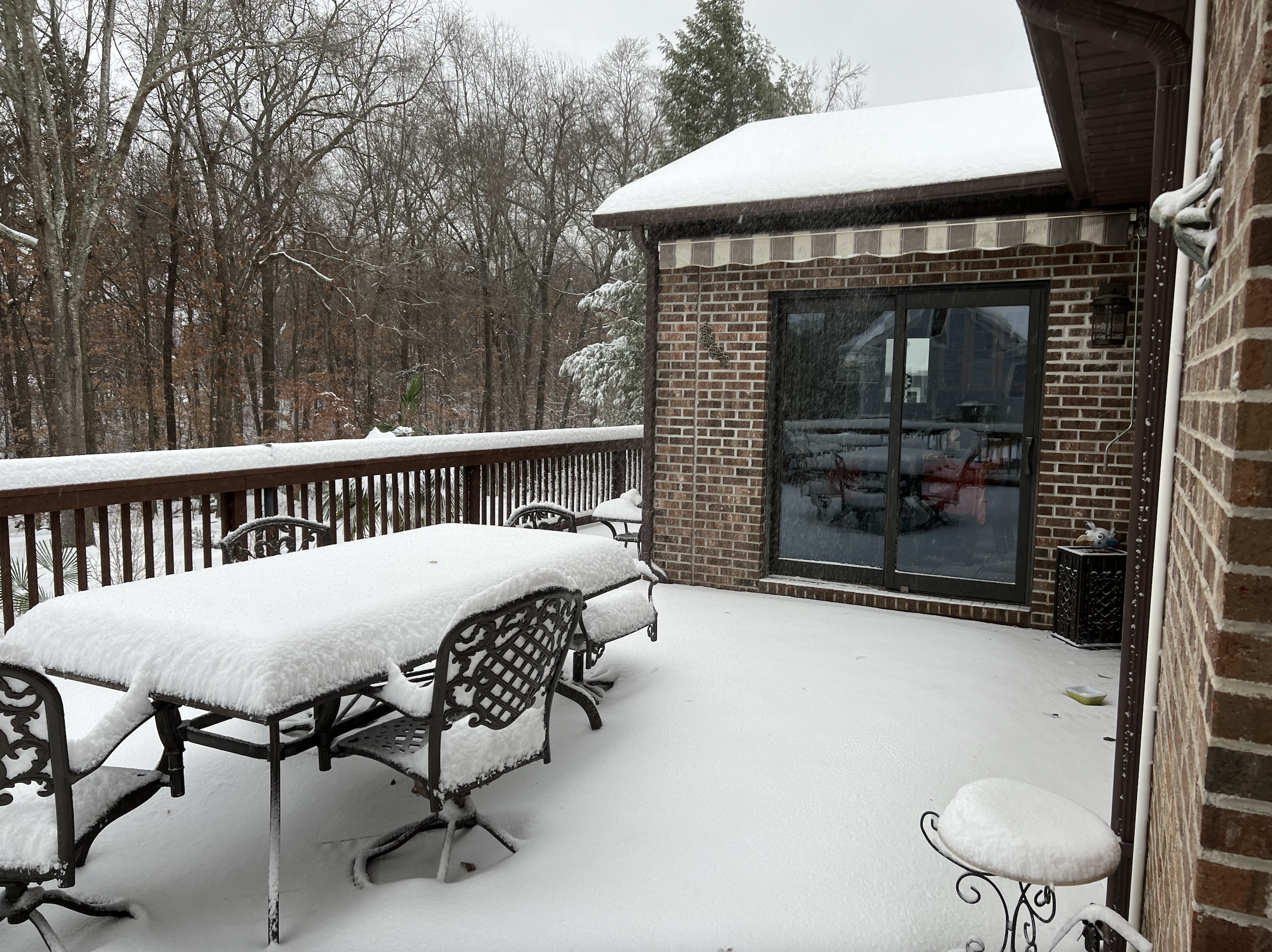
Ended up with 6.5" total as things were wrapping up around 730pm. Overall great event for the greenville area and really thankful all the precipitation stayed frozen (snow, sleet) with little to no freezing rain. Congrats to those who saw some impressive totals up in the NC mountains!