

iBrian
-
Posts
44 -
Joined
-
Last visited
Content Type
Profiles
Blogs
Forums
American Weather
Media Demo
Store
Gallery
Posts posted by iBrian
-
-
Buddy in Nashville under Winter Storm Watch for 3-7".
Third such totals for them in the past 2-3 weeks. Dahel??
 !
!
-
 1
1
-
 3
3
-
-
35 minutes ago, Indystorm said:
The snow looks so fresh and clean here in Griffith as it falls at a nice steady pace. But I will also be looking for svr wx concerns down south later this week.

-
1
-
-
1 hour ago, A-L-E-K said:
Points 4 daytime flakes, seems these types of events have been 6z affairs lately
yeah, this. since I moved here 2 years ago most snowfall events seem to have occured overnight. not much joy in that.
-
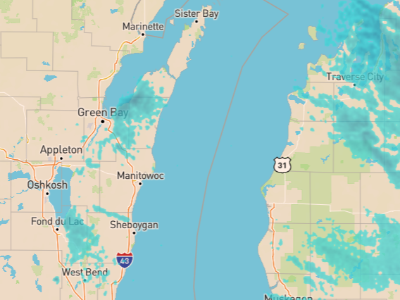
Does Lake Winnebago make it's own LES? Looks like Green Bay does as well. That's cool (I'm from the South and still learning such things).
-
1
-
 1
1
-
-
On 9/12/2021 at 12:05 PM, CheeselandSkies said:
Fine. Excessive speed far beyond the limits of what the road was designed for.
...and beyond the limits of the driver "training" we have in the U.S. compared to Europe.
-
2
-
-
3 hours ago, luckyweather said:
Losing 2 minutes of daylight daily here at 43 degrees north as we’ve left the solstice in our distant wake, full steam ahead to the equinox.
Hush yo mouth!
")
-
47 minutes ago, Malacka11 said:
Aurora received the greatest 24-hour rainfall (16.94 inches) in Illinois history, exceeding the previous record of 16.54 inches at East St. Louis on June 14, 1957. A broad band of 8-inch-plus rainfall from just south of Rockford to a little north of Kankakee exceeded the 7.58 inch threshold regarded as the average 100-year (once every 100 years) 24-hour storm for a given point in northeast Illinois. The deluge in Aurora was considered a 1-in-1,000-year event. The Joliet Brandon Dam measured 13.60 inches, and a gauge in the extreme southwest corner of the Chicago metro area recorded 10.99 inches. Strong thunderstorms hit on the afternoon of the 17th, but the greatest rainfall in most areas occurred in early morning thunderstorms on the 18th.
Wow. Never knew that was a thing. Shared assuming there's at least one other ignoramus like me in here
Man, I moved here almost 2 years ago and thus have never heard of it. I went through the great flood nobody knows about, but even that "only" put down this much rain. "In two days, a record of 13.67″ of rain fell in Nashville, nearly doubling the old two day total from the remnants of a hurricane in 1979."
-
Hmmm...
yet, moving southward is...
-
4 minutes ago, TimB84 said:
Sh*t, I’ve been found out.
 the answer must be, "Yes!"
-
Just now, iBrian said:
that article is from the future...

-
29 minutes ago, TimB84 said:
that article is from the future...
-
-
Some good lake effect returns coming off of Huron for you Ontario folks.
-
I shot this yesterday afternoon here in Lake County, IL
-
4
-
 1
1
-
-
radar starting to rotate and push slowly north...
-
8 minutes ago, Baum said:
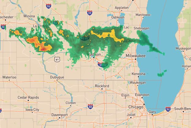
it seems the immediate Chicago metro is working itself back to the 3-4" totals that looked reasonable before yesterday's 12Z runs. Shame, would have been a nice storm if a phase had occurred.
looking at the radar the precip shield is looking to overtake all of Chicagoland this afternoon / evening. or, is it going to take a dramatic turn East?
-
9 minutes ago, UMB WX said:
^ BDoB
Sorry, newb question, but I just moved to the area from down south in November - does the radar filling in over northern Illinois the past hour have anything to do with the lake?
-
10 minutes ago, mimillman said:
ORD plumes back over 3”. That’s over 1” jump in the past two runs.
Alek

Google is a mess on this one - would somebody please explain to me the significance of "plumes?" Thanks!
Feb 1-3rd GHD III Part 2
in Lakes/Ohio Valley
Posted
you moved back here??