

Hailstorm
-
Posts
1,108 -
Joined
-
Last visited
Content Type
Profiles
Blogs
Forums
American Weather
Media Demo
Store
Gallery
Posts posted by Hailstorm
-
-
I recall many posters on another board expected us to have a "torch" March, April and May after last winter's debacle. That never materialized and we may even finish June below normal pending on the outcome for the second half of this month.
I would not bank on a warmer-than-normal summer for us. This current spring reminds me a lot about what transpired in 2009 - and we all know what happened with that summer.
Can anyone share the statistic for the latest date of a 90-degree day at Central Park in any given summer? It would be appreciated.
-
6 hours ago, IntenseBlizzard2014 said:
I'm so bored.
How so? It's Christmas. Nice time to be festive as we come closer the much-anticipated wintry period.
-
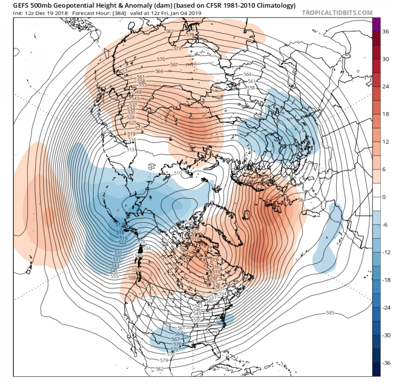
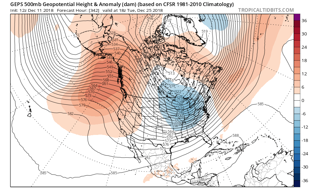
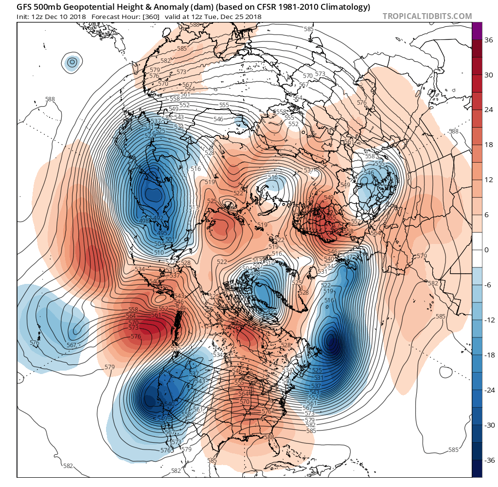
It's very promising that at the end of the 12z GEFS run, we are seeing it resemble Monday night's Euro weeklies to an extent. Notice how we are seeing higher heights in the Greenland area, which start to extend towards the AO and EPO region as we head into January:
-
 2
2
-
-
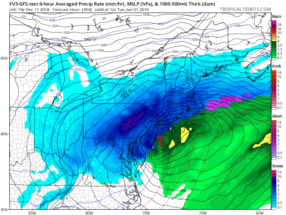
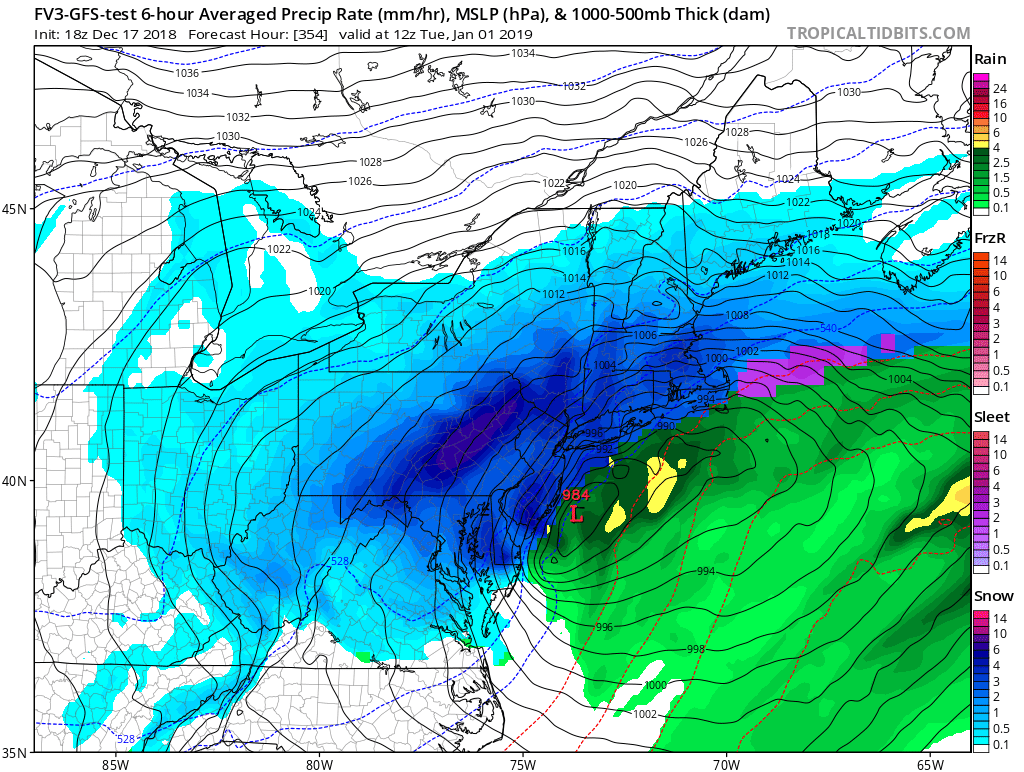
Just for giggles and entertainment (but unlikely to happen), take a look at this '93 redux fantasy Northeast bomb / blizzard on the recent FV3 model towards New Year's. I'd pay $500 for that to materialize just to see how all those tourists will react in the middle of a fierce snow blitz during the Times Square ball drop.
-
3
-
 2
2
-
-
2 minutes ago, Rjay said:
Flopping around like a fish
Agreed. They have been very erratic lately and I instead would defer to the Euro seasonal monthlies which tend to be less volatile.
-
8 hours ago, Snow88 said:
Storm signal continues near Xmas
I'm surprised the ensembles were not posted today. GEFS and GEPS look great, at least for cold, on/after 12/21. A little bit of a WAR setting up offshore which can amplify storms closer to the East Coast:

-
3
-
-
11 minutes ago, Snow88 said:
Models have some light snow possible for Thursday night
Too early?
It's December
Everything is pointing to a colder and possibly stormier last week of the month. Maybe a white Christmas?
I think chances are somewhat higher than normal for a white Christmas this year. Look at how the 18z GFS changed from its 12z run. It now shows extensive cross-polar flow for the northern half of the USA, with a humongous -EPO, -AO and east-based NAO. Ideally, we would want a bit of a less suppressed look than what is shown in the image below; however, it will inevitably change as we get closer in time.
New run:
Old run:
-
1
-
-
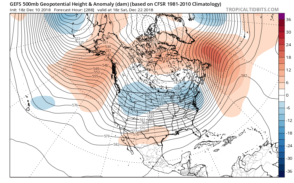
18z GEFS actually suggests a favorable pattern manifests itself for us at the end of next week (22nd), well before Christmas.

-
2
-
-
2 hours ago, donsutherland1 said:
One run, there was no snow at all. The next run there was 14". The former was a bleak nightmare. The latter was a wonderful dream.
The city in question was Richmond. The model in question was the GFS. The runs were the 12/3/2018 12z and 18z runs.
Run-to-run continuity was lacking.
At this stage, it continues to appear that a storm will likely bring accumulating snow to portions of the Carolinas and Virginia. Cities such as Richmond and Raleigh will likely see accumulations.
Whether the storm comes far enough north to bring at least light accumulations north of the Mason-Dixon line remains to be seen. However, even if it does not, winter 2018-19 still appears to be in line for above to much above normal snowfall across the Middle Atlantic, southern New England, and parts of the Great Lakes region. There still remains a window of opportunity for additional snow in the above region during the last week of December as the pattern becomes more volatile in the latter stages of a milder regime.
Winter 2002-03 continues to provide insight. Much as happened then, the EPO is forecast to go positive. The latest EPS weekly forecast takes the EPO back to negative levels (ensemble mean) by around December 21. Afterward, it stays negative through mid-January (the end of the forecast period). In addition, during much of the time, the same guidance favors a negative AO. The EPO-/AO- combination was an important assumption in my expectation that winter 2018-19 will be very snowy in the Northeast. That such a combination is showing up on the EPS weekly guidance is an encouraging development.
Very detailed and thought-provoking analysis! The latest Euro weeklies that were released tonight depicted a pervasive cross-polar flow from Siberia developing during mid-January. If that scenario verifies, would it be reasonable to ponder that January 2019 can finish with <5 temp departure for NYC, considering the record snow cover, low solar and all the other factors mentioned in your winter outlook? I would love that to play out because NYC desperately needs to set new record low maximums and minimums during winter, lol.
-
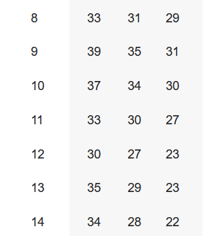
Weather Channel forecast for NYC between December 5th-12th is very reminiscent of December 2013. It has 8 straight days of high temps remaining in the 30s. We all know how the Winter of 2013-2014 played out, so let's hope it comes to fruition.
Dec 2013 High Mean Low
-
1
-
-
The question now becomes: Can Central Park tie or break its 14-degree record low set on the 23rd? It's now 18 degrees in the park.
-
1
-
-
2 hours ago, Snow88 said:
Wow weeklies are cold throughout December
If the Pacific and Atlantic blocking decide to take a break, I hope it occurs between 12/10-12/22. I do not want another Grinch storm / blowtorch for Christmas like it has been for 3 of the last 5 winters.
-
2
-
-
Hopefully, we can put those NYC record low maxes of 23 and 25 in play for the 22nd and 23rd, respectively. From what I recall, the 12z EURO/GFS hints that NYC may not rise above the mid 20s for highs during one of those days.
In other news, it looks like the NWS is sticking to its guns for a warmer-than-normal winter for a majority of the USA in its updated winter outlook, surprisingly:
QuoteNOAA’s Climate Prediction Center (CPC) updated their winter outlook covering December through February. Warmer than normal weather is still anticipated across much of the northern and western U.S., with the greatest likelihood in Alaska and the Pacific Northwest. Below average temperatures are not favored in any parts of the nation through the period.
Minimal changes were made to the precipitation forecast. Wetter than average conditions are still anticipated across the southern tier of the U.S. up into the Mid-Atlantic. Northern Florida and southern Georgia have the greatest odds for above-average precipitation this winter. Below normal precipitation are most likely in the Great Lakes and northern Ohio Valley. The previous forecast issued last month also included drier than normal weather in the northern Rockies, but this area has been removed.
http://www.weathernationtv.com/news/updated-winter-outlook-from-noaas-climate-prediction-center/
-
1
-
-
Don, that is a very insightful and constructive outlook as usual.
It looks like you are predicting that the core of the cold anomalies will be centered in the OH / TN valleys.
Is there any probability that the core of those negative departures can shift more towards the Northeast if the Aluetian low / -EPO ridge adjusts eastward?
I mention this because those are very significant cold anomalies shown on the maps.
-
2
-
-
I am optimistic that we will see a 1/3/2014-type powdery snowstorm with frigid temps (single digits) this winter season. Those are my favorite types of storms. NYC becomes eerily quiet and very few people roam the streets.
-
1
-
-
4 hours ago, tdp146 said:
Did you send the NWS your email address via this page in order to get access to run that model? https://slosh.nws.noaa.gov/sloshPub/disclaim.php
Yes, I submitted my personal e-mail address to them and got a username and password within 48 hours.
-
20 hours ago, LibertyBell said:
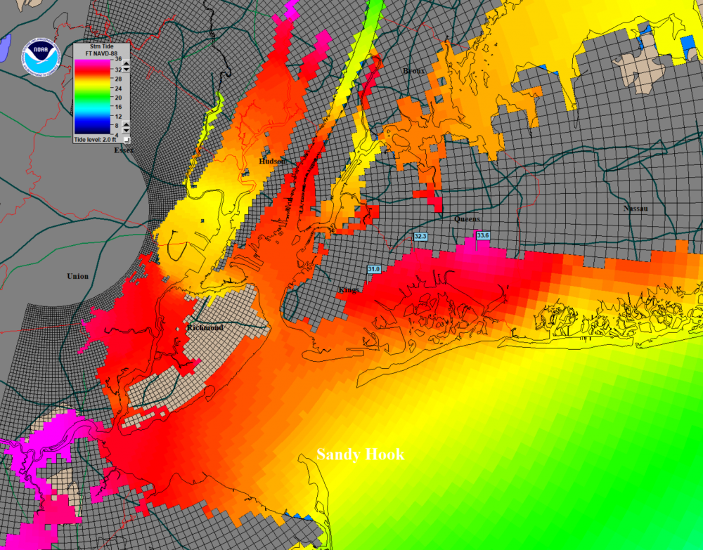
Wow almost 34 ft near Southern Queens, I wonder why it's less in Southern Nassau? Was this from a track modeled into Sandy Hook of a 145 mph hurricane? It would be interesting to see the same track modeled with different intensity hurricanes from 1-4. Also with the new climate regime of stalling hurricanes I wonder how much worse it would be to have a Cat 3/4 stall right along the coast, similar to what the Dec 1992 noreaster or the Ash Wednesday 1962 storm or what Harvey did or what Florence might do.
I would assume the proximity to another large body of water (Jamaica Bay) would account for the extra surge in Southern Queens. For reference, this was assuming the worst-case scenario track, direction and speed in which a hypothetical hurricane would take up here. The exact factors that make up this scenario were a mid-range Cat 4 hurricane (so I assume around 145 MPH) that was racing NW at 60 MPH (very possible, aka the 1938 one) at normal high tide before making landfall in Monmouth County. I assume a stalling hurricane would enhance the surge, as long as upwelling is not a large issue and the hurricane-force wind field has a huge diameter.
-
1
-
-
2 hours ago, LongBeachSurfFreak said:
Definitely not a worst case scenario. That would be a purely tropical cyclone with intact core moving rapidly NW out of the Gulf Stream with a landfall in Monmouth County. That would put NYC in the NE eyewall. I think the upper end of what’s possible is about 130mph. A 20’ surge into Ny harbor and major wind damage. Plus be the worlds first 1 trillion dollar disaster.
I definitely agree with this. According to the SLOSH models I have just run, parts of Brooklyn and Queens could get slammed with up to a 32-foot storm tide in a Cat. 4, assuming the impact coincides with high tide. Sandy, by comparison, "only" produced a storm tide of 11 feet in Manhattan. This would make Sandy appear to be "child's play" if that scenario came into fruition; as the surge would penetrate at least 3 miles further inland along the south-facing shorelines of Brooklyn, Queens and Long Island.
-
2
-
-
6 minutes ago, Mophstymeo said:
TWC is saying the same thing. Maybe they're right?
Are they saying this on-air? Their online site video and local text forecast says 4"-8" for NYC.
-
Lmao, Lonnie Quinn from CBS 2 going down the ship with the Canadian model and predicts 1"-3" for NYC.
-
1
-
-
I kind of find it funny how the Mid-Atlantic folks on this forum seem to like the upcoming cold pattern way more than the NYC forum.
It feels almost as if they expect another 2009-2010 snow apocalypse for them this month.
For December, just give me two 4-8" snowstorms that occurs with temps in the teens/lower 20s along with great snow pack retention (-5 or lower monthly temp departure) and I'm happy.
Hopefully, any relaxation in the pattern happens after the 25th.
The 12"+ storm can happen in January.
-
27 minutes ago, snywx said:
Do you ever stop? Ill give you credit tho atleast its in the banter thread
I believe he and snowman are in cahoots with each other.
Hopefully, PB GFI can sound him off with the real facts in here.


June 2019 General Discussions & Observations Thread
in New York City Metro
Posted
GEFS continues the theme of diminishing the longevity and strength of the Southwest Ridge between 06/26-06/29. It even hints at a backdoor trough trying to form over the Northeast as we approach July 4th. If this trend continues, I think it is more likely than not that Central Park ends up with a below-normal June. If this happens, then it would be the only below-normal May-June couplet in many years.