PaulyFromPlattsburgh
-
Posts
532 -
Joined
-
Last visited
Content Type
Profiles
Blogs
Forums
American Weather
Media Demo
Store
Gallery
Posts posted by PaulyFromPlattsburgh
-
-
Feels almost like a lake effect experience
-
I’m in some kind of upslope band been getting 1-2 inches an hour for the past 3 hours. Close to a foot here already total
-
 1
1
-
-
56 minutes ago, Ericjcrash said:
Plattsburgh ratios ridiculous on this clown.

I would love that haha!
-
1 minute ago, tim123 said:
15
Wow nice looks like I’m in a perfect spot. RGEM burries me
-
1 minute ago, Ericjcrash said:
I'll play.
BUF - 1.8”
ROC - 4.5”
SYR - 7.2”
ALB - 8.7”
BGM - 12.3”
Plattsburgh?
-
Wow my area looks to score somehow from the redeveloping coastal?!!
-
Sad storm for me. 0.2 inches lol mostly virga. Congrats to the rest. Waiting for the northern Adirondack special
-
 1
1
-
-
7 minutes ago, wolfie09 said:
What a beauty

1.5" LE all enhancement/lake effect and euro doesn't usually show lake effect well lol

congrats Wolfie. This is your event. Enjoy
") you deserve it
you deserve it
-
 1
1
-
-
2 minutes ago, BuffaloWeather said:
The NAM and Canadian are worst on verification scores. It goes Euro, UK, GFS. So the GFS is not a bad model. However its highly unlikely the latest run comes to fruition.
Show me these verification scores? The GFS has been playing catch up all year. We were talking about this since November that's why I am so confused. NAM has been very accurate in its short to mid range last time I checked Verfication scores. would love to see them for myself and clear up the confusion. I apologize in advance and thank you
-
 1
1
-
-
CMC is 991 same time GFS is 976. Clearly GFS is way to amped in this set up. also GFS never develops the secondary which almost every model is showing.
-
2 minutes ago, rochesterdave said:
Synoptically, it’s a decent set up for IAG at least. Euro and Ukie have shown it for a couple runs now. LE set up is very bad for Roc and BUF (city north)
please look at the CMC because it validates my concerns... warm and rainy for roc. lets not all hug the GFS all at once lol
-
GFS is such a bad model. IDK where where its getting these crazy totals. I would cut that by half to one third at least... That would be low ratio isothermal wet snow of Rochester at best that run.... I would go with a blend of the NAM and Canadian on this one... and not get any synoptic hopes up... LE is where you will score. I hope you all get feet on snow just cannot be oblivious to this track and set up. Synoptically not favorable for many in WNY and even my area...
-
NAM fishes it out again
-
I did not like that Euro run! We need something more like what the CMC(GDPS) or the NAM is showing. The NAM has this sneaky tendency to fish things out and end up being correct in its rather ominous LR! I have a funny feeling we end up with a NAM/NAVY type solution more southern and eastern developing SLPS
-
11 minutes ago, wolfie09 said:
Ukmet with some decent synoptic snow over WNY , heck of a nice lake effect band as well, especially considering it's at 10-1...By tomorrow evening we should start getting into SR guidance time..

There will be a CCB band forming and where that forms will dictate where the heaviest axis of snow occurs. I am very interested in this . Most models are cold for upstate now! I am talking about the synoptic system! That is where my interest are. Obviously my area gets zero lake effect
-
1
-
-
This storm is trending in the right direction! My interest has risen significantly now that that Surface LP forms south and east of my area! Looks like a potential page job incoming for the northern Dacks with significant frontegensis!
-
7 minutes ago, rochesterdave said:
Definitely goes negative

NAM is best case scenario with that H5. Nice back door CF.
-
1 minute ago, rochesterdave said:
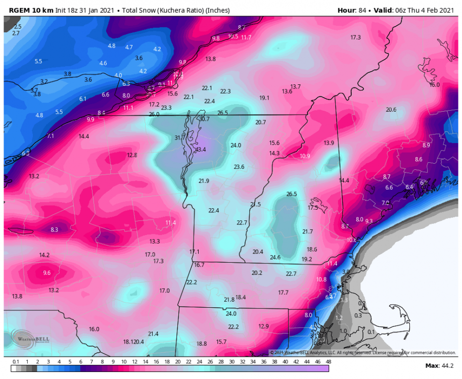
RGEM likewise showing a long duration, hvy snow band into Syracuse. Gonna be a big one for someone.

Noise.
-
1
-
-
Finally some moderate snow after hours of virga. Very windy and cold out. Expecting an inch or less. Pretty inactive pattern ahead it looks like. Going back into hiding. Have a good day
-
Just chiming in real quick. This was the reason why I wasn’t excited for this one from the get go. It looked very disorganized, very weak(strung out), and lacked any type of moisture. I was forecasted 3-5 inches and seen less than a trace of snow. BUST. Glad I didn’t get excited for this one
-
1
-
-
Just now, wolfie09 said:
.thumb.png.21d291a1d50d1132bac34e9b1863a824.png)
Nice looks like a widespread 1-3 2-4 inch deal adding to the pack
-
That day 4-5 threat is very interesting for the NYC area with potential for at least a few inches of accumulating snow. ICON and GFS hinting at this well
-
1 hour ago, BuffaloWeather said:
Finally looks like winter
Jesus Maine is buried. Caribou area NNW Maine!
-
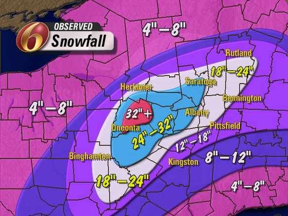
Finished with a total of 17 inches from round 2! Plus 1.5 inches of snow with .2 inches of ice from first round. A little more than my original new snow forecast of 15.5 inches.
-
2
-


.png.bcccb3b0ee861853f4c8f60259901de7.png)
Synoptic Snowstorm 2/1-2/4
in Upstate New York/Pennsylvania
Posted
Absolutely ripping whiteout. 30 DBZ band. Anyone know what’s causing this surprise band. Usually the Froude values are so high we never cash in on upslope.