
Delaware Valley Weather
-
Posts
156 -
Joined
-
Last visited
Content Type
Profiles
Blogs
Forums
American Weather
Media Demo
Store
Gallery
Posts posted by Delaware Valley Weather
-
-
Looks like 2-3" on the cmc before a changeover on Wednesday. Not much on the gfs just some light snow as the precip moves in.
-
7 minutes ago, KamuSnow said:
Yeah, I'll take one of those please.
Yup. Give me one of those in the first week of March and then a quick flip to spring in the second.
-
10 hours ago, specialsk said:
Sorry, but this "sub-forum" is a joke. Worst participation on the whole site, especially as a major metro. Winter not going your way, then bail? Hmmm...the sports analogies to the hometown are stunning.
And before you start asking "Who are you?", rest assured I tried to start conversation here once or twice, but when you're not in "the clique," guess you don't count. Vicious circle.
Anyway, here's to Spring 2019.
^ The late winter meltdown never gets old. Someone get this guy a blizzard.
-
3 minutes ago, The Iceman said:
Not falling for it again, not falling for it again, not falling for it again....
I Hear ya. I'm going to be cautiously optimistic until a similar look continuously shows up within 7-10 days. With the mjo in favorable phases for a little while I would think its just a matter of time though that we get a decent looking h5. Even if it is only for a brief time. And hopefully we can just time something right when it does show up.
-
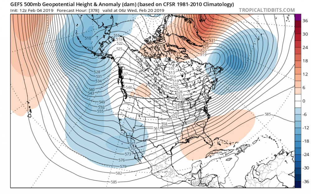
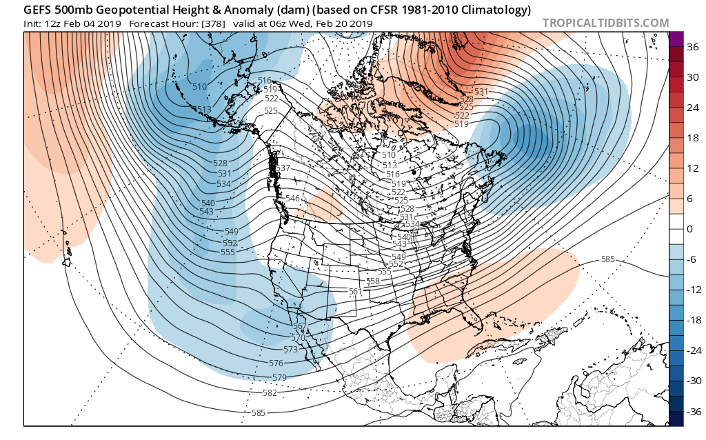
The long range looked pretty good on 0z gefs. Trough swings east end of month with lots of high latitude blocking. Hopefully we can get that look to continue to move up in time.
-
32.5 in Exton. Sleet coming down at a decent clip.
-
1.5” for part II. 3” total. Zr and ip mix in Exton now. 30.2
-
7 hours ago, ChescoPaWxman said:
Exton averages about 32" a season so maybe a big MECS will be needed!
Make it a hecs then.
-
3 hours ago, ChasingFlakes said:
Did you accumulate anything during the afternoon? Phoenixville didnt see snow until 7:45.
Also it's always cool to drive from the bottom of the hill I live on which is 150' in elevation at the bottom, to 600' at the top. Just that 400-500 ft elevation change is noticeable as the driveways and road always accumulate up top first. The lawns also always hold more snow despite the same northeast aspect. That 1-1 1/2 degree F average temperature difference during precipitation can be noticeable in marginal mixed events like this.
Nothing accumulated after about 830 am or so. Even though it snowed lightly after that time it warmed above freezing and the sun could be seen through the clouds.
On the elevation topic...I remember a storm here in 2001 where we had about a foot in lionville and only 3” in downingtown. It was a very elevation dependent storm. At one point early in the morning there was a driving snow, several inches and snow covered roads on the top of the hill while a half mile away down the hill it was raining. The hills were literally snow capped. Pretty crazy event and one of my favorites.
-
 1
1
-
-
.8” in Exton for part 2.
2.3” combined.
14.7” for the season.
And 1 mecs away from an average season.
-
Very light snow here in Exton. 33
-
1.5” in Exton. Temp up to 31.
-
1 hour ago, ChescoPaWxman said:
Latest Wxsim with 6z data - not too much wintry once past Tuesday AM... rush not bad at all
Paul, does wxsim use 3km nam data or just 12km nam?
-
6 minutes ago, Ralph Wiggum said:
HDRRP better. GfS coming in colder and wetter.
GFS is 10 degrees colder than 6z along 95 Tuesday evening.
-
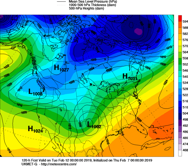
Big changes out west on the gfs. Went to a more ukie type look.

-
Looks like 8 by mid-month
-
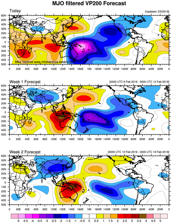
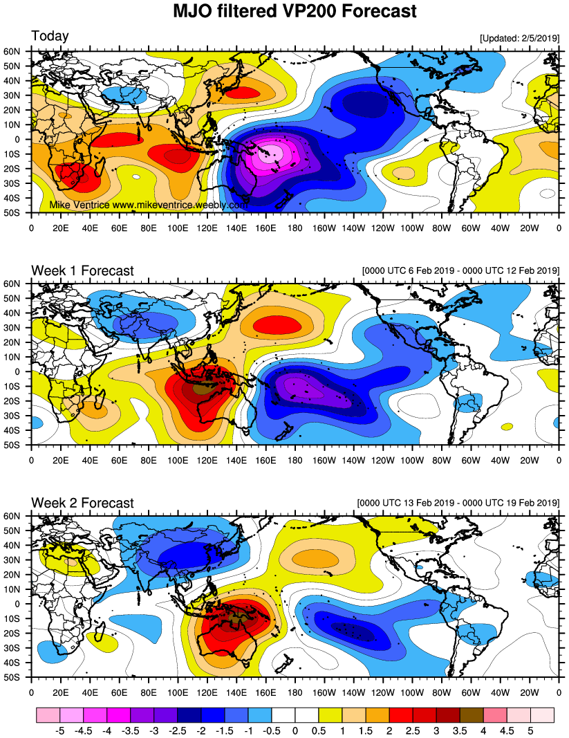
VP maps look good for week 2. Mjo likely to go into phase 8 and probably 1 imo.
-
Ukie looks closer to Euro at 144.
64 in Exton right now.
-
1
-
-
43 minutes ago, Ralph Wiggum said:
JP with that setup the weak SE Ridge is absolutely crucial otherwise the ripping NS will suppress the best boundary too far South. I think we r in a good spot moving forward in terms of pattern and potential. Nor sure I buy the NAO ridge verbatim as weve been teased many times already BUT we dont need a sustained neg NAO to produce solid overrunning events. Now if we time a wave with even a transient neg NAO then we could be looking at quite an event. I'm more interested in the gradient look tho for now and staying away from the unicorn hunt. A couple low warning level events heck even ONE would suffice for me. Get something better and that's just gravy.
Yea Its tough to bite on the neg nao. It could happen but there’s been too many head fakes to get excited about it popping in the long range. I too am more interested in the gradient pattern possibly producing something moderate in the 7-10 day. However, if we were to progress into the type of pattern the gefs shows in the long range, that could produce something big. -nao and 50/50 with a split flow. This look will probably be different at 0z lol but with the mjo moving into favorable phases who knows.
-
Great looking pattern on the gefs in the long range. Active southern jet and northern jet supplying the cold air. Higher heights over Greenland.
-
 1
1
-
-
54 on the home station. Up from a low of 24. Crazy spread across the region with Dover still at 38.
-
4 minutes ago, wkd said:
Nice to have another seemingly knowledgeable poster in this subforum. Maybe it will help build up the following.
Hopefully I can bring some good content. I look forward to engaging in some good discussion here.
-
16 minutes ago, Newman said:
If the Euro is correct (which it likely will be looking at VP 200 maps), the MJO will make it's way through p8 and p1 which will open the door for the cold to press back into the east after a 5 day stretch of warm. The GFS suite is showing the blowtorch SE ridge likely as a counterpart to it's MJO forecast. We'll see who is right this time around.
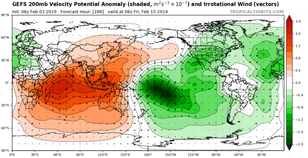
I agree. Looking at gefs vp maps I would think it would bring the trough east like the eps did after the 11th. I also don’t know if the gefs is maybe picking up on nino forcing here.

-
Looking at the vp maps on the gefs one would think that should argue for a trough farther east in North America. Not sure if the gefs is picking up on Niño forcing here or just bringing the mjo into p8. Either way, having convection centered east of the date line should bring good things.
-
3
-
1
-


E PA/NJ/DE Winter 2018-19 OBS Thread
in Philadelphia Region
Posted
The ICON is an idiot, but it looks similar to last nights Euro. Not as much of an initial thump as Euro but 2-4 over to ice north and west of the fall line.