

Buckeye1994
-
Posts
25 -
Joined
-
Last visited
Content Type
Profiles
Blogs
Forums
American Weather
Media Demo
Store
Gallery
Posts posted by Buckeye1994
-
-
5 minutes ago, Gino27 said:
I think we could get a lot more than 2-3 inches even with the current track. Ratios will be extremely efficient and an occluded low in that position can pull from Lake Michigan.
Strong winds could cut down on ratios due to just sheering the snowflakes to pixie dust as they fall
-
 1
1
-
-
Dayton and Columbus Ohio are again begging for a shift eastward… if not another cold rain followed by a back side tease of wind driven 2-3 inches
-
2
-
-
Dayton Ohio most likely a cold rain and 2-3 wrap around inches.. always on the wrong side of the rain/snow line
-
I’ve been following this forum for a few years, haven’t really said anything just really enjoyed the information. Thought I would finally join in
I live in Germantown, OH (SW of Dayton)
this storm brought us 6” of snow on top of about an inch of sleet. Still snowing also
-
1
-
 1
1
-
-
Looks like a nice spring tease early next week with a return to mid 40s for a while after. Ready for this raw weather to finally give up and move on out
-
21 hours ago, Jackstraw said:
The FV3 says nope! lol

Actually the 12z FV3 agrees with both GFS and NAM
-
8 hours ago, chuckster2012 said:
Next system on Thursday p.m. looks like Ohio could get a pretty good front end snow dump before change to rain for so. 2/3 of state..
If only the Euro and Candadian models were on board even a little bit

-
5 minutes ago, Angrysummons said:
Push to around 25 inches? Not a chance. My parents have counted 19 inches now in their backyard and rejected that TT stuff as "snow".
Didn’t realize we all lived in your parents backyard lmao. My man you just need to leave this forum
-
Storm late this weekend is starting to look mighty interesting
-
Heavy rain in Germantown along with 3-4 inches of packed down wet snow is causing a lot of street flooding
-
Very heavy snow for over an hour now here just south of Dayton, picked up well over an inch. Still all snow, can’t hear any ice pellets mix in yet
-
I think a solid 3-6 inches in Montgomery County. there will be ample moisture with this system. Snowfall rates will be tremendous, could boom imo. But if the warm air surges faster than previously thought, 1 inch of slush and a miserable rain could also be on the table.
-
Looks like things are going to start to heat up (snow) next week.
-
1
-
-
4-4.5 here in Germantown, roads were a mess on my way to work
-
Pretty good banding setting up in central Indiana. Hopefully it holds up
-
Snow starting in Germantown (just south of Dayton) right now. Temps hovering around 10..... looking for 3-5
-
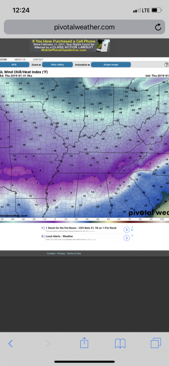
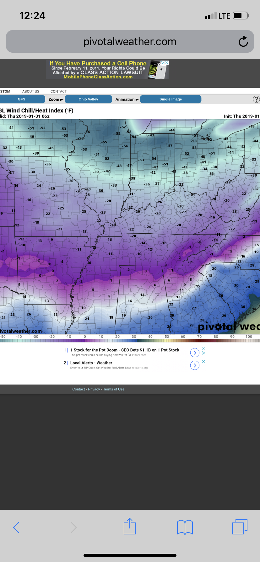
Wind Chill in Dayton dropped below -36 ... making it the coldest it’s been since January 1994
-
Very heavy snow squall just moved through southwestern Montgomery County ahead of the arctic front, dropped a quick 0.5, wind blowing it all around.
-
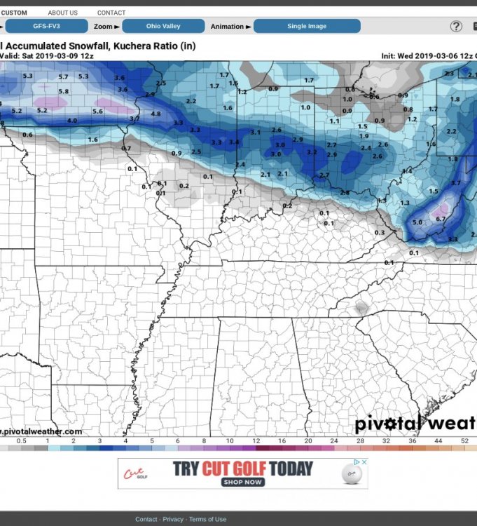
updated GFS map on the potential quick hitter later this week

-
1
-
-
4 hours ago, chuckster2012 said:
Get ready for Spring next weekend according to GFS..
06z took a 180 from the 00z
-
Something else we have to worry about for middle of next week
-
18z GFS. 168 hours. Shifted the Monday clipper
-
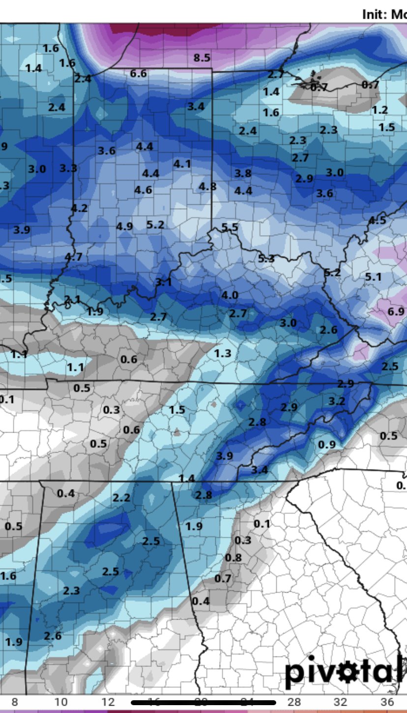
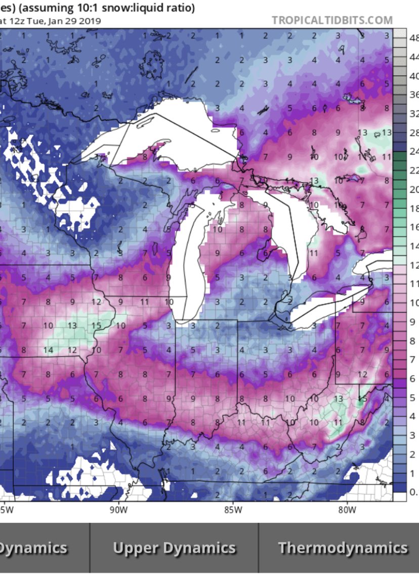
As of right now, looks as if some back end snow for the storm system this week might drop (Trace-1/2inch) of snow on the central Miami Valley with a 2-4 inch Clipper System to watch this weekend.
-
Driving to work this morning looks like Germantown got anywhere from 4-6 inches
feel as rain mostly of the day, turned to freezing rain around 6:30-7 , then straight snow around 8:30

Pre-Christmas (Dec 21-23rd) Winter Storm
in Lakes/Ohio Valley
Posted
Dayton Ohio left out to dry yet again